
Wearhead topographic map
Click on the map to display elevation.
About this map
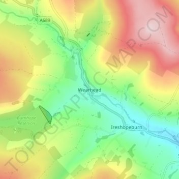
Name: Wearhead topographic map, elevation, terrain.
Average elevation: 1,424 ft
Minimum elevation: 997 ft
Maximum elevation: 1,975 ft
Other topographic maps
Click on a map to view its topography, its elevation and its terrain.
South Agnew Plantation
United Kingdom > England > County Durham > Newton Aycliffe
Average elevation: 328 ft
Derwent Gorge and Muggleswick Woods National Nature Reserve
United Kingdom > England > County Durham > Castleside > Healeyfield
Average elevation: 702 ft
North Pennines National Landscape
United Kingdom > England > County Durham
Average elevation: 1,066 ft
Great High Wood
United Kingdom > England > County Durham > Durham > High Shincliffe
Average elevation: 207 ft
Flass Vale Local Nature Reserve
United Kingdom > England > County Durham > Durham
Average elevation: 266 ft
Bishop Middleham Quarry Nature Reserve
United Kingdom > England > County Durham > Bishop Middleham
Average elevation: 377 ft
Oakey's Park
United Kingdom > England > County Durham > Stanley > West Shield Row Villas
Average elevation: 597 ft
Tunstall Reservoir
United Kingdom > England > County Durham > Wolsingham
The reservoir was created for the Weardale and Shildon District Waterworks Company, with construction of the dam between 1873 and 1879.[2][3] The earth embankment dam was built across the valley of Waskerley Beck, and measures 1,020 feet (310 m) long and 82 feet (25 m) high. It was constructed with a puddle…
Average elevation: 945 ft