
Make a donation
Gear up for your next adventure:
As an Amazon Associate, this site earns from qualifying purchases at no extra cost to you.
Luckenwalde topographic map
Click on the map to display elevation.
Make a donation
Gear up for your next adventure:
As an Amazon Associate, this site earns from qualifying purchases at no extra cost to you.
Luckenwalde
Luckenwalde liegt etwa 50 Kilometer südlich von Berlin, was durch den Merkspruch Luckenwalde, Luckenkien, 50 Kilometer vor Berlin. ausgedrückt wird. Nördlich von Luckenwalde liegt Trebbin, südlich Jüterbog, östlich Baruth/Mark und westlich Treuenbrietzen. In der Nähe des Marktturms beträgt die Höhe über dem Meeresspiegel 49 Meter, bei den Weinbergen westlich des Stadtzentrums sind es 77 Meter.
Make a donation
Gear up for your next adventure:
As an Amazon Associate, this site earns from qualifying purchases at no extra cost to you.
About this map
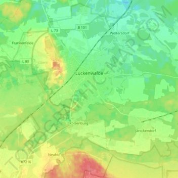
Name: Luckenwalde topographic map, elevation, terrain.
Location: Luckenwalde, Teltow-Fläming, Brandenburg, Deutschland (52.02684 13.08016 52.13402 13.21341)
Average elevation: 180 ft
Minimum elevation: 112 ft
Maximum elevation: 299 ft
Make a donation
Gear up for your next adventure:
As an Amazon Associate, this site earns from qualifying purchases at no extra cost to you.
Other topographic maps
Click on a map to view its topography, its elevation and its terrain.
Make a donation
Gear up for your next adventure:
As an Amazon Associate, this site earns from qualifying purchases at no extra cost to you.
Schloss Zossen
Deutschland > Brandenburg > Teltow-Fläming > Zossen > Finkenherd
Die Schlossanlage entstand im 13. Jahrhundert auf einer kleinen Anhöhe als Wasserburg vermutlich auf einem ehemaligen slawischen Burgwall als markgräflich-meißnerische Grenzfeste. Zossen gehörte vor 1349 der Familie zu Torgau (Towgow), deren Besitz von Karl IV. bestätigt worden war. Die Burg stellte dabei…
Average elevation: 125 ft
Make a donation
Gear up for your next adventure:
As an Amazon Associate, this site earns from qualifying purchases at no extra cost to you.
Mönningfeld
Deutschland > Brandenburg > Teltow-Fläming > Am Mellensee > Fernneuendorf
Average elevation: 161 ft
Naturpark Nuthe-Nieplitz
Deutschland > Brandenburg > Teltow-Fläming
Ein erheblicher Teil der Parkfläche entfällt auf die Großgemeinde Nuthe-Urstromtal. Vierzehn der dreiundzwanzig Dörfer und rund zwei Fünftel der mit 335 km² sehr ausgedehnten Fläche dieser Gemeinde liegen im Naturpark. Mit 13.265 ha nehmen Naturschutzgebiete 21 % und mit 41.700 ha ein…
Average elevation: 187 ft
Schmachtenhagen
Deutschland > Brandenburg > Teltow-Fläming > Zossen > Dabendorf
Average elevation: 138 ft
Make a donation
Gear up for your next adventure:
As an Amazon Associate, this site earns from qualifying purchases at no extra cost to you.