
Make a donation
Gear up for your next adventure:
As an Amazon Associate, this site earns from qualifying purchases at no extra cost to you.
Axe Lake topographic map
Click on the map to display elevation.
Make a donation
Gear up for your next adventure:
As an Amazon Associate, this site earns from qualifying purchases at no extra cost to you.
About this map
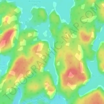
Name: Axe Lake topographic map, elevation, terrain.
Average elevation: 1,211 ft
Minimum elevation: 1,119 ft
Maximum elevation: 1,329 ft
Make a donation
Gear up for your next adventure:
As an Amazon Associate, this site earns from qualifying purchases at no extra cost to you.
Other topographic maps
Click on a map to view its topography, its elevation and its terrain.
Wolf Island
Canada > Ontario > Kenora District > Unorganized Kenora District
Average elevation: 1,073 ft
Burditt Lake
Canada > Ontario > Kenora District > Unorganized Kenora District
Average elevation: 1,204 ft
Make a donation
Gear up for your next adventure:
As an Amazon Associate, this site earns from qualifying purchases at no extra cost to you.
Cardinal (Lac) Lake
Canada > Ontario > Kenora District > Unorganized Kenora District
Average elevation: 1,286 ft
Hudson Bay Lowlands
Canada > Ontario > Kenora District > Unorganized Kenora District
Average elevation: 56 ft
Carroll Lake
Canada > Ontario > Kenora District > Unorganized Kenora District
Average elevation: 1,109 ft
Make a donation
Gear up for your next adventure:
As an Amazon Associate, this site earns from qualifying purchases at no extra cost to you.
Canyon Lake
Canada > Ontario > Kenora District > Unorganized Kenora District
Average elevation: 1,329 ft
Granite Lake
Canada > Ontario > Kenora District > Unorganized Kenora District
Average elevation: 1,165 ft
Make a donation
Gear up for your next adventure:
As an Amazon Associate, this site earns from qualifying purchases at no extra cost to you.
Gordon Island
Canada > Ontario > Kenora District > Unorganized Kenora District
Average elevation: 1,145 ft
Twin Lake
Canada > Ontario > Kenora District > Unorganized Kenora District
Average elevation: 1,309 ft
Make a donation
Gear up for your next adventure:
As an Amazon Associate, this site earns from qualifying purchases at no extra cost to you.
Clear Lake
Canada > Ontario > Kenora District > Unorganized Kenora District
Average elevation: 1,204 ft
Shoal Lake
Canada > Ontario > Kenora District > Unorganized Kenora District
Average elevation: 1,066 ft
Grindstone Lake
Canada > Ontario > Kenora District > Unorganized Kenora District
Average elevation: 1,217 ft
Look Lake
Canada > Ontario > Kenora District > Unorganized Kenora District
Average elevation: 1,289 ft
Make a donation
Gear up for your next adventure:
As an Amazon Associate, this site earns from qualifying purchases at no extra cost to you.
Warwick Lake
Canada > Ontario > Kenora District > Unorganized Kenora District
Average elevation: 1,119 ft
Slate Islands
Canada > Ontario > Kenora District > Unorganized Kenora District
Average elevation: 1,056 ft
Make a donation
Gear up for your next adventure:
As an Amazon Associate, this site earns from qualifying purchases at no extra cost to you.
Mackey Island
Canada > Ontario > Kenora District > Unorganized Kenora District
Average elevation: 1,102 ft
Big Island Lake
Canada > Ontario > Kenora District > Unorganized Kenora District
Average elevation: 1,411 ft
Make a donation
Gear up for your next adventure:
As an Amazon Associate, this site earns from qualifying purchases at no extra cost to you.
Nine Mile Lake
Canada > Ontario > Kenora District > Unorganized Kenora District
Average elevation: 1,355 ft
Arpin Lake
Canada > Ontario > Kenora District > Unorganized Kenora District
Average elevation: 1,257 ft
Mills Lake
Canada > Ontario > Kenora District > Unorganized Kenora District
Average elevation: 1,247 ft
Betula Lake
Canada > Ontario > Kenora District > Unorganized Kenora District
Average elevation: 1,217 ft
Make a donation
Gear up for your next adventure:
As an Amazon Associate, this site earns from qualifying purchases at no extra cost to you.
Beauty Lake
Canada > Ontario > Kenora District > Unorganized Kenora District
Average elevation: 1,142 ft
Chisholm Island
Canada > Ontario > Kenora District > Unorganized Kenora District
Average elevation: 1,060 ft
Clearwater Bay
Canada > Ontario > Kenora District > Unorganized Kenora District
Average elevation: 1,096 ft
Boyne Lake
Canada > Ontario > Kenora District > Unorganized Kenora District
Average elevation: 1,184 ft
Make a donation
Gear up for your next adventure:
As an Amazon Associate, this site earns from qualifying purchases at no extra cost to you.
Muskeg River
Canada > Ontario > Kenora District > Unorganized Kenora District
Average elevation: 1,171 ft
Slate Falls
Canada > Ontario > Kenora District > Unorganized Kenora District
Average elevation: 1,263 ft
Muskeg River
Canada > Ontario > Kenora District > Unorganized Kenora District
Average elevation: 1,191 ft
Dingwall Island
Canada > Ontario > Kenora District > Unorganized Kenora District
Average elevation: 1,066 ft
Make a donation
Gear up for your next adventure:
As an Amazon Associate, this site earns from qualifying purchases at no extra cost to you.
Little Boulder Lake
Canada > Ontario > Kenora District > Unorganized Kenora District
Average elevation: 1,178 ft
Cameron Island
Canada > Ontario > Kenora District > Unorganized Kenora District
Average elevation: 1,109 ft
Make a donation
Gear up for your next adventure:
As an Amazon Associate, this site earns from qualifying purchases at no extra cost to you.