
社硎乡 topographic map
Interactive map
Click on the map to display elevation.
About this map
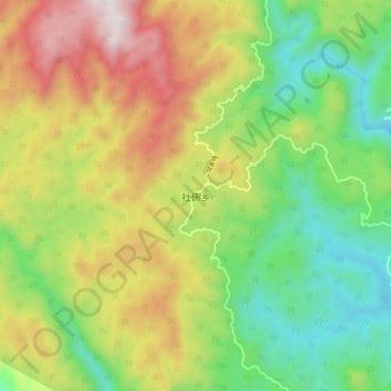
Name: 社硎乡 topographic map, elevation, terrain.
Location: 社硎乡, 仙游县, 莆田市, 福建省, 中国 (25.45223 118.59330 25.53223 118.67330)
Average elevation: 1,985 ft
Minimum elevation: 571 ft
Maximum elevation: 4,029 ft
Other topographic maps
Click on a map to view its topography, its elevation and its terrain.