
Make a donation
Gear up for your next adventure:
As an Amazon Associate, this site earns from qualifying purchases at no extra cost to you.
Mashpee topographic map
Click on the map to display elevation.
Make a donation
Gear up for your next adventure:
As an Amazon Associate, this site earns from qualifying purchases at no extra cost to you.
Mashpee
Like all towns on the Cape, Mashpee's topography is that of sandy soil, small ponds and inlets, surrounded by the pines and oaks indigenous to the area. The town's shoreline is framed by Waquoit Bay to the west and Popponesset Bay to the east, with several rivers, brooks and small ponds in the area. The town contains South Cape Beach State Park along Dead Neck and Waquoit Bay, and the Lowell Holly Reservation, comprising the land between Wakeby and Mashpee Ponds.
Make a donation
Gear up for your next adventure:
As an Amazon Associate, this site earns from qualifying purchases at no extra cost to you.
About this map
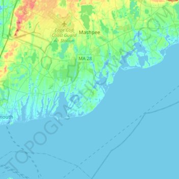
Name: Mashpee topographic map, elevation, terrain.
Average elevation: 33 ft
Minimum elevation: -36 ft
Maximum elevation: 236 ft
Barnstable County trails, hiking, mountain biking, running and outdoor activities
Make a donation
Gear up for your next adventure:
As an Amazon Associate, this site earns from qualifying purchases at no extra cost to you.
Other topographic maps
Click on a map to view its topography, its elevation and its terrain.
Marstons Mills
United States > Massachusetts > Barnstable County > Marstons Mills
Average elevation: 56 ft
Make a donation
Gear up for your next adventure:
As an Amazon Associate, this site earns from qualifying purchases at no extra cost to you.
Falmouth Heights
United States > Massachusetts > Barnstable County > Falmouth
Average elevation: 13 ft
Make a donation
Gear up for your next adventure:
As an Amazon Associate, this site earns from qualifying purchases at no extra cost to you.
Cliffside Estates
United States > Massachusetts > Barnstable County > Bourne > Sagamore Highlands
Average elevation: 59 ft
Make a donation
Gear up for your next adventure:
As an Amazon Associate, this site earns from qualifying purchases at no extra cost to you.
West Hyannisport
United States > Massachusetts > Barnstable County > Barnstable > Hyannis
Average elevation: 16 ft
Make a donation
Gear up for your next adventure:
As an Amazon Associate, this site earns from qualifying purchases at no extra cost to you.
Town of Barnstable Public Lands
United States > Massachusetts > Barnstable County > Barnstable > West Barnstable
Average elevation: 3 ft
Peters Pond
United States > Massachusetts > Barnstable County > Sandwich > Forestdale
Average elevation: 131 ft
Make a donation
Gear up for your next adventure:
As an Amazon Associate, this site earns from qualifying purchases at no extra cost to you.
Sandwich Fish Hatchery
United States > Massachusetts > Barnstable County > Sandwich
Average elevation: 75 ft
Make a donation
Gear up for your next adventure:
As an Amazon Associate, this site earns from qualifying purchases at no extra cost to you.
Make a donation
Gear up for your next adventure:
As an Amazon Associate, this site earns from qualifying purchases at no extra cost to you.
Santuit Pond
United States > Massachusetts > Barnstable County > Mashpee > Mashpee Neck > Pine Tree Corner
Average elevation: 49 ft
West Barnstable
United States > Massachusetts > Barnstable County > West Barnstable
Average elevation: 49 ft
Make a donation
Gear up for your next adventure:
As an Amazon Associate, this site earns from qualifying purchases at no extra cost to you.
South Orleans
United States > Massachusetts > Barnstable County > Orleans > South Orleans
Average elevation: 56 ft
Saconesset Hills
United States > Massachusetts > Barnstable County > Falmouth > Saconesset Hills
Average elevation: 33 ft
Red Brook Pond Dam
United States > Massachusetts > Barnstable County > Bourne
Average elevation: 39 ft
Make a donation
Gear up for your next adventure:
As an Amazon Associate, this site earns from qualifying purchases at no extra cost to you.
Mashpee Neck
United States > Massachusetts > Barnstable County > Mashpee > Mashpee Neck
Average elevation: 33 ft
Make a donation
Gear up for your next adventure:
As an Amazon Associate, this site earns from qualifying purchases at no extra cost to you.
South Chatham
United States > Massachusetts > Barnstable County > Chatham > South Chatham
Average elevation: 30 ft
Bog Pond Cr, Waquoit
United States > Massachusetts > Barnstable County > Falmouth
Average elevation: 23 ft