
Make a donation
Gear up for your next adventure:
As an Amazon Associate, this site earns from qualifying purchases at no extra cost to you.
Antietam topographic map
Click on the map to display elevation.
Make a donation
Gear up for your next adventure:
As an Amazon Associate, this site earns from qualifying purchases at no extra cost to you.
About this map
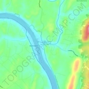
Name: Antietam topographic map, elevation, terrain.
Location: Antietam, Washington County, Maryland, 21782, United States (39.39621 -77.76222 39.43621 -77.72222)
Average elevation: 404 ft
Minimum elevation: 279 ft
Maximum elevation: 712 ft
Washington County trails, hiking, mountain biking, running and outdoor activities
Make a donation
Gear up for your next adventure:
As an Amazon Associate, this site earns from qualifying purchases at no extra cost to you.
Other topographic maps
Click on a map to view its topography, its elevation and its terrain.
Make a donation
Gear up for your next adventure:
As an Amazon Associate, this site earns from qualifying purchases at no extra cost to you.
Paramount-Long Meadow
United States > Maryland > Washington County > Paramount
Average elevation: 581 ft
Make a donation
Gear up for your next adventure:
As an Amazon Associate, this site earns from qualifying purchases at no extra cost to you.
Greenbrier State Park
United States > Maryland > Washington County > San Mar
Average elevation: 1,001 ft