Geolocate

James Peak topographic map

Interactive map

Click on the map to display elevation.

About this map

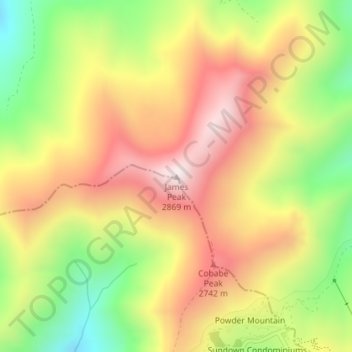
Name: James Peak topographic map, elevation, terrain.

Location: James Peak, Cache County, Utah, United States (41.39137 -111.79297 41.39147 -111.79287)

Average elevation: 8,366 ft

Minimum elevation: 7,241 ft

Maximum elevation: 9,380 ft

Cache County trails, hiking, mountain biking, running and outdoor activities

Other topographic maps

Click on a map to view its topography, its elevation and its terrain.

Lewiston

United States > Utah > Cache County

Average elevation: 4,514 ft

Trenton

United States > Utah > Cache County

Average elevation: 4,567 ft

Peter

United States > Utah > Cache County > Petersboro

Average elevation: 4,741 ft

Clarkston

United States > Utah > Cache County

The townsite of Clarkston was laid out in 1864. It was named for Israel Justus Clark, who was an early settler and the first branch president of the Church of Jesus Christ of Latter-day Saints in Clarkston. The settlers originally settled east of modern-day Clarkston in a spot known as the flat. Due to water…

Average elevation: 4,915 ft

Hyrum

United States > Utah > Cache County

Average elevation: 4,721 ft

Benson

United States > Utah > Cache County

Average elevation: 4,731 ft

River Heights

United States > Utah > Cache County

Average elevation: 4,577 ft

Mendon

United States > Utah > Cache County

Average elevation: 4,590 ft

Nibley

United States > Utah > Cache County

Average elevation: 4,685 ft

Logan River

United States > Utah > Cache County

Average elevation: 6,296 ft

Wellsville

United States > Utah > Cache County

Average elevation: 5,069 ft

Hyde Park

United States > Utah > Cache County

Average elevation: 4,652 ft

Providence

United States > Utah > Cache County

Average elevation: 4,705 ft