
Kota Pasuruan topographic map
Interactive map
Click on the map to display elevation.
About this map
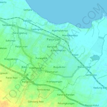
Name: Kota Pasuruan topographic map, elevation, terrain.
Location: Kota Pasuruan, East Java, Java, Indonesia (-7.68627 112.86827 -7.61583 112.95276)
Average elevation: 23 ft
Minimum elevation: -3 ft
Maximum elevation: 89 ft
Other topographic maps
Click on a map to view its topography, its elevation and its terrain.
Blau Timur
Indonesia > East Java > Kabupaten Malang > Dsn. Blau Ds. Permanu Kec. Pakisaji, Malang
Average elevation: 1,467 ft