
Bezirk Bruck-Mürzzuschlag topographic map
Interactive map
Click on the map to display elevation.
About this map
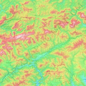
Name: Bezirk Bruck-Mürzzuschlag topographic map, elevation, terrain.
Location: Bezirk Bruck-Mürzzuschlag, Styria, Austria (47.30776 14.93149 47.82789 15.86234)
Average elevation: 3,304 ft
Minimum elevation: 1,365 ft
Maximum elevation: 7,365 ft
Other topographic maps
Click on a map to view its topography, its elevation and its terrain.
Sankt Martha
Austria > Styria > Bezirk Murtal > Sankt Marein-Feistritz > Sankt Martha
Average elevation: 2,444 ft
Hofkirchen bei Hartberg
Austria > Styria > Bezirk Hartberg-Fürstenfeld > Hofkirchen bei Hartberg
Average elevation: 1,335 ft