
Flowery Branch topographic map
Interactive map
Click on the map to display elevation.
About this map
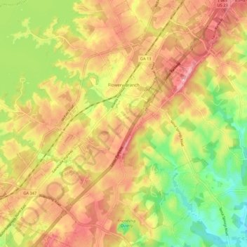
Name: Flowery Branch topographic map, elevation, terrain.
Location: Flowery Branch, Hall County, Georgia, 30542, United States (34.12683 -83.95920 34.21538 -83.88169)
Average elevation: 1,125 ft
Minimum elevation: 850 ft
Maximum elevation: 1,352 ft
Hall County trails, hiking, mountain biking, running and outdoor activities
Other topographic maps
Click on a map to view its topography, its elevation and its terrain.