
Bloomington topographic map
Interactive map
Click on the map to display elevation.
About this map
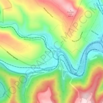
Name: Bloomington topographic map, elevation, terrain.
Location: Bloomington, Garrett County, Maryland, 21523, United States (39.46009 -79.09114 39.50009 -79.05114)
Average elevation: 1,430 ft
Minimum elevation: 899 ft
Maximum elevation: 2,159 ft
Garrett County trails, hiking, mountain biking, running and outdoor activities
Other topographic maps
Click on a map to view its topography, its elevation and its terrain.
Deep Creek Lake Natural Resource Management Area
United States > Maryland > Garrett County > McHenry
Average elevation: 2,602 ft