
Hudson Bend topographic map
Interactive map
Click on the map to display elevation.
About this map
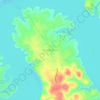
Name: Hudson Bend topographic map, elevation, terrain.
Location: Hudson Bend, Travis County, Texas, 78734, United States (30.39681 -97.94963 30.43681 -97.90963)
Average elevation: 722 ft
Minimum elevation: 650 ft
Maximum elevation: 922 ft
Travis County trails, hiking, mountain biking, running and outdoor activities
Other topographic maps
Click on a map to view its topography, its elevation and its terrain.
Walnut Creek Metropolitan Park
United States > Texas > Travis County > Austin
Average elevation: 702 ft
Mary Moore Searight zMetropolitan Park
United States > Texas > Travis County > Austin
Average elevation: 659 ft