
Hudson Bend topographic map
Interactive map
Click on the map to display elevation.
About this map
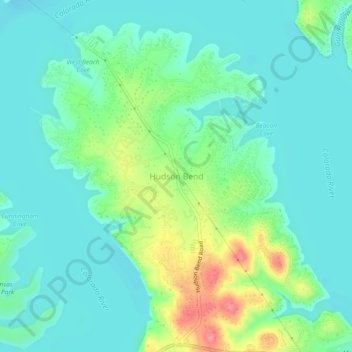
Name: Hudson Bend topographic map, elevation, terrain.
Location: Hudson Bend, Travis County, Texas, 78734, United States (30.39681 -97.94963 30.43681 -97.90963)
Average elevation: 722 ft
Minimum elevation: 650 ft
Maximum elevation: 922 ft
Other topographic maps
Click on a map to view its topography, its elevation and its terrain.
Austin
United States > Texas > Travis County
Austin, Travis County, Texas, United States
Average elevation: 709 ft
Lago Vista
United States > Texas > Travis County
Lago Vista, Travis County, Texas, United States
Average elevation: 823 ft
Hamilton Pool
United States > Texas > Travis County
Hamilton Pool, Travis County, Texas, United States
Average elevation: 902 ft
Lake Travis
United States > Texas > Travis County > Lago Vista
Lake Travis, Lago Vista, Travis County, Texas, United States
Average elevation: 912 ft
Pflugerville
United States > Texas > Travis County
Pflugerville, Travis County, Texas, United States
Average elevation: 705 ft
Shingle Hills
United States > Texas > Travis County
Shingle Hills, Travis County, Texas, 78620, United States
Average elevation: 1,253 ft
Pace Bend Park
United States > Texas > Travis County
Pace Bend Park, Travis County, Texas, United States
Average elevation: 735 ft
Austin
United States > Texas > Travis County
Austin, Travis County, Texas, 78701, United States
Average elevation: 666 ft
Hill of Life Falls
United States > Texas > Travis County > Austin
Hill of Life Falls, Austin, Travis County, Texas, 78735, United States
Average elevation: 764 ft
Walnut Creek Metropolitan Park
United States > Texas > Travis County > Austin
Walnut Creek Metropolitan Park, Austin, Travis County, Texas, United States
Average elevation: 702 ft
Bee Cave
United States > Texas > Travis County
Bee Cave, Travis County, Texas, United States
Average elevation: 886 ft
Cele
United States > Texas > Travis County
Cele, Travis County, Texas, United States
Average elevation: 597 ft
East Boggy Creek Greenbelt
United States > Texas > Travis County > Austin
East Boggy Creek Greenbelt, Austin, Travis County, Texas, United States
Average elevation: 472 ft
Hornsby Bend
United States > Texas > Travis County
Hornsby Bend, Travis County, Texas, 78725, United States
Average elevation: 449 ft
Lady Bird Lake
United States > Texas > Travis County > Austin
Lady Bird Lake, Austin, Travis County, Texas, United States
Average elevation: 561 ft
Mustang Ridge
United States > Texas > Travis County
Mustang Ridge, Travis County, Texas, United States
Average elevation: 614 ft
Jonestown
United States > Texas > Travis County
Jonestown, Travis County, Texas, United States
Average elevation: 906 ft
Gus Fruh Park
United States > Texas > Travis County > Austin
Gus Fruh Park, Austin, Travis County, Texas, 78704, United States
Average elevation: 636 ft
Plateau
United States > Texas > Travis County
Plateau, Travis County, Texas, 78732, United States
Average elevation: 751 ft
Zilker Park
United States > Texas > Travis County > Austin
Zilker Park, Austin, Travis County, Texas, 78746, United States
Average elevation: 512 ft
Mayfield Park
United States > Texas > Travis County > Austin
Mayfield Park, Austin, Travis County, Texas, United States
Average elevation: 591 ft
Shoal Creek
United States > Texas > Travis County > Austin
Shoal Creek, Austin, Travis County, Texas, 78731:78759, United States
Average elevation: 781 ft
St. Edwards Park
United States > Texas > Travis County
St. Edwards Park, Travis County, Texas, United States
Average elevation: 830 ft
Boggy Creek
United States > Texas > Travis County > Austin
Boggy Creek, M Station Apartments, Austin, Travis County, Texas, 78722, United States
Average elevation: 568 ft
Colorado River
United States > Texas > Travis County > Austin
Colorado River, Austin, Travis County, Texas, 78732, United States
Average elevation: 689 ft
West Lake Hills
United States > Texas > Travis County
West Lake Hills, Travis County, Texas, 78746, United States
Average elevation: 751 ft
Lakeway
United States > Texas > Travis County
Lakeway, Travis County, Texas, United States
Average elevation: 860 ft
Walter E Long Lake
United States > Texas > Travis County > Austin
Walter E Long Lake, Austin, Travis County, Texas, United States
Average elevation: 577 ft
Rollingwood
United States > Texas > Travis County
Rollingwood, Travis County, Texas, United States
Average elevation: 577 ft
Mount Bonnell
United States > Texas > Travis County > Austin
Mount Bonnell, Austin, Travis County, Texas, 78731, United States
Average elevation: 620 ft
Pilot Knob
United States > Texas > Travis County
Pilot Knob, Travis County, Texas, 78719, United States
Average elevation: 545 ft
Dick Nichols District Park
United States > Texas > Travis County > Austin
Dick Nichols District Park, 8011, Austin, Travis County, Texas, 78749, United States
Average elevation: 807 ft
Mabel Davis District Park
United States > Texas > Travis County > Austin
Mabel Davis District Park, Austin, Travis County, Texas, United States
Average elevation: 627 ft
Barton Creek Greenbelt -- Gus Fruh Access
United States > Texas > Travis County > Austin
Barton Creek Greenbelt -- Gus Fruh Access, Horseshoe Bend, Austin, Travis County, Texas, 78704, United States
Average elevation: 630 ft
Mary Moore Searight zMetropolitan Park
United States > Texas > Travis County > Austin
Mary Moore Searight zMetropolitan Park, Austin, Travis County, Texas, United States
Average elevation: 659 ft
Manor
United States > Texas > Travis County
Manor, Travis County, Texas, 78653, United States
Average elevation: 561 ft
West Lake Hills
United States > Texas > Travis County > West Lake Hills > West Lake Hills
West Lake Hills, Travis County, Texas, 78746, United States
Average elevation: 699 ft
Onion Creek
United States > Texas > Travis County > Austin
Onion Creek, Austin, Travis County, Texas, 78744, United States
Average elevation: 535 ft
Briarcliff
United States > Texas > Travis County
Briarcliff, Travis County, Texas, United States
Average elevation: 833 ft
Barton Creek
United States > Texas > Travis County
Barton Creek, Travis County, Texas, 78735, United States
Average elevation: 810 ft
Walnut Creek
United States > Texas > Travis County > Austin
Walnut Creek, Austin, Travis County, Texas, 78753, United States
Average elevation: 640 ft
Longview Neighborhood Park
United States > Texas > Travis County > Austin
Longview Neighborhood Park, Austin, Travis County, Texas, 78745, United States
Average elevation: 768 ft
Cat Mountain
United States > Texas > Travis County > Austin
Cat Mountain, Austin, Travis County, Texas, 78731, United States
Average elevation: 679 ft
Volente
United States > Texas > Travis County > Volente
Volente, Travis County, Texas, United States
Average elevation: 817 ft
Royal Pointe Park
United States > Texas > Travis County > Pflugerville
Royal Pointe Park, Spring Trails, Pflugerville, Travis County, Texas, United States
Average elevation: 778 ft
Gregg
United States > Texas > Travis County > Gregg
Gregg, Travis County, Texas, United States
Average elevation: 614 ft
Creedmoor
United States > Texas > Travis County > Creedmoor
Creedmoor, Travis County, Texas, United States
Average elevation: 663 ft
Webberville
United States > Texas > Travis County
Webberville, Travis County, Texas, United States
Average elevation: 410 ft
Tarrytown Neighborhood Park
United States > Texas > Travis County > Austin
Tarrytown Neighborhood Park, Old West Austin, Austin, Travis County, Texas, United States
Average elevation: 587 ft
Mount Barker
United States > Texas > Travis County > Austin
Mount Barker, Austin, Travis County, Texas, 78731, United States
Average elevation: 633 ft