
Dacono topographic map
Interactive map
Click on the map to display elevation.
About this map
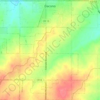
Name: Dacono topographic map, elevation, terrain.
Location: Dacono, Weld County, Colorado, 80514, United States (40.03305 -104.98172 40.08798 -104.91447)
Average elevation: 5,079 ft
Minimum elevation: 4,970 ft
Maximum elevation: 5,187 ft
Weld County trails, hiking, mountain biking, running and outdoor activities
Other topographic maps
Click on a map to view its topography, its elevation and its terrain.
Greeley
United States > Colorado > Weld County > Greeley > Greeley
Greeley experiences a semi-arid climate (Köppen BSk). High temperatures are generally around 90–95 °F (32 °C) in the summer and 40-45 °F (4 °C) in the winter, although significant variation occurs. The hottest days generally occur around the third week of July and the coldest in January. Nighttime lows…
Average elevation: 4,783 ft