
Lake County topographic map
Interactive map
Click on the map to display elevation.
Lake County
Ridges on the Lake Plain physiographic region, and on which some roads are laid, are beaches formed by the various glacial lakes which occurred as the glaciers receded. Lake Maumee was the highest glacial lake at about 760 feet, and left Maumee II beach. Whittlesey beach, formed by Lake Whittlesey at 740 feet, is known as South Ridge. Arkona beach (Lake Arkona) is Middle Ridge, and occurs at about 690 feet. North Ridge is the remnant of Warren beach (Lake Warren), at an elevation of 685 feet. Elkton beach is the northernmost ridge, at 625 feet, an occurred at the time of Lake Elkton. Lake Shore Boulevard follows Elkton beach in Mentor Township.
About this map
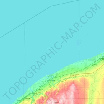
Name: Lake County topographic map, elevation, terrain.
Location: Lake County, Ohio, United States (41.56967 -81.48869 42.24697 -81.00256)
Average elevation: 643 ft
Minimum elevation: 558 ft
Maximum elevation: 1,348 ft
Ohio trails, hiking, mountain biking, running and outdoor activities
Other topographic maps
Click on a map to view its topography, its elevation and its terrain.
Columbus
United States > Ohio > Franklin County > Columbus
The confluence of the Scioto and Olentangy rivers is just north-west of Downtown Columbus. Several smaller tributaries course through the Columbus metropolitan area, including Alum Creek, Big Walnut Creek, and Darby Creek. Columbus is considered to have relatively flat topography thanks to a large glacier that…
Average elevation: 837 ft
French Park
United States > Ohio > Hamilton County > Amberley Village > Rolling Knolls Estate
Average elevation: 771 ft
Pine Ridge Trailer Park
United States > Ohio > Lorain County > North Ridgeville
Average elevation: 748 ft
Nature Center at The Summit
United States > Ohio > Hamilton County > Cincinnati
Average elevation: 568 ft
Cincinnati
United States > Ohio > Hamilton County
Cincinnati has several standard modes of transportation including sidewalks, roads, public transit, bicycle paths and airports. The city's hills preclude the regular street grid common to many cities built up in the 19th century, and outside of the downtown basin, regular street grids are rare except for in…
Average elevation: 738 ft