
Montérégie topographic map
Interactive map
Click on the map to display elevation.
About this map
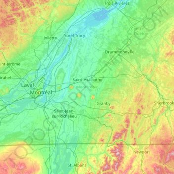
Name: Montérégie topographic map, elevation, terrain.
Location: Montérégie, Quebec, Canada (44.99137 -74.66850 46.11347 -72.31555)
Average elevation: 515 ft
Minimum elevation: 3 ft
Maximum elevation: 3,415 ft
Other topographic maps
Click on a map to view its topography, its elevation and its terrain.
Grande-Cascapédia
Canada > Quebec > Bonaventure (MRC) > Cascapédia-Saint-Jules
Average elevation: 157 ft
Mount Royal Park
Canada > Quebec > Urban agglomeration of Montreal > Montreal
The mountain is part of the Monteregian Hills situated between the Laurentians and the Appalachian Mountains. It gave its Latin name, Mons Regius, to the Monteregian chain. The mountain consists of three peaks: Colline de la Croix (or Mont Royal proper) at 233 m (764 ft), Colline d'Outremont (or Mount Murray,…
Average elevation: 361 ft
Quebec
Canada > Quebec > Urban agglomeration of Québec
Quebec City was built on the north bank of the Saint Lawrence River, where it narrows and meets the mouth of the Saint-Charles River. Old Quebec is located on top and at the foot of Cap-Diamant, which is on the eastern edge of a plateau called the promontory of Quebec (Quebec hill). Because of this topographic…
Average elevation: 328 ft
Galerie d'amenée d'eau, Manic-5
Canada > Quebec > Manicouagan > Rivière-aux-Outardes
Average elevation: 1,112 ft
Mount Royal
Canada > Quebec > Urban agglomeration of Montreal > Montreal
The hill is part of the Monteregian Hills situated between the Laurentians and the Appalachian Mountains. It gave its Latin name, Mons Regius, to the Monteregian chain. The hill consists of three peaks: Colline de la Croix (or Mont Royal proper) at 233 m (764 ft), Colline d'Outremont (or Mount Murray, in the…
Average elevation: 364 ft
Parc Marie-Claire-Kirkland-Casgrain
Canada > Quebec > Urban agglomeration of Montreal > Montreal
Average elevation: 79 ft
Hemmingford
Canada > Quebec > Les Jardins-de-Napierville > Hemmingford (village)
Average elevation: 233 ft
Saint-Adolphe
Canada > Quebec > La Jacques-Cartier > Stoneham-et-Tewkesbury > Saint-Adolphe
Average elevation: 1,572 ft
Club de Plein Air Saint Adolphe d'Howard
Canada > Quebec > Les Pays-d'en-Haut > Saint-Adolphe-d'Howard
Average elevation: 1,309 ft