Geolocate

Mashteuiatsh topographic map

Click on the map to display elevation.

About this map

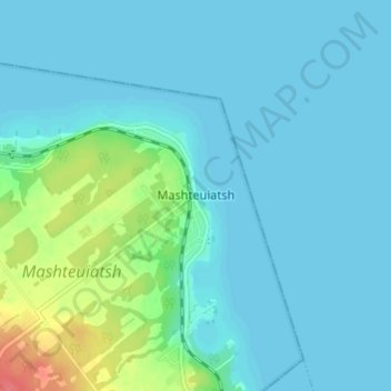
Name: Mashteuiatsh topographic map, elevation, terrain.

Location: Mashteuiatsh, Saguenay–Lac-Saint-Jean, Quebec, G0W 2H0, Canada (48.55591 -72.24877 48.59591 -72.20877)

Average elevation: 348 ft

Minimum elevation: 315 ft

Maximum elevation: 505 ft

Other topographic maps

Click on a map to view its topography, its elevation and its terrain.

Saint-Zacharie

Canada > Quebec > Les Etchemins

Average elevation: 1,490 ft

Milan

Canada > Quebec > Le Granit

Average elevation: 1,598 ft

Trois-Rivières

Canada > Quebec

Average elevation: 118 ft

Saint-Michel-des-Saints

Canada > Quebec > Matawinie

Average elevation: 1,496 ft

Beauce

Canada > Quebec > Beauce-Sartigan

Average elevation: 1,237 ft

Lac Clair

Canada > Quebec > Matawinie > Rawdon

Average elevation: 1,070 ft

Saint-Malo

Canada > Quebec > Coaticook (MRC)

Saint-Malo (local pronunciation) is a municipality in Quebec, Canada, on the Canada–United States border. Saint-Malo has the highest elevation of any municipality in Quebec. At 640 metres (2,100 ft), local residents live in an environment of forests, farms, and waterways that supply their livelihood.

Average elevation: 1,588 ft

Entrelacs

Canada > Quebec > Matawinie

Average elevation: 1,411 ft

Lac-des-Plages

Canada > Quebec > Papineau

Average elevation: 935 ft

Lac Levesque

Canada > Quebec > Les Laurentides > Lac-Supérieur

Average elevation: 1,194 ft

Lac Nick

Canada > Quebec > Memphrémagog > Bolton-Est

Average elevation: 919 ft

Cap-Santé

Canada > Quebec > Portneuf (MRC)

Average elevation: 161 ft

Lac des Îles

Canada > Quebec > Rouyn-Noranda

Average elevation: 1,289 ft

Litchfield

Canada > Quebec > Pontiac

Average elevation: 571 ft

Cayamant

Canada > Quebec > La Vallée-de-la-Gatineau

Average elevation: 814 ft

Lac Caya

Canada > Quebec > La Vallée-de-la-Gatineau > Bouchette

Average elevation: 653 ft

Amos

Canada > Quebec > Abitibi

Average elevation: 1,027 ft

Lac Grand

Canada > Quebec > La Côte-de-Beaupré > Lac-Jacques-Cartier

Average elevation: 1,854 ft

Lac-Beauport

Canada > Quebec > La Jacques-Cartier

Average elevation: 1,161 ft

Chartierville

Canada > Quebec > Le Haut-Saint-François

Average elevation: 1,939 ft

Shawville

Canada > Quebec > Pontiac

Average elevation: 561 ft

Sainte-Luce

Canada > Quebec > La Mitis

Average elevation: 125 ft

Sainte-Françoise

Canada > Quebec > Bécancour (MRC)

Average elevation: 289 ft

Brome-Missisquoi

Canada > Quebec

Average elevation: 597 ft

Saint Lawrence River

Canada > Quebec > Montreal

Average elevation: 46 ft

Sainte-Rose-de-Watford

Canada > Quebec > Les Etchemins

Average elevation: 1,214 ft

Val-d'Or

Canada > Quebec > La Vallée-de-l'Or

Val-d'Or is situated on the Canadian Shield at an elevation of 1100 feet (330m) above sea level. Although its name refers to a valley ("Val"), the city is actually situated on a vast, slightly undulating plain.

Average elevation: 1,086 ft

Kamouraska (MRC)

Canada > Quebec

Average elevation: 820 ft

Notre-Dame-de-Lourdes

Canada > Quebec > Joliette (MRC)

Average elevation: 259 ft

Saint-Félicien

Canada > Quebec > Le Domaine-du-Roy

Average elevation: 463 ft

Mont-Joli

Canada > Quebec > La Mitis

Average elevation: 207 ft

Capitale-Nationale

Canada > Quebec

Average elevation: 1,230 ft

Brigham

Canada > Quebec > Brome-Missisquoi

Average elevation: 315 ft

Acton

Canada > Quebec

Average elevation: 433 ft

Lac Maria

Canada > Quebec > La Côte-de-Beaupré > Lac-Jacques-Cartier

Average elevation: 2,477 ft

Black and White

Canada > Quebec > Les Laurentides > Montcalm

Average elevation: 974 ft

Maria

Canada > Quebec > Avignon

Average elevation: 338 ft

René-Levasseur Island

Canada > Quebec > Manicouagan

Average elevation: 1,555 ft

Hudson

Canada > Quebec > Vaudreuil-Soulanges

Average elevation: 184 ft

Rosemère

Canada > Quebec > Thérèse-De Blainville

Average elevation: 121 ft

Wickham

Canada > Quebec > Drummond

Average elevation: 341 ft

Lac Maton

Canada > Quebec > La Vallée-de-la-Gatineau > Lac-Pythonga

Average elevation: 1,302 ft

Lacs Roger

Canada > Quebec > Maria-Chapdelaine > Passes-Dangereuses

Average elevation: 1,253 ft

Otter Lake

Canada > Quebec > Pontiac

Average elevation: 860 ft

Réserve faunique La Vérendrye

Canada > Quebec

Average elevation: 1,214 ft

Chapais

Canada > Quebec > Jamésie

Average elevation: 1,257 ft

Lac Forant

Canada > Quebec > Pontiac > Lac-Nilgaut

Average elevation: 935 ft

Rawdon

Canada > Quebec > Matawinie

Average elevation: 646 ft

Lac Genève

Canada > Quebec > Jamésie

Average elevation: 1,348 ft

Lac Emro

Canada > Quebec > Pontiac > Lac-Nilgaut

Average elevation: 1,020 ft

Bas-Saint-Laurent

Canada > Quebec

The topography of Bas-Saint-Laurent has two main elements : the plateaus of the Appalachian Mountains, called Notre Dame Mountains, and the lowlands in the fine stripe of land along the Saint Lawrence river. These are separated by an intermediate area of ridges and foothills which meld with the plateaus. The…

Average elevation: 935 ft

Lac-Jacques-Cartier

Canada > Quebec > La Côte-de-Beaupré

Average elevation: 2,333 ft

Low

Canada > Quebec > La Vallée-de-la-Gatineau

Average elevation: 722 ft

Saint-Janvier-de-Joly

Canada > Quebec > Lotbinière (MRC)

Average elevation: 384 ft

Lac Suffolk

Canada > Quebec > Papineau > Boileau

Average elevation: 883 ft

Pingualuit Crater

Canada > Quebec > Kativik > Rivière-Koksoak

Average elevation: 1,765 ft

Big Black River

Canada > Quebec > L'Islet (MRC) > Saint-Marcel

Average elevation: 1,260 ft

Lac-Brome

Canada > Quebec > Brome-Missisquoi

Average elevation: 866 ft

Baie-Comeau

Canada > Quebec > Manicouagan

Average elevation: 341 ft

Auclair

Canada > Quebec > Témiscouata > Auclair

Average elevation: 899 ft

Eastman

Canada > Quebec > Memphrémagog

Average elevation: 1,030 ft

Bécancour

Canada > Quebec > Bécancour (MRC)

Average elevation: 128 ft

Papineauville

Canada > Quebec > Papineauville

Average elevation: 456 ft

Labelle

Canada > Quebec > Les Laurentides

Average elevation: 1,004 ft

Cacouna

Canada > Quebec > Cacouna

Average elevation: 89 ft

Réserve faunique Rouge-Matawin

Canada > Quebec

Average elevation: 1,555 ft

Moore Creek

Canada > Quebec > Pontiac (MRC) > Otter Lake

Average elevation: 830 ft

Mont-Saint-Pierre

Canada > Quebec > La Haute-Gaspésie

Average elevation: 1,096 ft

Dorval

Canada > Quebec > Urban agglomeration of Montreal

Average elevation: 95 ft

Ville-Marie

Canada > Quebec > Ville-Marie

Average elevation: 725 ft

Beauport

Canada > Quebec > Quebec City

Average elevation: 568 ft

Gatineau

Canada > Quebec > Gatineau

Average elevation: 351 ft

Saint Lawrence River

Canada > Quebec > L'Islet

Average elevation: 906 ft

Escuminac

Canada > Quebec > Avignon

Average elevation: 364 ft

Colombier

Canada > Quebec > La Haute-Côte-Nord > Colombier

Average elevation: 226 ft

Terrebonne

Canada > Quebec > Les Moulins

Average elevation: 135 ft

Papineau

Canada > Quebec

Average elevation: 761 ft

Saint-Hippolyte

Canada > Quebec > La Rivière-du-Nord

Average elevation: 892 ft

New Richmond

Canada > Quebec > Bonaventure

Average elevation: 276 ft

Anticosti Island

Canada > Quebec > Minganie > Anticosti Island

Average elevation: 98 ft

Lac Whitton

Canada > Quebec > Le Granit > Nantes

Average elevation: 1,621 ft

Boileau

Canada > Quebec > Papineau > Boileau

Average elevation: 827 ft

Gear up for your next adventure:

📡GPS Antenna Upgrade - Enhance GPS reception in remote terrain
🪶Survival Guide Book - Expert advice for emergency preparedness
🪶Wildlife Field Guides - Learn animal tracking and species ID
📦Dry Bags Set - Waterproof storage for electronics and clothes
🔭Telescopic Hiking Pole - Adjustable pole for hiking stability

As an Amazon Associate, this site earns from qualifying purchases at no extra cost to you.