
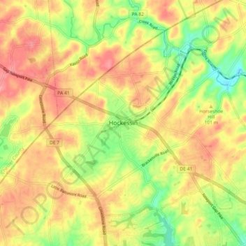
Hockessin, Delaware topographic map
Interactive map
Click on the map to display elevation.
About this map
Name: Hockessin, Delaware topographic map, elevation, terrain.
Average elevation: 315 ft
Minimum elevation: 135 ft
Maximum elevation: 459 ft
New Castle County trails, hiking, mountain biking, running and outdoor activities
Other topographic maps
Click on a map to view its topography, its elevation and its terrain.
Penn Acres South
United States > Delaware > New Castle County > Wilmington Manor
Average elevation: 39 ft
Fort DuPont State Park
United States > Delaware > New Castle County > Delaware City
Average elevation: 7 ft
Wilmington
United States > Delaware > New Castle County > Wilmington
On the western side of Market Street, the Piedmont topography is rocky and hilly, rising to a point that marks the watershed between the Brandywine River and the Christina River. This watershed line runs along Delaware Avenue westward from 10th Street and Market Street.
Average elevation: 141 ft
Bellefonte
United States > Delaware > New Castle County > Bellefonte > KynLyn Apartments
Average elevation: 115 ft
Ebright Azimuth
United States > Delaware > New Castle County
The Ebright Azimuth is the point with the highest benchmark monument elevation in the U.S. state of Delaware. It is marked with a geodetic benchmark monument and has an elevation of 447.85 feet (136.50 m) above sea level. The only state high-point with a lower elevation is Britton Hill in the state of Florida…
Average elevation: 407 ft
Christiana Acres
United States > Delaware > New Castle County > Christiana Acres
Average elevation: 33 ft
Dobbinsville
United States > Delaware > New Castle County > New Castle > Dobbinsville
Average elevation: 13 ft
Loveville
United States > Delaware > New Castle County > Hockessin, Delaware > Loveville
Average elevation: 279 ft
South Saint Georges
United States > Delaware > New Castle County > South Saint Georges
Average elevation: 36 ft
Auburn Hills
United States > Delaware > New Castle County > Hockessin, Delaware > Auburn Hills
Average elevation: 312 ft