
Salta topographic map
Interactive map
Click on the map to display elevation.
Salta
Although Salta Province is located near the Tropic of Capricorn, it has a wide range of climates due to variation in altitude and the influence of orography. The orientation of the Andes influences the distribution of precipitation within the province.
About this map
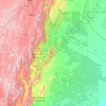
Name: Salta topographic map, elevation, terrain.
Location: Salta, Argentina (-26.41670 -68.56789 -21.99877 -62.33923)
Average elevation: 5,348 ft
Minimum elevation: 341 ft
Maximum elevation: 20,328 ft
Other topographic maps
Click on a map to view its topography, its elevation and its terrain.
Colomé
Colomé is a village and rural municipality in Salta Province in northwestern Argentina. It is located about 20 km from Molinos, Salta. This settlement was established by the last Spanish governor of Salta, Nicolás Severo de Isasmendi, in 1831. His daughter Ascención imported grapevines from France and…
Average elevation: 7,520 ft
Las Leñas
Argentina > Mendoza > Distrito Ciudad de Malargüe
Las Leñas is a ski resort in Argentina, located in the western part of Mendoza Province. It has reliable powder snow and climate for extreme and off-piste skiing. Construction of the ski center began January 1983, and by July 1983, it opened with a 300 bed hotel. The ski area has a good diversity of slopes…
Average elevation: 7,851 ft
San Juan
San Juan is ranked second among the wine-producing provinces of Argentina. It has a cultivated area of 116,700 acres at altitudes of between 1,970 (601m) and 4,590 feet (1399m) above sea level. This region specializes in Syrah, Malbec, Cabernet Sauvignon, Bonarda, Chardonnay and Torrontés. Because of this…
Average elevation: 2,277 ft
Andes
Argentina > Mendoza > Distrito Las Cuevas
The Andes Mountains are the highest mountain range outside Asia. The highest mountain outside Asia, Argentina's Mount Aconcagua, rises to an elevation of about 6,961 m (22,838 ft) above sea level. The peak of Chimborazo in the Ecuadorian Andes is farther from the Earth's center than any other location on the…
Average elevation: 20,367 ft
Aconcagua
Argentina > Mendoza > Distrito Las Cuevas
Aconcagua (Spanish pronunciation: [akoŋˈkaɣwa]) is a mountain in the Principal Cordillera of the Andes mountain range, in Mendoza Province, Argentina. It is the highest mountain in the Americas, the highest outside Asia, and the highest in the Southern Hemisphere with a summit elevation of 6,961 metres…
Average elevation: 20,344 ft
Cordoba
Argentina > Córdoba > Pedanía Capital
The wealthier suburbs west of the city are located at slightly higher altitudes, which allows cool breezes to blow in the summer, bringing drier, comfortable nights during hotter periods, and more regular frost in the winter. Generally speaking, Córdoba's daytime temperatures are very slightly warmer than…
Average elevation: 1,499 ft
Aconcagua
Argentina > Mendoza > Distrito Las Cuevas
Aconcagua (Spanish pronunciation: [akoŋˈkaɣwa]) is a mountain in the Principal Cordillera of the Andes mountain range, in Mendoza Province, Argentina. It is the highest mountain in the Americas, the highest outside Asia, and the highest in the Southern Hemisphere with a summit elevation of 6,961 metres…
Average elevation: 20,344 ft
Piedra del Águila
Argentina > Neuquén Province > Municipio de Piedra del Águila
Average elevation: 1,768 ft
José León Suárez
Argentina > Buenos Aires > José León Suárez > José León Suárez
Average elevation: 56 ft
Payún Matrú
Argentina > Mendoza > Distrito Agua Escondida
Payún Matrú lies in the Malargüe Department of the Mendoza Province, in Argentina. The area is inhospitable due to the lack of usable water and high elevation. Nevertheless, there are many paved roads such as National Route 40 which passes west of the field, and National Route 186 which runs around its…
Average elevation: 11,358 ft
Cerro Risco Plateado
Argentina > Mendoza > Distrito Ciudad de Malargüe
Risco Plateado is a stratovolcano in Argentina, with an elevation of 4,999 metres (16,401 ft) above sea level. With a prominence of 1,602 metres (5,256 ft), it is one of the many ultra prominent peaks in the Andes. The equilibrium line altitude of the volcano lies at an altitude of 3,800 metres (12,500 ft).
Average elevation: 14,383 ft
Ingeniero Maschwitz
Argentina > Buenos Aires > Ingeniero Maschwitz > Ingeniero Maschwitz
Average elevation: 33 ft
Falda del Carmen
Argentina > Córdoba > Pedanía Lagunilla > Falda del Carmen
Average elevation: 2,172 ft
Luján de Cuyo
Argentina > Mendoza > Departamento Luján de Cuyo > Luján de Cuyo
Average elevation: 3,094 ft
Concepción del Uruguay
Argentina > Entre Ríos Province > Distrito Molino > Concepción del Uruguay
Average elevation: 30 ft