
Los Angeles County topographic map
Interactive map
Click on the map to display elevation.
Los Angeles County
Los Angeles County's topography is characterized by a diverse landscape that includes coastal plains, mountain ranges, and expansive valleys. The county is situated within the Los Angeles Basin, a large sedimentary basin bounded by the Santa Monica Mountains to the north and the San Gabriel Mountains to the east. These mountain ranges feature elevations reaching up to approximately 10,000 feet (3,048 meters) in certain areas. The county's terrain also encompasses the San Fernando Valley, a significant flat area, and the Santa Clarita Valley, both of which are surrounded by various mountain ranges. Additionally, the county's coastline along the Pacific Ocean features cliffs and beaches, contributing to its varied topographical features.
About this map
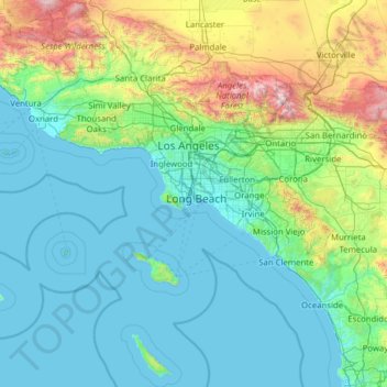
Name: Los Angeles County topographic map, elevation, terrain.
Location: Los Angeles County, California, United States (32.75004 -118.95172 34.82331 -117.64627)
Average elevation: 1,240 ft
Minimum elevation: -3 ft
Maximum elevation: 9,836 ft
California trails, hiking, mountain biking, running and outdoor activities
Other topographic maps
Click on a map to view its topography, its elevation and its terrain.
San Francisco Bay Area
United States > California > San Francisco
The San Francisco Bay Area is characterized by a diverse and dynamic topography shaped by geological processes over millions of years. This region features a combination of coastal plains, steep hills, and rugged mountains, all influenced by the tectonic activity associated with the nearby San Andreas Fault…
Average elevation: 371 ft
El Dorado Hills
United States > California > El Dorado County > Cameron Park
El Dorado Hills (EDH), as defined by the 2010 census-designated place (CDP), is at the western border of El Dorado County, between the City of Folsom and the unincorporated community of Cameron Park. The northern limits of the CDP are Folsom Lake and the South Fork of the American River, where river rafters…
Average elevation: 833 ft
San Diego
United States > California > San Diego County > San Diego
The climate in San Diego, like most of Southern California, often varies significantly over short geographical distances, resulting in microclimates. In San Diego, this is mostly because of the city's topography (the Bay, and the numerous hills, mountains, and canyons). Frequently, particularly during the "May…
Average elevation: 187 ft
Crescent City
United States > California > Del Norte County
The topography of the sea floor surrounding Crescent City has the effect of focusing tsunamis. According to researchers at Humboldt State University and the University of Southern California, the city experienced tsunami conditions 31 times between the years 1933 and 2008. Although many of these incidents were…
Average elevation: 102 ft
Oakhurst
United States > California > Madera County > Oakhurst
Oakhurst is located on the Fresno River 3 miles (5 km) south-southwest of Yosemite Forks, at an elevation of 2,274 feet (693 m). Its coordinates are 37°19′41″N 119°38′58″W / 37.32806°N 119.64944°W / 37.32806; -119.64944. It is located at the junction of state highways 41 and 49, at the…
Average elevation: 2,746 ft
Golden Gate Park
United States > California > San Francisco
In the 1860s, San Franciscans began to feel the need for a spacious public park similar to Central Park, which was then taking shape in New York City. Golden Gate Park was carved out of unpromising sand and shore dunes that were known as the Outside Lands, in an unincorporated area west of San Francisco's…
Average elevation: 233 ft
Santa Cruz Mountains
United States > California > Santa Clara County
The Santa Cruz Mountains are a region of great biological diversity, encompassing cool, moist coastal ecosystems as well as warm, dry chaparral. Much of the area in the Santa Cruz mountains is considered temperate rainforest. In valleys and moist ocean-facing slopes some of the southernmost coast redwoods…
Average elevation: 755 ft
San Jacinto Mountains
United States > California > Riverside County
The San Jacinto Mountains, like the neighboring San Bernardino Mountains, are a humid island above the surrounding desert and semi-desert. Annual precipitation ranges from about 15 inches at the western base (and only 6 inches on the eastern, desert base) to as much as 32 inches above 5,500 feet (the mountain…
Average elevation: 8,816 ft
Point Dume
United States > California > Los Angeles County > Malibu
Offshore, the nutrient-rich and frigid waters of the Pacific enhance the entire marine food web, from primary producers such as algae and zooplankton to apex predators like sand sharks, bottlenose dolphins, and gray whales. Within the Marine Protected Areas (MPAs), the diverse seafloor topography encompasses…
Average elevation: 39 ft
Devil Canyon
United States > California > San Bernardino County > San Bernardino
Average elevation: 2,060 ft
Portuguese Bend
United States > California > Los Angeles County > Rancho Palos Verdes
Average elevation: 217 ft
Fort Irwin
United States > California > San Bernardino County
Fort Irwin National Training Center (Fort Irwin NTC) is a major training area for the United States military in the Mojave Desert in northern San Bernardino County, California. Fort Irwin is at an average elevation of 2,454 feet (748 m). It is located 37 miles (60 km) northeast of Barstow, in the Calico…
Average elevation: 2,539 ft
May Van Canyon Artesian Well
United States > California > San Bernardino County
Average elevation: 7,779 ft
Aguanga
United States > California > Riverside County
Aguanga (/əˈwɑːŋ.ɡə/; Luiseño: Awáanga, meaning "dog place") is a census-designated place located within the Inland Empire in Riverside County, California. It is located about 18 miles (29 km) east of Temecula and 22 miles (35 km) south-southeast of Hemet. Aguanga lies at an elevation of 1955 feet…
Average elevation: 2,156 ft
High Country
United States > California > San Bernardino County > Hesperia
Average elevation: 3,622 ft
Mount Shasta
United States > California > Siskiyou County
Mount Shasta (Shasta: Waka-nunee-Tuki-wuki; Karuk: Úytaahkoo) is a potentially active volcano at the southern end of the Cascade Range in Siskiyou County, California. At an elevation of 14,179 feet (4,321.8 meters), it is the second-highest peak in the Cascades and the fifth-highest in the state. Mount Shasta…
Average elevation: 12,195 ft
Bolinas
United States > California > Marin County
Bolinas sits at an elevation of 36 feet (11 m) above sea level. It is bound on the northeast by Bolinas Lagoon and Kent Island, on the south by Bolinas Bay and Duxbury Point, on the southwest by the Pacific Ocean, and on the northwest by Point Reyes National Seashore. According to the United States Census…
Average elevation: 92 ft
San Fernando Valley
United States > California > Los Angeles County > Los Angeles
Average elevation: 1,627 ft
Cardiac Hill
United States > California > Contra Costa County > Pleasant Hill
Average elevation: 102 ft
Stirling City
United States > California > Butte County
Stirling City is a census-designated place in Butte County, California, located on Paradise Ridge in the western foothills of the Sierra Nevada. Contrary to its name, Stirling City is not a city. Its ZIP Code is 95978 and area code 530. It lies at an elevation of 3570 feet (1088 m). Stirling City had a…
Average elevation: 3,425 ft
Coachella Valley
United States > California > Riverside County > Palm Desert
The area is surrounded on the southwest by the Santa Rosa Mountains, by the San Jacinto Mountains to the west, the Little San Bernardino Mountains to the east and San Gorgonio Mountain to the north. These mountains peak at around 11,000 feet (3,400 m) and tend to average between 5,000 and 7,000 feet (1,500 and…
Average elevation: 236 ft
Desert Knolls Manor
United States > California > San Bernardino County > Apple Valley
Average elevation: 3,045 ft
Charlotte Lake
United States > California > Fresno County
Charlotte Lake (also known as Charlotta Lake, or Rhoda Lake) is a lake in the Sierra Nevada, located in Kings Canyon National Park, eastern Fresno County, California. The lake is located on the John Muir Trail, at an elevation of 10,544 feet (3,214 m).
Average elevation: 10,932 ft
Los Serranos
United States > California > San Bernardino County > Chino Hills
Average elevation: 696 ft
Running Springs
United States > California > San Bernardino County
Running Springs is a mountain community in the San Bernardino Mountains. It is an inholding in the San Bernardino National Forest. Situated at the junction of State Route 18 and State Route 330, it is a major gateway to the mountain communities of Lake Arrowhead, Arrowbear, Green Valley Lake, and Big Bear and…
Average elevation: 5,489 ft
Shumway Oak Grove Regional Park
United States > California > San Joaquin County > Stockton
Average elevation: 10 ft
Gerber
United States > California > Tehama County
Gerber is a census-designated place (CDP) in Tehama County, California. Gerber sits at an elevation of 226 feet (69 m). The 2020 United States census reported Gerber's population was 1,044.
Average elevation: 236 ft
Ramona
United States > California > San Diego County
In January 2006, Ramona Valley was designated the country's 162nd American Viticultural Area (AVA) by the Alcohol and Tobacco Tax and Trade Bureau, which recognized the area for its distinctive microclimate, elevation, and soil attributes.
Average elevation: 1,539 ft