
Province of Sandia topographic map
Interactive map
Click on the map to display elevation.
About this map
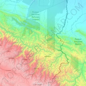
Name: Province of Sandia topographic map, elevation, terrain.
Location: Province of Sandia, Puno, 21101, Peru (-14.66193 -69.84857 -13.00413 -68.82668)
Average elevation: 5,607 ft
Minimum elevation: 627 ft
Maximum elevation: 19,711 ft
Other topographic maps
Click on a map to view its topography, its elevation and its terrain.
La Rinconada
The town has gained notoriety for its extreme living conditions that include its high rates of altitude sickness, pollution, poverty, murder, and sex trafficking, and as a result has sometimes been referred to in Spanish as la ciudad sin ley del Perú, which means "the lawless city of Peru".
Average elevation: 16,152 ft
La Rinconada
High in the Andes, La Rinconada has an alpine tundra climate (ET, according to the Köppen climate classification), with no month having mean temperatures even close to the 10 °C (50 °F) threshold that would permit tree growth and a subtropical highland classification for the city. Far above the tree line,…
Average elevation: 16,152 ft