
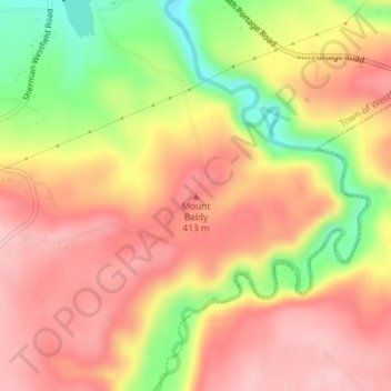
Mount Baldy topographic map
Interactive map
Click on the map to display elevation.
About this map
Name: Mount Baldy topographic map, elevation, terrain.
Average elevation: 1,207 ft
Minimum elevation: 853 ft
Maximum elevation: 1,424 ft
New York trails, hiking, mountain biking, running and outdoor activities
Other topographic maps
Click on a map to view its topography, its elevation and its terrain.
Cortland County
Cortland County features a varied topography characteristic of the glaciated Appalachian Plateau region. The landscape is primarily rural, with elevations ranging from approximately 850 to 2,100 feet above sea level. The terrain includes rolling hills, steep ridges, and valleys shaped by glacial activity,…
Average elevation: 1,486 ft
Town of Clifton Park
United States > New York > Saratoga County
Clifton Park features a predominantly gentle terrain characterized by rolling hills and a mixture of forested areas, open fields, and suburban developments. The elevation in this area varies, generally ranging from around 300 to 500 feet above sea level, contributing to a picturesque landscape that integrates…
Average elevation: 279 ft
Manhattan Island
United States > New York > New York
Marble Hill is one example of how Manhattan's land has been considerably altered by human intervention. The borough has seen substantial land reclamation along its waterfronts since Dutch colonial times, and much of the natural variation in its topography has been evened out.
Average elevation: 56 ft
Erie Canal
United States > New York > Erie County > City of Tonawanda
The construction of the Erie Canal was a landmark civil engineering achievement in the early history of the United States. When built, the 363-mile (584 km) canal was the second-longest in the world (after the Grand Canal in China). Initially 40 feet (12 m) wide and 4 feet (1.2 m) deep, the canal was expanded…
Average elevation: 581 ft
Washington Heights
United States > New York > New York
Because of their abrupt, hilly topography, pedestrian navigation in Upper Manhattan is facilitated by many step streets. The longest of these in Washington Heights, at approximately 130 stairs and with an elevation gain of approximately 65 feet, connects Fort Washington Avenue and Overlook Terrace at 187th…
Average elevation: 82 ft
Catskill Park
New York's wilderness areas must be composed of 10,000 acres (4,000 ha; 40 km2) of contiguous land, twice the federal standard. Land is to be left as "untrammeled by man" and as close to its natural state as possible, offering outstanding opportunities for solitude. No artificially-powered devices are…
Average elevation: 1,644 ft
Harriman State Park
United States > New York > Orange County > Town of Tuxedo
Average elevation: 719 ft
Village of New Paltz
United States > New York > Ulster County > Town of New Paltz
Average elevation: 276 ft
City of Oswego
United States > New York > Oswego County
Oswego is located on the southeastern shore of Lake Ontario at the mouth of the Oswego River, approximately 35 miles north of Syracuse and 69 miles east of Rochester. The elevation is 298 feet above sea level. The nearest city is Fulton, located south of Oswego and north of Syracuse.
Average elevation: 285 ft
Ward Pound Ridge Reservation
United States > New York > Westchester County > Town of Pound Ridge
Average elevation: 538 ft
Village of Greenwood Lake
United States > New York > Orange County > Town of Warwick
Average elevation: 892 ft
Highbridge Park
United States > New York > New York County > New York
The north and south wings respectively contain the women's and men's locker rooms and are nearly identical. Both have nine windows separated by eight brick pilasters. The stone capitals of the pilasters line up with the lintels of the windows. Ramps lead from the extreme ends of each wing. The ground slopes…
Average elevation: 98 ft
Eagle Lake
United States > New York > Hamilton County > Town of Indian Lake > Eagle Nest
Average elevation: 1,890 ft
Roosevelt Island
United States > New York > New York County > New York
The island is one of the southernmost locations in New York City where Fordham gneiss, a type of bedrock commonly found beneath the South Bronx, can be seen above ground. The gneiss outcropping was surrounded by dolomite, which was worn down by East River currents, creating the current island. The layer of…
Average elevation: 43 ft
Stony Brook
United States > New York > Suffolk County > Town of Brookhaven > Stony Brook
Average elevation: 95 ft
Storm King State Park
United States > New York > Orange County > Town of Cornwall > Village of Cornwall-on-Hudson
Average elevation: 640 ft
Canadarago Lake
United States > New York > Otsego County > Town of Richfield
It is geologically related to the Finger Lakes, as they were both carved by glaciers, but is not counted among them. One difference is that Canadarago Lake is situated at a higher elevation (1,266 feet [386 m]) than the Finger Lakes (approximately 400 feet [122 m]). Another difference is the Finger Lakes are…
Average elevation: 1,453 ft
Skaneateles Lake
United States > New York > Onondaga County > Town of Skaneateles
Skaneateles Lake (/ˌskæniˈætləs/ SKAN-ee-AT-ləs, locally /ˌskɪn-/ SKIN-) is one of the Finger Lakes in central New York in the United States. The name Skaneateles means long lake in one of the local Iroquoian languages. The lake is sometimes referred to as "The Roof Garden of the Lakes" because its…
Average elevation: 1,145 ft
Titicus Reservoir
United States > New York > Westchester County > Town of North Salem > Salem Center
Average elevation: 420 ft
Clinton, NY
United States > New York > Oneida County > Town of Kirkland > Village of Clinton
Average elevation: 623 ft
Kent Cliffs Unit
United States > New York > Putnam County > Town of Putnam Valley > Richardsville
Average elevation: 886 ft
Sonyea State Forest
United States > New York > Livingston County > Town of Mount Morris
Average elevation: 758 ft
Village of Warwick
United States > New York > Orange County > Town of Warwick
Average elevation: 614 ft
Onondaga Escarpment
United States > New York > Erie County > Harris Hill > Town of Clarence > Eastern Hills
Average elevation: 673 ft
Town of Danby
United States > New York > Tompkins County
Elevations range from approximately 450 feet above sea level where Cayuga Inlet crosses the northern town line, to about 1230 feet at Town Hall in Danby Hamlet, to just over 1800 feet at Dawes Hill in the southwestern part of the town and Roundtop in the southeastern part of the town. The dramatic hill and…
Average elevation: 1,325 ft
Village of Babylon
United States > New York > Suffolk County > Town of Babylon
Average elevation: 13 ft
Village of Port Jefferson
United States > New York > Suffolk County > Town of Brookhaven
In 1836 the local leadership initiated the community's transition from a "swampish hamlet" to a busy port town. The 22 acres of the harborfront, which flooded at high tide, were brought to a stable elevation with the construction of a causeway. The village changed its name from "Drowned Meadow" to "Port…
Average elevation: 108 ft
Great Sacandaga Lake
United States > New York > Fulton County > Town of Hadley
Average elevation: 1,214 ft
Village of Liverpool
United States > New York > Onondaga County > Town of Salina
Average elevation: 384 ft
Town of Edmeston
United States > New York > Otsego County
The elevation of the town varies by approximately 800 feet (240 m): from just under 1,100 feet (340 m) above sea level at the Unadilla River in the southwestern corner of the town, to just over 1,900 feet (580 m) at peaks near Taylor Hill and Summit Lake in the northeastern corner.
Average elevation: 1,447 ft
Harbor Island Park
United States > New York > Westchester County > Town of Mamaroneck > Orienta
Average elevation: 33 ft
Port Jefferson Station
United States > New York > Suffolk County > Town of Brookhaven
Average elevation: 157 ft
Lake Huntington
United States > New York > Sullivan County > Town of Cochecton
Average elevation: 1,250 ft
Brooklyn Bridge Park
United States > New York > New York County > New York
Brooklyn Bridge Park spans 85 acres (34 ha) of the East River waterfront in the Brooklyn Heights and Dumbo neighborhoods of Brooklyn. The park is divided into eleven sections: Piers 1 through 6; Fulton Ferry Landing; Brooklyn Bridge Plaza; Empire Fulton Ferry; Main Street; and John Street. Each of these…
Average elevation: 30 ft
Inwood Hill Park
United States > New York > New York County > New York
Inwood Hill Park is a 196 acres (79 ha) public park in the Inwood neighborhood of Manhattan, New York City, operated by the New York City Department of Parks and Recreation. On a high schist ridge that rises 200 feet (61 m) above the Hudson River from Dyckman Street to the northern tip of the island, Inwood…
Average elevation: 46 ft
Village of Speculator
United States > New York > Hamilton County > Town of Lake Pleasant
Speculator Mountain, with an altitude of 2,966 feet (904 m), is south of the village.
Average elevation: 2,126 ft
Tioga County
The highest elevation is an unnamed 1,994-foot (608 m) hill in the county's northern corner. The lowest is 720 feet (220 m) on the state line where the Susquehanna flows into Pennsylvania.
Average elevation: 1,286 ft