
Village of Scarsdale topographic map
Interactive map
Click on the map to display elevation.
About this map
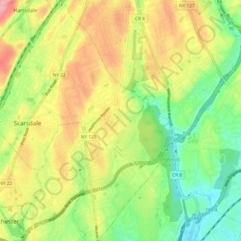
Name: Village of Scarsdale topographic map, elevation, terrain.
Average elevation: 249 ft
Minimum elevation: 95 ft
Maximum elevation: 440 ft
Westchester County trails, hiking, mountain biking, running and outdoor activities
Other topographic maps
Click on a map to view its topography, its elevation and its terrain.
Ward Pound Ridge Reservation
United States > New York > Westchester County > Town of Pound Ridge
Average elevation: 538 ft
Riveredge Trailer Park
United States > New York > Westchester County > Town of Cortlandt > Verplanck
Average elevation: 46 ft
Isle of San Souci
United States > New York > Westchester County > City of New Rochelle
Average elevation: 23 ft
Wykagyl Park
United States > New York > Westchester County > City of New Rochelle
Average elevation: 135 ft
Lake Waccabuc
United States > New York > Westchester County > Town of Lewisboro > Waccabuc
Average elevation: 568 ft
Sherman Park
United States > New York > Westchester County > Town of Mount Pleasant > Thornwood
Average elevation: 436 ft
Mariandale
United States > New York > Westchester County > Village of Ossining
Average elevation: 174 ft
Pleasantside
United States > New York > Westchester County > Town of Cortlandt
Average elevation: 354 ft
Salem Center
United States > New York > Westchester County > Town of North Salem
Average elevation: 482 ft
Bonnie Crest
United States > New York > Westchester County > City of New Rochelle
Average elevation: 190 ft
Vernon Park
United States > New York > Westchester County > City of Mount Vernon
Average elevation: 102 ft
Lake Mohansic
United States > New York > Westchester County > Town of Yorktown
Average elevation: 522 ft
West Harrison Village Green
United States > New York > Westchester County > Town/Village of Harrison > East White Plains
Average elevation: 259 ft
Colonial Heights
United States > New York > Westchester County > City of Yonkers
Average elevation: 197 ft
Sedge Island
United States > New York > Westchester County > City of New Rochelle
Average elevation: 154 ft
Crestwood Gardens
United States > New York > Westchester County > City of Yonkers
Average elevation: 213 ft
Jefferson Valley
United States > New York > Westchester County > Jefferson Valley-Yorktown
Average elevation: 584 ft
Gunther Park
United States > New York > Westchester County > City of Yonkers
Average elevation: 184 ft
Chauncey
United States > New York > Westchester County > Village of Dobbs Ferry
Average elevation: 249 ft
Fenmore Park
United States > New York > Westchester County > Town/Village of Harrison
Average elevation: 125 ft
Shore Acres
United States > New York > Westchester County > Village of Mamaroneck
Average elevation: 36 ft
Bronxville Heights
United States > New York > Westchester County > City of Yonkers
Average elevation: 207 ft
Mount Hope
United States > New York > Westchester County > Village of Hastings-on-Hudson
Average elevation: 197 ft
Ridgeway
United States > New York > Westchester County > City of White Plains
Average elevation: 249 ft
Wykagyl
United States > New York > Westchester County > City of New Rochelle
Average elevation: 151 ft
New York, Westchester and Boston Railway
United States > New York > Westchester County > Village of Pelham > North Pelham
Average elevation: 92 ft
Sleepy Hollow Manor
United States > New York > Westchester County > Village of Sleepy Hollow > Sleepy Hollow Manor
Average elevation: 135 ft
Spring Valley
United States > New York > Westchester County > Town of Ossining > Ossining > Spring Valley
Average elevation: 377 ft
Whitehall Corners
United States > New York > Westchester County > Town of Somers
Average elevation: 318 ft
Sarles Corners
United States > New York > Westchester County > Town of Pound Ridge
Average elevation: 463 ft
Secor Gardens
United States > New York > Westchester County > Village of Scarsdale
Average elevation: 230 ft