
Make a donation
Gear up for your next adventure:
As an Amazon Associate, this site earns from qualifying purchases at no extra cost to you.
Baguio topographic map
Click on the map to display elevation.
Make a donation
Gear up for your next adventure:
As an Amazon Associate, this site earns from qualifying purchases at no extra cost to you.
Baguio
In 1903, Filipinos, Japanese and Chinese workers were hired to build Kennon Road, the first road directly connecting Baguio with the lowlands of La Union and Pangasinan. Before this, the only road to Benguet was Naguilian Road, and it was largely a horse trail at higher elevations. Camp John Hay was established on October 25, 1903 after President Theodore Roosevelt signed an executive order setting aside land in Benguet for a military reservation for the United States Army. It was named after Roosevelt's Secretary of State, John Milton Hay.
Make a donation
Gear up for your next adventure:
As an Amazon Associate, this site earns from qualifying purchases at no extra cost to you.
About this map
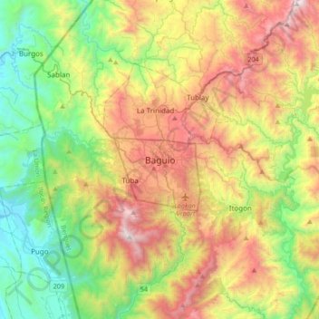
Name: Baguio topographic map, elevation, terrain.
Location: Baguio, Cordillera Administrative Region, 2600, Philippines (16.25200 120.43337 16.57200 120.75337)
Average elevation: 2,890 ft
Minimum elevation: 79 ft
Maximum elevation: 7,303 ft
Make a donation
Gear up for your next adventure:
As an Amazon Associate, this site earns from qualifying purchases at no extra cost to you.
Other topographic maps
Click on a map to view its topography, its elevation and its terrain.
Ilocos Region
The southern parts of the region were severely hit by the 1990 Luzon earthquake. Five municipalities in La Union were affected: Agoo, Aringay, Caba, Santo Tomas, and Tubao with a combined population of 132,208. Many buildings, including the Agoo Municipal hall, the Museo de Iloko, the parish church of Aringay,…
Average elevation: 719 ft
Make a donation
Gear up for your next adventure:
As an Amazon Associate, this site earns from qualifying purchases at no extra cost to you.
Mataasnakahoy
Mataasnakahoy has 16 barangays and its total land area is 22.10 square kilometers (8.53 sq mi). It is bounded by Balete and Lipa City with Taal Lake on its western edge. The town is known for its cool climate due to its high elevation of 379 meters (1,243 ft).
Average elevation: 728 ft
Make a donation
Gear up for your next adventure:
As an Amazon Associate, this site earns from qualifying purchases at no extra cost to you.
Magsaysay
Philippines > Occidental Mindoro
Magsaysay, one of the eleven municipalities in the Occidental Mindoro, lies on the southernmost part of Mindoro Island, and is adjacent to the municipality of San Jose on the north; on the east separated by chain of valleys and mountains in the municipality of Bulalacao, Oriental Mindoro; on the south, by…
Average elevation: 203 ft
Caballo Island
Philippines > Cavite > Cavite City
Caballo Island (which means "Horse Island" in Spanish) is a bluff, rocky island located at the entrance to Manila Bay in the Philippines. It is about 1.2 km (0.75 mi) long with the highest elevation at 381 feet high. Caballo, along with the larger Corregidor (2 km to the north), divides the entrance to the bay…
Average elevation: 0 ft
Make a donation
Gear up for your next adventure:
As an Amazon Associate, this site earns from qualifying purchases at no extra cost to you.
Pampanga River
Its main tributaries are Peñaranda and the Coronel-Santor rivers on the eastern side of the basin and the Rio Chico River from the northwest side. The Angat River joins the Pampanga River at Calumpit, Bulacan via the Bagbag River. Mount Arayat (elevation: 1,026 metres (3,366 ft)) stands in the middle of the…
Average elevation: 623 ft
Make a donation
Gear up for your next adventure:
As an Amazon Associate, this site earns from qualifying purchases at no extra cost to you.
Make a donation
Gear up for your next adventure:
As an Amazon Associate, this site earns from qualifying purchases at no extra cost to you.
Isabela
The province is divided into three physiographic areas. The eastern area, straddled by the Sierra Madre mountain range, is rugged and thickly forested. A substantial portion is uncharted. These unexplored hinterlands are home to a rich variety of flora and fauna, and some are under government reservations. It…
Average elevation: 745 ft
Make a donation
Gear up for your next adventure:
As an Amazon Associate, this site earns from qualifying purchases at no extra cost to you.
Make a donation
Gear up for your next adventure:
As an Amazon Associate, this site earns from qualifying purchases at no extra cost to you.
Make a donation
Gear up for your next adventure:
As an Amazon Associate, this site earns from qualifying purchases at no extra cost to you.
Make a donation
Gear up for your next adventure:
As an Amazon Associate, this site earns from qualifying purchases at no extra cost to you.
Make a donation
Gear up for your next adventure:
As an Amazon Associate, this site earns from qualifying purchases at no extra cost to you.
Pulilan
The municipality is generally of flat topography. Eleven (11) of its barangays are bounded by the Angat River. The rest are flat irrigated rice lands. Soil types vary from sandy loam to clay loam which makes the municipality suitable to a wide range of agricultural products.
Average elevation: 33 ft
Make a donation
Gear up for your next adventure:
As an Amazon Associate, this site earns from qualifying purchases at no extra cost to you.
Make a donation
Gear up for your next adventure:
As an Amazon Associate, this site earns from qualifying purchases at no extra cost to you.
Make a donation
Gear up for your next adventure:
As an Amazon Associate, this site earns from qualifying purchases at no extra cost to you.
Make a donation
Gear up for your next adventure:
As an Amazon Associate, this site earns from qualifying purchases at no extra cost to you.
Make a donation
Gear up for your next adventure:
As an Amazon Associate, this site earns from qualifying purchases at no extra cost to you.
Make a donation
Gear up for your next adventure:
As an Amazon Associate, this site earns from qualifying purchases at no extra cost to you.
Isabela
The elevation of Isabela to 4th-class city status gave the local government a much-needed boost, efficiently delivered under the Biel administration, revitalized Isabela City, making it an engine of growth for Basilan province even as the hinterlands was wracked by incessant firefights and gun-battles between…
Average elevation: 305 ft
Make a donation
Gear up for your next adventure:
As an Amazon Associate, this site earns from qualifying purchases at no extra cost to you.
Make a donation
Gear up for your next adventure:
As an Amazon Associate, this site earns from qualifying purchases at no extra cost to you.
Make a donation
Gear up for your next adventure:
As an Amazon Associate, this site earns from qualifying purchases at no extra cost to you.
Make a donation
Gear up for your next adventure:
As an Amazon Associate, this site earns from qualifying purchases at no extra cost to you.
Make a donation
Gear up for your next adventure:
As an Amazon Associate, this site earns from qualifying purchases at no extra cost to you.
Make a donation
Gear up for your next adventure:
As an Amazon Associate, this site earns from qualifying purchases at no extra cost to you.
Make a donation
Gear up for your next adventure:
As an Amazon Associate, this site earns from qualifying purchases at no extra cost to you.
Make a donation
Gear up for your next adventure:
As an Amazon Associate, this site earns from qualifying purchases at no extra cost to you.
Make a donation
Gear up for your next adventure:
As an Amazon Associate, this site earns from qualifying purchases at no extra cost to you.