
London topographic map
Interactive map
Click on the map to display elevation.
About this map
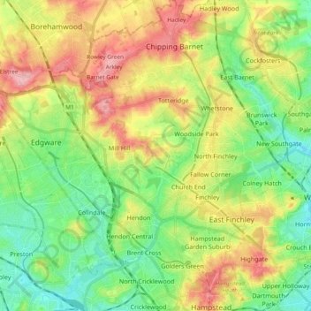
Name: London topographic map, elevation, terrain.
Average elevation: 253 ft
Minimum elevation: 92 ft
Maximum elevation: 489 ft
Other topographic maps
Click on a map to view its topography, its elevation and its terrain.
Gorilla Circus Regents Park Flying Trapeze School
United Kingdom > England > London > Camden Town
Average elevation: 135 ft
Romford
United Kingdom > England > London
The town centre is about 50 feet (15 m) above sea level on a gravel terrace rising from the River Thames. The north of the town has developed on London Clay and is situated as much as 150 ft (46 m) above sea level. A continuous gentle rise in the eastern suburbs towards Gidea Park and Harold Wood peaks around…
Average elevation: 95 ft