
Fort Erie topographic map
Interactive map
Click on the map to display elevation.
About this map
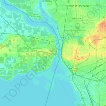
Name: Fort Erie topographic map, elevation, terrain.
Location: Fort Erie, Niagara Region, Golden Horseshoe, Ontario, Canada (42.83200 -79.12255 42.98529 -78.90595)
Average elevation: 597 ft
Minimum elevation: 561 ft
Maximum elevation: 732 ft
Other topographic maps
Click on a map to view its topography, its elevation and its terrain.
Queenston Heights Park
Canada > Ontario > Niagara Region > Niagara-on-the-Lake > Queenston
Average elevation: 456 ft