
Scottsdale topographic map
Interactive map
Click on the map to display elevation.
Scottsdale
Scottsdale features a diverse topography shaped by its location within the Sonoran Desert and the foothills of the McDowell Mountains. The city sits at an average elevation of about 1,827 feet (558 meters), with a range that spans from approximately 1,052 feet (321 meters) at its lowest points to 4,819 feet (1,469 meters) at its highest, including Butte Peak. The landscape is characterized by rugged hills, sandy washes, and gently rolling valleys, interspersed with various desert flora and striking rock formations. The surrounding area is marked by scenic hiking trails and recreational parks, offering residents and visitors alike ample opportunities to explore the unique desert environment. This varied terrain not only contributes to the region's natural beauty but also plays a significant role in the local ecosystem and recreational activities.
About this map
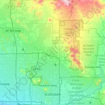
Name: Scottsdale topographic map, elevation, terrain.
Location: Scottsdale, Maricopa County, Arizona, United States (33.44763 -111.96093 33.90053 -111.75607)
Average elevation: 1,814 ft
Minimum elevation: 1,050 ft
Maximum elevation: 4,816 ft
Maricopa County trails, hiking, mountain biking, running and outdoor activities
Other topographic maps
Click on a map to view its topography, its elevation and its terrain.
Scottsdale
United States > Arizona > Maricopa County > Scottsdale
The city is in the Salt River Valley, or the "Valley of the Sun," in the northern reaches of the Sonoran Desert. Scottsdale, 31 mi (50 km) long and 11.4 mi (18.3 km) wide at its widest point, shares boundaries with many other municipalities and entities. On the west, Scottsdale is bordered by Phoenix, Paradise…
Average elevation: 1,358 ft
Tempe
United States > Arizona > Maricopa County > Tempe
Tempe is generally flat, except for Hayden Butte (generally known as A-Mountain for Arizona State University's "A" logo located on its south face), located next to Sun Devil Stadium, Twin Buttes and Bell Butte on the western edge of Tempe, and Papago Park northwest of Tempe, inside Phoenix. Elevation ranges…
Average elevation: 1,266 ft
Phoenix
United States > Arizona > Maricopa County > Phoenix
Phoenix is in the south-central portion of Arizona; about halfway between Tucson to the southeast and Flagstaff to the north, in the southwestern United States. By car, the city is approximately 150 miles (240 kilometers) north of the US–Mexico border at Sonoyta and 180 mi (290 km) north of the border at…
Average elevation: 1,207 ft
Komatke
United States > Arizona > Maricopa County > Komatke
Saint John the Baptist Parish Laveen, the Saint Johns Mission, is in Komatke. The name is taken from the mission school founded by the Franciscans in 1894. It has an estimated elevation of 1,030 feet (310 m) above sea level.
Average elevation: 1,099 ft
Camelback Mountain
United States > Arizona > Maricopa County > Phoenix
Efforts to protect Camelback Mountain as a natural preserve began in the early 1910s. However, by the 1960s, nearly all of the area had been sold to private interests. Federal and state authorities attempted to stop development above the one thousand and six hundred feet level. They failed to halt development…
Average elevation: 1,516 ft
Saddle
United States > Arizona > Maricopa County > Saddle
Saddle is a populated place situated in Maricopa County, Arizona, United States. It has an estimated elevation of 722 feet (220 m) above sea level. It is located on the Union Pacific Railroad's Phoenix Subdivision.
Average elevation: 722 ft