
Bandraboua topographic map
Interactive map
Click on the map to display elevation.
About this map
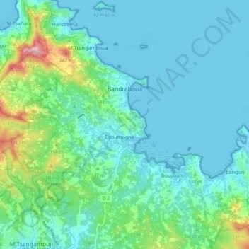
Name: Bandraboua topographic map, elevation, terrain.
Location: Bandraboua, Mayotte, 97650, France (-12.76235 45.08867 -12.67279 45.15887)
Average elevation: 256 ft
Minimum elevation: -13 ft
Maximum elevation: 1,453 ft
Other topographic maps
Click on a map to view its topography, its elevation and its terrain.
Bambo-Ouest
Bambo-Ouest, Bouéni, Mayotte, 97620, France
Average elevation: 98 ft
Dzoumogné
France > Mayotte > Bandraboua
Dzoumogné, Bandraboua, Mayotte, 97650, France
Average elevation: 184 ft
Tsoundzou 1
Tsoundzou 1, Mamoudzou, Mayotte, 97605, France
Average elevation: 171 ft
Chembenyoumba
France > Mayotte > M'Tsangamouji
Chembenyoumba, M'Tsangamouji, Mayotte, 97650, France
Average elevation: 121 ft
Petite-Terre
Petite-Terre, Dzaoudzi, Mayotte, 97610, France
Average elevation: 33 ft
Plage d'Iloni
Plage d'Iloni, Dembéni, Mayotte, 97660, France
Average elevation: 108 ft
Chissioua Bandrélé
Chissioua Bandrélé, Bandrélé, Mayotte, 97620, France
Average elevation: 3 ft
Parc de la Pointe Mahabou
Parc de la Pointe Mahabou, Doujani, Mamoudzou, Mayotte, 97600, France
Average elevation: 20 ft
Chissioua Mtsamboro
Chissioua Mtsamboro, Mtsamboro, Mayotte, 97630, France
Average elevation: 75 ft
Îlot Mbouzi
Îlot Mbouzi, Mamoudzou, Mayotte, 97600, France
Average elevation: 16 ft