
Harrisonburg topographic map
Interactive map
Click on the map to display elevation.
About this map
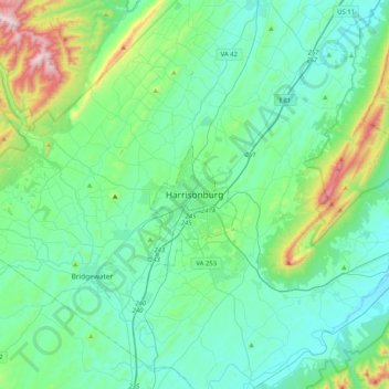
Name: Harrisonburg topographic map, elevation, terrain.
Location: Harrisonburg, Virginia, 22807, United States (38.28933 -79.02888 38.60933 -78.70888)
Average elevation: 1,463 ft
Minimum elevation: 965 ft
Maximum elevation: 3,694 ft
Virginia trails, hiking, mountain biking, running and outdoor activities
Other topographic maps
Click on a map to view its topography, its elevation and its terrain.
Smith Mountain Lake
United States > Virginia > Franklin County > North Shore
Average elevation: 902 ft
Carroll County
The first European settlers arrived in the region in the mid 18th century. These were primarily Scotch-Irish pioneers, who were used to high mountain altitudes. However, early settlement was slow, mostly due to the poor agricultural soil of the area. As a result, lead mining was one of the first economic…
Average elevation: 2,326 ft
C.F. Phelps Wildlife Management Area
United States > Virginia > Fauquier County
Average elevation: 312 ft
Painter
United States > Virginia > Accomack County
It lies at an elevation of 36 feet.
Average elevation: 33 ft
Kiptopeke State Park
United States > Virginia > Northampton County > Kiptopeke
Average elevation: 20 ft
Robious Landing Park
United States > Virginia > Chesterfield County > Midlothian
Average elevation: 180 ft
Barboursville Community Park
United States > Virginia > Orange County > Barboursville
Average elevation: 518 ft
Breaks Interstate Park
United States > Virginia > Buchanan County > Conaway
Average elevation: 1,565 ft
Claytor Lake State Park
United States > Virginia > Pulaski County > Dublin
Average elevation: 1,893 ft
George Washington's Mount Vernon
United States > Virginia > Fairfax County > Mount Vernon
Average elevation: 46 ft
Cape Charles
United States > Virginia > Northampton County
Cape Charles lies on a peninsula and is surrounded by water on three sides. The town is situated directly on the Chesapeake Bay, bordered by King's Creek to the north and Old Plantation Creek to the south. The land in town is low lying and relatively flat, with the highest point of elevation at 15 feet, and a…
Average elevation: 7 ft
McLean
United States > Virginia > Fairfax County
McLean is located at 38°56′03″N 77°10′39″W / 38.93417°N 77.17750°W / 38.93417; -77.17750 (38.9342776, −77.1774801) at an elevation of 285 feet (87 m). Located on the Capital Beltway (Interstate 495) in Northern Virginia, central McLean is 8 miles (13 km) northwest of downtown Washington,…
Average elevation: 292 ft