
Flintstone topographic map
Interactive map
Click on the map to display elevation.
About this map
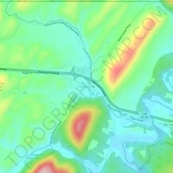
Name: Flintstone topographic map, elevation, terrain.
Location: Flintstone, Allegany County, Maryland, 21530, United States (39.68314 -78.58779 39.72314 -78.54779)
Average elevation: 965 ft
Minimum elevation: 725 ft
Maximum elevation: 1,578 ft
Allegany County trails, hiking, mountain biking, running and outdoor activities
Other topographic maps
Click on a map to view its topography, its elevation and its terrain.
Frostburg
United States > Maryland > Allegany County
Due to its average elevation of 2,000 feet (610 m) above sea level and location near the Allegheny Front, Frostburg has a colder, wetter climate than much of the rest of the state, and falls in USDA hardiness zone 6b. Under the Köppen climate classification, it has a humid continental climate (Dfb), with…
Average elevation: 2,034 ft
Rawlings
United States > Maryland > Allegany County > Rawlings > Rawlings Heights
Average elevation: 860 ft
Shaft
United States > Maryland > Allegany County > Borden Shaft > Braddock Estates
Shaft is a census-designated place (CDP) corresponding to the unincorporated community of Borden Shaft in Allegany County, Maryland, United States. As of the 2010 census, the CDP had a population of 235. It is located south of Frostburg, in the Georges Creek Valley. It lies at an elevation of 1,795 feet (547…
Average elevation: 1,929 ft
Lavale Community Park
United States > Maryland > Allegany County > Allegany Grove
Average elevation: 1,161 ft
County Fairgrounds
United States > Maryland > Allegany County > Potomac Park > Cedar Cliff
Average elevation: 899 ft