
Stewart County topographic map
Interactive map
Click on the map to display elevation.
About this map
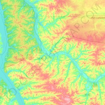
Name: Stewart County topographic map, elevation, terrain.
Location: Stewart County, Middle Tennessee, Tennessee, United States (36.32872 -88.07053 36.67812 -87.59235)
Average elevation: 515 ft
Minimum elevation: 341 ft
Maximum elevation: 784 ft
Tennessee trails, hiking, mountain biking, running and outdoor activities
Other topographic maps
Click on a map to view its topography, its elevation and its terrain.
Elizabethton
United States > Tennessee > Carter County > Elizabethton > Elizabethton
The elevation at Elizabethton Municipal Airport is 1,593 feet (486 m) ASL (the highest point of elevation in Carter County is at Roan Mountain with an elevation of 6,285 feet (1,916 m) ASL), and the airport is located on the eastern side of the city along State Highway 91 Stoney Creek Exit. Elizabethton is…
Average elevation: 1,729 ft
Morrison Springs
United States > Tennessee > Hamilton County > Chattanooga > Red Bank
Average elevation: 1,073 ft
Glenwood
United States > Tennessee > Hamilton County > Chattanooga > Ridgeside
Average elevation: 751 ft
Tennesse Riverwalk
United States > Tennessee > Hamilton County > Chattanooga
Average elevation: 679 ft
Eastdale
United States > Tennessee > Hamilton County > Chattanooga > Ridgeside
Average elevation: 778 ft
Whites Creek
United States > Tennessee > Davidson County > Nashville-Davidson
Average elevation: 591 ft
Bays Mountain
United States > Tennessee > Hawkins County
The southern segment of Bays Mountain is relatively low in elevation (up to about 1,300 feet (396.2 m)). In some places it essentially merges with the surrounding plains, especially where it is bisected by the French Broad River and the Nolichucky River. The northern segment of Bays Mountain reaches higher…
Average elevation: 1,375 ft
Douglas Dam
United States > Tennessee > Sevier County
The Douglas Project required the construction of ten smaller, earthen saddle dams to fill in gaps along the adjacent ridgeline and permit a higher water elevation than would otherwise be possible. Most of these saddle dams are located in the hills southeast of the main dam. One protects downtown Dandridge,…
Average elevation: 1,024 ft
Colewood Acres
United States > Tennessee > Davidson County > Nashville-Davidson
Average elevation: 604 ft
Alpine Heights
United States > Tennessee > Hamilton County > Chattanooga > Red Bank
Average elevation: 817 ft
Spring Valley
United States > Tennessee > Hamilton County > Chattanooga > Red Bank
Average elevation: 1,047 ft
Staffordtown
United States > Tennessee > Polk County > Copperhill
Staffordtown is situated in the scenic Appalachian region, characterized by its rugged terrain and lush forests. The area is marked by steep hills and rolling valleys that define the landscape, with elevations ranging from around 1,500 to 3,000 feet above sea level. The surrounding mountains, part of the…
Average elevation: 1,568 ft
Sevier Park
United States > Tennessee > Davidson County > Nashville-Davidson
Average elevation: 568 ft
Delray Park Estates
United States > Tennessee > Sumner County > Hendersonville
Average elevation: 476 ft
Little Creek
United States > Tennessee > Davidson County > Nashville-Davidson
Average elevation: 636 ft