
Mount Savage topographic map
Interactive map
Click on the map to display elevation.
Mount Savage
A small blue-collar community, Mount Savage lies at the base of Big Savage Mountain in the Allegheny Mountains, between the cities of Frostburg and Cumberland. It began as a small farming settlement in the mid-19th century, but it was not until 1844 that the region was put on the nation's map with the pressing of the first iron rail in the United States. After this claim to fame, Mount Savage became the fifth largest city in Maryland. Named as the headquarters for the Mount Savage Railroad and later the Cumberland and Pennsylvania Railroad (C&P), the area was deemed an industrial center. In addition to the rail businesses, Mount Savage attracted a foundry, two brick refractories, and several local merchants. In this company town, the industries shaped the economy and topography of Mount Savage, building housing for workers and donating land for schools, churches, and other public buildings. It was a cultural melting pot attracting English businessmen and Irish, Scottish, Welsh, Italian, and German workers. With this diverse mix of cultures, the identity of Mount Savage was molded into a close-knit community. Despite the loss of the industries to the region, Mount Savage continues to celebrate its hard-working traditions. The Mount Savage Historic District was listed on the National Register of Historic Places in 1983.
About this map
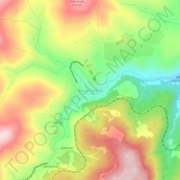
Name: Mount Savage topographic map, elevation, terrain.
Average elevation: 1,562 ft
Minimum elevation: 1,037 ft
Maximum elevation: 2,096 ft
Allegany County trails, hiking, mountain biking, running and outdoor activities
Other topographic maps
Click on a map to view its topography, its elevation and its terrain.
Frostburg
United States > Maryland > Allegany County
Due to its average elevation of 2,000 feet (610 m) above sea level and location near the Allegheny Front, Frostburg has a colder, wetter climate than much of the rest of the state, and falls in USDA hardiness zone 6b. Under the Köppen climate classification, it has a humid continental climate (Dfb), with…
Average elevation: 2,034 ft
Rawlings
United States > Maryland > Allegany County > Rawlings > Rawlings Heights
Average elevation: 860 ft
Shaft
United States > Maryland > Allegany County > Borden Shaft > Braddock Estates
Shaft is a census-designated place (CDP) corresponding to the unincorporated community of Borden Shaft in Allegany County, Maryland, United States. As of the 2010 census, the CDP had a population of 235. It is located south of Frostburg, in the Georges Creek Valley. It lies at an elevation of 1,795 feet (547…
Average elevation: 1,929 ft
Lavale Community Park
United States > Maryland > Allegany County > Allegany Grove
Average elevation: 1,161 ft
County Fairgrounds
United States > Maryland > Allegany County > Potomac Park > Cedar Cliff
Average elevation: 899 ft