
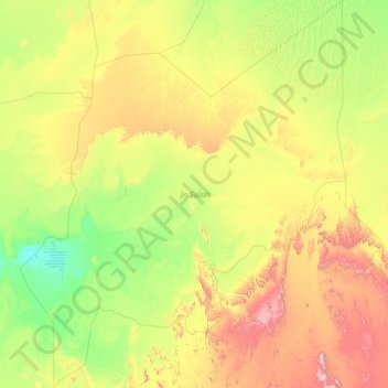
In Salah topographic map
Interactive map
Click on the map to display elevation.
About this map
Name: In Salah topographic map, elevation, terrain.
Location: In Salah, Algeria (24.63672 0.93302 29.75830 5.77701)
Average elevation: 1,588 ft
Minimum elevation: 394 ft
Maximum elevation: 7,123 ft
Other topographic maps
Click on a map to view its topography, its elevation and its terrain.
El Euch Oufalkou
Algeria > Bordj Bou Arreridj > El Hamadia District > El Euch
Average elevation: 2,608 ft
Clos de car
Algeria > Algiers > Dar el-Beida District > Bordj El Bahri > Bordj el Bahri Faizi
Average elevation: 62 ft
Hammam Bouakaz
Algeria > Mila > Ain Beida Harriche District > El Ayadi Barbes
Average elevation: 1,801 ft
Haouche Delbi
Algeria > Bouira > Sour El Ghozlane District > Sour El Ghozlane
Average elevation: 2,904 ft
In Amguel
Algeria > Tamanrasset > In Amguel
In Amguel lies at an elevation of 981 metres (3,219 ft) on the southern bank of a wadi that cuts through a plateau lying to the northwest of the Hoggar Mountains. The numerous wadis in the area support some vegetation, but beyond them the land is barren and rocky.
Average elevation: 3,255 ft
El Harrouch
Algeria > Skikda > El Harrouch District > El Harrouch > El Harrouch
Average elevation: 571 ft
Cité diar el afia bourouba
Algeria > Algiers > El Harrach District > Cité diar el afia bourouba
Average elevation: 82 ft
Azaghar (chamlal)
Algeria > Tizi Ouzou > Tizi Ouzou District > Tizi Ouzou > Ioualayen
Average elevation: 338 ft