
Make a donation
Gear up for your next adventure:
As an Amazon Associate, this site earns from qualifying purchases at no extra cost to you.
City of Peekskill topographic map
Click on the map to display elevation.
Gear up for your next adventure:
As an Amazon Associate, this site earns from qualifying purchases at no extra cost to you.
About this map
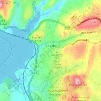
Name: City of Peekskill topographic map, elevation, terrain.
Average elevation: 220 ft
Minimum elevation: 0 ft
Maximum elevation: 656 ft
Westchester County trails, hiking, mountain biking, running and outdoor activities
Make a donation
Gear up for your next adventure:
As an Amazon Associate, this site earns from qualifying purchases at no extra cost to you.
Other topographic maps
Click on a map to view its topography, its elevation and its terrain.
Hawthorne
United States > New York > Westchester County > Town of Mount Pleasant
Average elevation: 390 ft
Cedar Knolls
United States > New York > Westchester County > City of Yonkers
Average elevation: 187 ft
Whitehall Corners
United States > New York > Westchester County > Town of Somers
Average elevation: 318 ft
Make a donation
Gear up for your next adventure:
As an Amazon Associate, this site earns from qualifying purchases at no extra cost to you.
Beechmont
United States > New York > Westchester County > City of New Rochelle
Average elevation: 102 ft
Whitehall Corners
United States > New York > Westchester County > Town of Somers
Average elevation: 318 ft
Sunset Ridge
United States > New York > Westchester County > Town/Village of Harrison
Average elevation: 89 ft
Heath Ridge
United States > New York > Westchester County > Village of Scarsdale
Average elevation: 217 ft
Make a donation
Gear up for your next adventure:
As an Amazon Associate, this site earns from qualifying purchases at no extra cost to you.
Buckhout Corners
United States > New York > Westchester County > Village of Briarcliff Manor
Average elevation: 367 ft
Mohegan Heights
United States > New York > Westchester County > City of Yonkers
Average elevation: 190 ft
Make a donation
Gear up for your next adventure:
As an Amazon Associate, this site earns from qualifying purchases at no extra cost to you.
Lake Katonah
United States > New York > Westchester County > Town of Lewisboro
Average elevation: 417 ft
South Ridge
United States > New York > Westchester County > Village of Rye Brook
Average elevation: 121 ft
Turkey Mountain
United States > New York > Westchester County > Town of Yorktown
Average elevation: 466 ft
Make a donation
Gear up for your next adventure:
As an Amazon Associate, this site earns from qualifying purchases at no extra cost to you.
Murdock Woods
United States > New York > Westchester County > Town of Mamaroneck
Average elevation: 151 ft
Sleepy Hollow Manor
United States > New York > Westchester County > Village of Sleepy Hollow
Average elevation: 135 ft
Furnace Woods
United States > New York > Westchester County > Town of Cortlandt
Average elevation: 381 ft
Pleasantside
United States > New York > Westchester County > Town of Cortlandt
Average elevation: 354 ft
Make a donation
Gear up for your next adventure:
As an Amazon Associate, this site earns from qualifying purchases at no extra cost to you.
Salem Center
United States > New York > Westchester County > Town of North Salem
Average elevation: 482 ft
Isle of San Souci
United States > New York > Westchester County > City of New Rochelle
Average elevation: 23 ft
South Salem
United States > New York > Westchester County > Town of Lewisboro
Average elevation: 571 ft
Getty Square
United States > New York > Westchester County > City of Yonkers > Ludlow
Average elevation: 102 ft
Van Cortlandtville
United States > New York > Westchester County > Town of Cortlandt
Average elevation: 262 ft
Make a donation
Gear up for your next adventure:
As an Amazon Associate, this site earns from qualifying purchases at no extra cost to you.
Wykagyl Park
United States > New York > Westchester County > City of New Rochelle
Average elevation: 135 ft
Sun Haven
United States > New York > Westchester County > City of New Rochelle
Average elevation: 66 ft
Murray Hill
United States > New York > Westchester County > Village of Scarsdale
Average elevation: 259 ft
West Mount Vernon
United States > New York > Westchester County > City of Mount Vernon
Average elevation: 161 ft
Purdys Grove
United States > New York > Westchester County > Village of Port Chester
Average elevation: 46 ft
Make a donation
Gear up for your next adventure:
As an Amazon Associate, this site earns from qualifying purchases at no extra cost to you.
Van Cortlandtville
United States > New York > Westchester County > Town of Cortlandt
Average elevation: 262 ft
Bedford Hills
United States > New York > Westchester County > Town of Bedford > Bedford Hills
Average elevation: 374 ft
Vista
United States > New York > Westchester County > Town of Lewisboro > Vista
Average elevation: 505 ft
Park Hill
United States > New York > Westchester County > City of Yonkers > Park Hill
Average elevation: 141 ft
Make a donation
Gear up for your next adventure:
As an Amazon Associate, this site earns from qualifying purchases at no extra cost to you.