
Make a donation
Gear up for your next adventure:
As an Amazon Associate, this site earns from qualifying purchases at no extra cost to you.
Birmingham topographic map
Click on the map to display elevation.
Make a donation
Gear up for your next adventure:
As an Amazon Associate, this site earns from qualifying purchases at no extra cost to you.
Birmingham
Birmingham is a snowy city relative to other large UK conurbations, due to its inland location and comparatively high elevation. Between 1961 and 1990 Birmingham Airport averaged 13.0 days of snow lying annually, compared to 5.33 at London Heathrow. Snow showers often pass through the city via the Cheshire gap on north westerly airstreams, but can also come off the North Sea from north easterly airstreams.
Make a donation
Gear up for your next adventure:
As an Amazon Associate, this site earns from qualifying purchases at no extra cost to you.
About this map
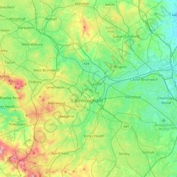
Name: Birmingham topographic map, elevation, terrain.
Location: Birmingham, West Midlands, England, United Kingdom (52.38105 -2.03365 52.60871 -1.72884)
Average elevation: 453 ft
Minimum elevation: 217 ft
Maximum elevation: 1,024 ft
Make a donation
Gear up for your next adventure:
As an Amazon Associate, this site earns from qualifying purchases at no extra cost to you.
Other topographic maps
Click on a map to view its topography, its elevation and its terrain.
Cambridge
United Kingdom > England > Cambridge
The city, like most of the UK, has a maritime climate highly influenced by the Gulf Stream. Located in the driest region of Britain, Cambridge's rainfall averages around 570 mm (22.44 in) per year, around half the national average, with some years occasionally falling into the semi-arid (under 500 mm (19.69…
Average elevation: 59 ft
Make a donation
Gear up for your next adventure:
As an Amazon Associate, this site earns from qualifying purchases at no extra cost to you.
Make a donation
Gear up for your next adventure:
As an Amazon Associate, this site earns from qualifying purchases at no extra cost to you.
Leeds
Lying in the eastern foothills of the Pennines, there is a significant variation in elevation within the city's built-up area. The district ranges from 1,115 feet (340 m) in the far west on the slopes of Ilkley Moor to about 33 feet (10 m) where the rivers Aire and Wharfe cross the eastern boundary. Land rises…
Average elevation: 308 ft
Chard
United Kingdom > England > Somerset
Chard is a town and a civil parish in the English county of Somerset. It lies on the A30 road near the Devon and Dorset borders, 15 miles (24 km) south west of Yeovil. The parish has a population of approximately 13,000 and, at an elevation of 121 metres (397 ft), Chard is the southernmost and one of the…
Average elevation: 443 ft
Make a donation
Gear up for your next adventure:
As an Amazon Associate, this site earns from qualifying purchases at no extra cost to you.
Make a donation
Gear up for your next adventure:
As an Amazon Associate, this site earns from qualifying purchases at no extra cost to you.
St Albans
United Kingdom > England > Hertfordshire > St Albans
St Albans was an ancient borough created following the dissolution of the monastery in 1539. It consisted of the ancient parish of St Albans (also known as the Abbey parish) and parts of St Michael and St Peter. The municipal corporation was reformed by the Municipal Corporations Act 1835 and the boundary was…
Average elevation: 328 ft
Make a donation
Gear up for your next adventure:
As an Amazon Associate, this site earns from qualifying purchases at no extra cost to you.
Make a donation
Gear up for your next adventure:
As an Amazon Associate, this site earns from qualifying purchases at no extra cost to you.
Swindon
United Kingdom > England > Swindon
Swindon has an oceanic climate (Cfb in the Köppen climate classification), like the vast majority of the British Isles, with cool winters and warm summers. The nearest official weather station is RAF Lyneham, about 10 miles (16 km) west southwest of Swindon town centre. The weather station's elevation is 145…
Average elevation: 354 ft
Newby Bridge
United Kingdom > England > Westmorland and Furness > Finsthwaite
Average elevation: 358 ft
Make a donation
Gear up for your next adventure:
As an Amazon Associate, this site earns from qualifying purchases at no extra cost to you.
Basingstoke
United Kingdom > England > Hampshire > Basingstoke and Deane
Situated in a valley through the Hampshire Downs at an average elevation of 88 metres (289 ft) Basingstoke is a major interchange between Reading, Newbury, Andover, Winchester, and Alton, and lies on the natural trade route between the southwest of England and London. The area had been something of an…
Average elevation: 351 ft
Make a donation
Gear up for your next adventure:
As an Amazon Associate, this site earns from qualifying purchases at no extra cost to you.
City of London
United Kingdom > England > City of London > City of London
The elevation of the City ranges from sea level at the Thames to 21.6 metres (71 ft) at the junction of High Holborn and Chancery Lane. Two small but notable hills are within the historic core, Ludgate Hill to the west and Cornhill to the east. Between them ran the Walbrook, one of the many "lost" rivers or…
Average elevation: 138 ft
Make a donation
Gear up for your next adventure:
As an Amazon Associate, this site earns from qualifying purchases at no extra cost to you.
Castle Donington
United Kingdom > England > North West Leicestershire > Castle Donington
Average elevation: 203 ft
Make a donation
Gear up for your next adventure:
As an Amazon Associate, this site earns from qualifying purchases at no extra cost to you.
South Shields
United Kingdom > England > Tyne and Wear > South Tyneside
The current town was founded in 1245 and developed as a fishing port. The name South Shields developed from the 'Schele' or 'Shield', which was a small dwelling used by fishermen. Another industry that was introduced, was that of salt-panning, later expanded upon in the 15th century, polluting the air and…
Average elevation: 75 ft
Make a donation
Gear up for your next adventure:
As an Amazon Associate, this site earns from qualifying purchases at no extra cost to you.
Basingstoke
United Kingdom > England > Hampshire > Basingstoke and Deane
Situated in a valley through the Hampshire Downs at an average elevation of 88 metres (289 ft) Basingstoke is a major interchange between Reading, Newbury, Andover, Winchester, and Alton, and lies on the natural trade route between the southwest of England and London. The area had been something of an…
Average elevation: 358 ft
Uxbridge
United Kingdom > England > Greater London
Uxbridge lies at a mean elevation of 130 feet (40 m) above mean sea level. Like much of the rest of the UK its climate is generally temperate, with few extremes of temperature or weather.
Average elevation: 144 ft
Make a donation
Gear up for your next adventure:
As an Amazon Associate, this site earns from qualifying purchases at no extra cost to you.
Donnington Park
United Kingdom > England > West Sussex > Chichester > Donnington
Average elevation: 26 ft
Make a donation
Gear up for your next adventure:
As an Amazon Associate, this site earns from qualifying purchases at no extra cost to you.
Make a donation
Gear up for your next adventure:
As an Amazon Associate, this site earns from qualifying purchases at no extra cost to you.
Hull
United Kingdom > England > Kingston upon Hull
Kingston upon Hull is on the northern bank of the Humber Estuary. The city centre is west of the River Hull and close to the Humber. The city is built upon alluvial and glacial deposits which overlie chalk rocks but the underlying chalk has no influence on the topography. The land within the city is generally…
Average elevation: 69 ft
Make a donation
Gear up for your next adventure:
As an Amazon Associate, this site earns from qualifying purchases at no extra cost to you.
Stow-on-the-Wold
United Kingdom > England > Gloucestershire > Cotswold District
Average elevation: 535 ft
Make a donation
Gear up for your next adventure:
As an Amazon Associate, this site earns from qualifying purchases at no extra cost to you.
Romford
United Kingdom > England > Greater London
The town centre is about 50 feet (15 m) above sea level on a gravel terrace rising from the River Thames. The north of the town has developed on London Clay and is situated as much as 150 ft (46 m) above sea level. A continuous gentle rise in the eastern suburbs towards Gidea Park and Harold Wood peaks around…
Average elevation: 95 ft
Make a donation
Gear up for your next adventure:
As an Amazon Associate, this site earns from qualifying purchases at no extra cost to you.
Isleworth
United Kingdom > England > Greater London
If deemed to still include Osterley, elevations range from 27 m (89 ft) in the northwest to 4.9 m (16 ft) by the Thames OD. The boundaries are longstanding, subject to twentieth-century western and southern circonscriptions: Isleworth is east of the town of Hounslow which has more retail and offices, in the…
Average elevation: 62 ft
Make a donation
Gear up for your next adventure:
As an Amazon Associate, this site earns from qualifying purchases at no extra cost to you.
Make a donation
Gear up for your next adventure:
As an Amazon Associate, this site earns from qualifying purchases at no extra cost to you.
Atherton
There were several ministers of note of Chowbent Chapel including James Wood, the "General" (1672–1759), who distinguished himself at the Battle of Preston in 1715. Thomas Walker Horsfield (1792–1837) was a historian and topographer. Joseph Nightingale (1775–1824), born in Chowbent, was a prolific…
Average elevation: 226 ft
Make a donation
Gear up for your next adventure:
As an Amazon Associate, this site earns from qualifying purchases at no extra cost to you.
Make a donation
Gear up for your next adventure:
As an Amazon Associate, this site earns from qualifying purchases at no extra cost to you.
Haytor Rocks
United Kingdom > England > Devon > Teignbridge > Haytor Vale > Smallacombe
Average elevation: 1,161 ft
Make a donation
Gear up for your next adventure:
As an Amazon Associate, this site earns from qualifying purchases at no extra cost to you.
Make a donation
Gear up for your next adventure:
As an Amazon Associate, this site earns from qualifying purchases at no extra cost to you.
Make a donation
Gear up for your next adventure:
As an Amazon Associate, this site earns from qualifying purchases at no extra cost to you.
Crowborough
United Kingdom > England > Wealden > Crowborough
In the late 19th century Crowborough was promoted as a health resort based on its high elevation, the rolling hills and surrounding forest. Estate Agents even called it "Scotland in Sussex". The town's golf course opened in 1895, followed by a fire station and hospital in 1900.
Average elevation: 410 ft
Make a donation
Gear up for your next adventure:
As an Amazon Associate, this site earns from qualifying purchases at no extra cost to you.