
Manchester topographic map
Click on the map to display elevation.
About this map
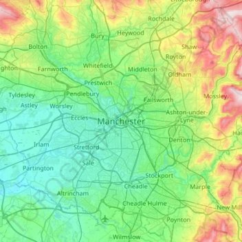
Name: Manchester topographic map, elevation, terrain.
Average elevation: 387 ft
Minimum elevation: 23 ft
Maximum elevation: 1,594 ft
Other topographic maps
Click on a map to view its topography, its elevation and its terrain.
Burnley
United Kingdom > England > Lancashire
The town lies in a natural three-forked valley at the confluence of the River Brun and the River Calder, surrounded by open fields, with wild moorland at higher altitudes. To the west of Burnley lie the towns of Padiham, Accrington and Blackburn, with Nelson and Colne to the north. The centre of the town…
Average elevation: 810 ft
Billington and Langho
United Kingdom > England > Lancashire > Ribble Valley > Brockhall Village
Average elevation: 190 ft
Colne Water
United Kingdom > England > Lancashire > Borough of Pendle > Laneshaw Bridge
Average elevation: 663 ft
River Ribble
United Kingdom > England > Lancashire
On the River Ribble, the tidal bore acts as a hydrodynamic "front," marking the abrupt transition from the prolonged low-water stand to a compressed flood tide. While the Irish Sea rises for over six hours, the narrowing 19th-century training walls funnel the tide into a singular surge, compressing the flood…
Average elevation: 669 ft
Melling-with-Wrayton
United Kingdom > England > Lancashire > Lancaster > Melling
Average elevation: 184 ft
River Irwell
United Kingdom > England > Lancashire
The River Irwell catchment area extends from the moors above Bacup to the Manchester Ship Canal. The climate of the catchment area is wetter than the UK average, with rainfall of 1,456 millimetres (57.3 in) per annum compared to 1,231 millimetres (48.5 in) per annum, and the rivers quickly respond to rainfall.…
Average elevation: 584 ft
Bispham
United Kingdom > England > Lancashire > West Lancashire > Bispham Green
Average elevation: 85 ft
Osbaldeston
United Kingdom > England > Lancashire > Ribble Valley > Osbaldeston
Average elevation: 243 ft
Up Holland
United Kingdom > England > Lancashire > West Lancashire > Upholland
Average elevation: 292 ft
Colne
United Kingdom > England > Lancashire > Borough of Pendle
Pendle Leisure Trust runs the Pendle Leisure Centre next to the railway station. The facility has two swimming pools, a fitness centre and gymnasium, sauna and sports hall. In summer 2013, the outdoor all-weather pitch was replaced by Urban Altitude. This outdoor aerial assault course is the first of its kind…
Average elevation: 646 ft
Bolton-le-Sands
United Kingdom > England > Lancashire > Lancaster > Bolton le Sands
Average elevation: 75 ft
Waddington
United Kingdom > England > Lancashire > Ribble Valley > Waddington
Average elevation: 538 ft
Aughton
United Kingdom > England > Lancashire > West Lancashire > Town Green
Average elevation: 128 ft
Scarisbrick
United Kingdom > England > Lancashire > West Lancashire > Scarisbrick
Average elevation: 39 ft
Clowbridge
United Kingdom > England > Lancashire > Borough of Rossendale > Habergham Eaves
Average elevation: 1,047 ft
Forest of Bowland National Landscape
United Kingdom > England > Lancashire
Contrary to the popular histories, the origins of the name "Bowland" have nothing to do with archery ("the land of the bow") or with mediaeval cattle farms or vaccaries (Old Norse, buu-, farmstead). The name derives from the Old Norse boga-/bogi-, meaning a "bend in a river". It is a 10th-century coinage used…
Average elevation: 623 ft
Brungerley Park
United Kingdom > England > Lancashire > Ribble Valley > Clitheroe > Waddington
Average elevation: 253 ft
Cowm Reservoir
United Kingdom > England > Lancashire > Borough of Rossendale > Whitworth > Shawforth
Average elevation: 991 ft
Nether Kellet
United Kingdom > England > Lancashire > Lancaster > Nether Kellet
Average elevation: 256 ft
Oswaldtwistle Moor
United Kingdom > England > Lancashire > Hyndburn > Green Haworth > Cocker Brook
Average elevation: 984 ft
Houghton Hagg Wood
United Kingdom > England > Lancashire > Burnley > Worsthorne
Average elevation: 630 ft
Singleton
United Kingdom > England > Lancashire > Borough of Fylde > Singleton
Average elevation: 43 ft
Laneshaw Bridge
United Kingdom > England > Lancashire > Borough of Pendle > Laneshaw Bridge
Average elevation: 883 ft