
Make a donation
Gear up for your next adventure:
As an Amazon Associate, this site earns from qualifying purchases at no extra cost to you.
Lake Witten topographic map
Click on the map to display elevation.
Make a donation
Gear up for your next adventure:
As an Amazon Associate, this site earns from qualifying purchases at no extra cost to you.
About this map
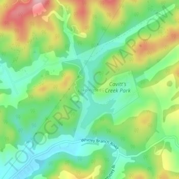
Name: Lake Witten topographic map, elevation, terrain.
Location: Lake Witten, Tazewell County, Virginia, United States (37.16566 -81.52159 37.17777 -81.51481)
Average elevation: 2,694 ft
Minimum elevation: 2,441 ft
Maximum elevation: 3,114 ft
Tazewell County trails, hiking, mountain biking, running and outdoor activities
Make a donation
Gear up for your next adventure:
As an Amazon Associate, this site earns from qualifying purchases at no extra cost to you.
Other topographic maps
Click on a map to view its topography, its elevation and its terrain.
Make a donation
Gear up for your next adventure:
As an Amazon Associate, this site earns from qualifying purchases at no extra cost to you.
Make a donation
Gear up for your next adventure:
As an Amazon Associate, this site earns from qualifying purchases at no extra cost to you.
Lamberts Store
United States > Virginia > Tazewell County > Lamberts Store
Average elevation: 2,356 ft