
Make a donation
Gear up for your next adventure:
As an Amazon Associate, this site earns from qualifying purchases at no extra cost to you.
Munich topographic map
Click on the map to display elevation.
Make a donation
Gear up for your next adventure:
As an Amazon Associate, this site earns from qualifying purchases at no extra cost to you.
Munich
Munich lies on the elevated plains of Upper Bavaria, about 50 km (31 mi) north of the northern edge of the Alps, at an altitude of about 520 m (1,706 ft) ASL. The local rivers are the Isar and the Würm. Munich is situated in the Northern Alpine Foreland. The northern part of this sandy plateau includes a highly fertile flint area which is no longer affected by the folding processes found in the Alps, while the southern part is covered with morainic hills. Between these are fields of fluvio-glacial out-wash, such as around Munich. Wherever these deposits get thinner, the ground water can permeate the gravel surface and flood the area, leading to marshes as in the north of Munich.
Make a donation
Gear up for your next adventure:
As an Amazon Associate, this site earns from qualifying purchases at no extra cost to you.
About this map
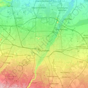
Name: Munich topographic map, elevation, terrain.
Location: Munich, Bavaria, Germany (48.06162 11.36078 48.24812 11.72291)
Average elevation: 1,719 ft
Minimum elevation: 1,529 ft
Maximum elevation: 2,077 ft
Make a donation
Gear up for your next adventure:
As an Amazon Associate, this site earns from qualifying purchases at no extra cost to you.
Other topographic maps
Click on a map to view its topography, its elevation and its terrain.
Neumühle
Germany > Bavaria > Landkreis Neustadt an der Waldnaab > Hammerles
Average elevation: 1,516 ft
Make a donation
Gear up for your next adventure:
As an Amazon Associate, this site earns from qualifying purchases at no extra cost to you.
Bruck in der Oberpfalz
Germany > Bavaria > Landkreis Schwandorf > Bruck i.d.OPf.
Average elevation: 1,325 ft
Ruine Falkenstein
Germany > Bavaria > Landkreis Ostallgäu > Pfronten > Benken
Originally known as Castrum Pfronten, the stone castle was built approximately 1270–1280 by Count Meinhard II of Tyrol on the borders of his land. Because of the unusual situation of the castle it has been interpreted in historical context as a symbol of opposition to the Duchy of Bavaria. (During the winter…
Average elevation: 3,084 ft
Hopfensee-Achen
Germany > Bavaria > Landkreis Ostallgäu > Füssen > Hopfen am See
Average elevation: 2,654 ft
Königshaus am Schachen
Germany > Bavaria > Landkreis Garmisch-Partenkirchen > Garmisch-Partenkirchen
The King's House on Schachen is located at Schachen, at an altitude with a view of the dramatic mountain backdrop of the Wetterstein Formation, about 10 km south of Garmisch-Partenkirchen, Bavaria. It can only be reached via a 10 km forest road, or a three-hour hike, ascending 1000m either from Schloss Elmau…
Average elevation: 5,344 ft
Make a donation
Gear up for your next adventure:
As an Amazon Associate, this site earns from qualifying purchases at no extra cost to you.
Neuschwanstein Castle
Germany > Bavaria > Landkreis Ostallgäu > Hohenschwangau
The municipality of Schwangau lies at an elevation of 800 m (2,620 ft) at the southwest border of the German state of Bavaria. Its surroundings are characterised by the transition between the Alpine foothills in the south (toward the nearby Austrian border) and a hilly landscape in the north that appears flat…
Average elevation: 3,222 ft
Make a donation
Gear up for your next adventure:
As an Amazon Associate, this site earns from qualifying purchases at no extra cost to you.
Make a donation
Gear up for your next adventure:
As an Amazon Associate, this site earns from qualifying purchases at no extra cost to you.
Möding
Germany > Bavaria > Landkreis Dingolfing-Landau > Landau an der Isar
Average elevation: 1,362 ft
Make a donation
Gear up for your next adventure:
As an Amazon Associate, this site earns from qualifying purchases at no extra cost to you.
Neuschwanstein Castle
Germany > Bavaria > Landkreis Ostallgäu > Hohenschwangau
The municipality of Schwangau lies at an elevation of 800 m (2,620 ft) at the southwest border of the German state of Bavaria. Its surroundings are characterised by the transition between the Alpine foothills in the south (toward the nearby Austrian border) and a hilly landscape in the north that appears flat…
Average elevation: 3,222 ft
Drosendorf an der Aufseß
Germany > Bavaria > Landkreis Bayreuth > Hollfeld
Average elevation: 1,460 ft
Make a donation
Gear up for your next adventure:
As an Amazon Associate, this site earns from qualifying purchases at no extra cost to you.
Make a donation
Gear up for your next adventure:
As an Amazon Associate, this site earns from qualifying purchases at no extra cost to you.
Listsee
Germany > Bavaria > Landkreis Berchtesgadener Land > Bad Reichenhall
Average elevation: 2,615 ft
Kampenwand-Hauptgipfel
Germany > Bavaria > Landkreis Rosenheim > Aschau im Chiemgau
Average elevation: 4,173 ft
Make a donation
Gear up for your next adventure:
As an Amazon Associate, this site earns from qualifying purchases at no extra cost to you.
Heimgarten
Germany > Bavaria > Landkreis Garmisch-Partenkirchen > Ohlstadt
Heimgarten (elevation 1,790 metres/5,870 ft) is a mountain near Ohlstadt in the Bavarian Prealps of southern Germany. It is connected via a ridge with Herzogstand (1,731 metres/5,679 ft) to the east.
Average elevation: 4,403 ft
Make a donation
Gear up for your next adventure:
As an Amazon Associate, this site earns from qualifying purchases at no extra cost to you.
Holdenried
Germany > Bavaria > Landkreis Oberallgäu > Wiggensbach > Wiggensbach
Average elevation: 2,966 ft
Zugspitze
Germany > Bavaria > Landkreis Garmisch-Partenkirchen > Grainau
The mountain rises eleven kilometres southwest of Garmisch-Partenkirchen and just under six kilometres east of Ehrwald. The border between Germany and Austria runs over the west summit; thus the Zugspitze massif belongs to the German state of Bavaria and the Austrian state of Tyrol. The municipalities…
Average elevation: 7,546 ft
Make a donation
Gear up for your next adventure:
As an Amazon Associate, this site earns from qualifying purchases at no extra cost to you.
Make a donation
Gear up for your next adventure:
As an Amazon Associate, this site earns from qualifying purchases at no extra cost to you.
Geroldsee (Wagenbrüchsee)
Germany > Bavaria > Landkreis Garmisch-Partenkirchen > Gerold
Average elevation: 3,412 ft
Kramerspitz
Germany > Bavaria > Landkreis Garmisch-Partenkirchen > Garmisch-Partenkirchen
Average elevation: 4,718 ft
Make a donation
Gear up for your next adventure:
As an Amazon Associate, this site earns from qualifying purchases at no extra cost to you.
Make a donation
Gear up for your next adventure:
As an Amazon Associate, this site earns from qualifying purchases at no extra cost to you.
Make a donation
Gear up for your next adventure:
As an Amazon Associate, this site earns from qualifying purchases at no extra cost to you.
Willmersbach
Germany > Bavaria > Landkreis Neustadt an der Aisch-Bad Windsheim
Average elevation: 1,106 ft
Make a donation
Gear up for your next adventure:
As an Amazon Associate, this site earns from qualifying purchases at no extra cost to you.
Make a donation
Gear up for your next adventure:
As an Amazon Associate, this site earns from qualifying purchases at no extra cost to you.
Make a donation
Gear up for your next adventure:
As an Amazon Associate, this site earns from qualifying purchases at no extra cost to you.
Deisenhofen
Germany > Bavaria > Landkreis Dillingen an der Donau > Höchstädt an der Donau
Average elevation: 1,407 ft
Make a donation
Gear up for your next adventure:
As an Amazon Associate, this site earns from qualifying purchases at no extra cost to you.
Wind
Germany > Bavaria > Landkreis Bamberg
Winds can shape landforms, via a variety of aeolian processes such as the formation of fertile soils, for example loess, and by erosion. Dust from large deserts can be moved great distances from its source region by the prevailing winds; winds that are accelerated by rough topography and associated with dust…
Average elevation: 932 ft
Schachen
Germany > Bavaria > Landkreis Garmisch-Partenkirchen > Garmisch-Partenkirchen
Average elevation: 5,367 ft
Make a donation
Gear up for your next adventure:
As an Amazon Associate, this site earns from qualifying purchases at no extra cost to you.
Schloss Sinning
Germany > Bavaria > Landkreis Neuburg-Schrobenhausen > Sinning
Average elevation: 1,417 ft
Make a donation
Gear up for your next adventure:
As an Amazon Associate, this site earns from qualifying purchases at no extra cost to you.
Make a donation
Gear up for your next adventure:
As an Amazon Associate, this site earns from qualifying purchases at no extra cost to you.
Ziegelhütte
Germany > Bavaria > Landkreis Wunsiedel im Fichtelgebirge > Marktredwitz
Average elevation: 1,847 ft
Make a donation
Gear up for your next adventure:
As an Amazon Associate, this site earns from qualifying purchases at no extra cost to you.
Partnach Gorge
Germany > Bavaria > Landkreis Garmisch-Partenkirchen > Garmisch-Partenkirchen > Vordergraseck
Average elevation: 3,294 ft
Make a donation
Gear up for your next adventure:
As an Amazon Associate, this site earns from qualifying purchases at no extra cost to you.
Make a donation
Gear up for your next adventure:
As an Amazon Associate, this site earns from qualifying purchases at no extra cost to you.
Make a donation
Gear up for your next adventure:
As an Amazon Associate, this site earns from qualifying purchases at no extra cost to you.