Geolocate

Maharashtra topographic map

Interactive map

Click on the map to display elevation.

Maharashtra

Maharashtra with a total area of 307,713 km2 (118,809 sq mi), is the third-largest state by area in terms of land area and constitutes 9.36 per cent of India's total geographical area. The State lies between 15°35' N to 22°02' N latitude and 72°36' E to 80°54' E longitude. It occupies the western and central part of the country and has a coastline stretching 840 kilometres along the Arabian Sea. The dominant physical feature of the state is its plateau character, which is separated from the Konkan coastline by the mountain range of the Western Ghats, which runs parallel to the coast from north to south.The Western Ghats, also known as the Sahyadri Range, has an average elevation of 1,200 metres (4,000 ft); its slopes gently descending towards the east and southeast. The Western Ghats (or the Sahyadri Mountain range) provide a physical barrier to the state on the west, while the Satpura Hills along the north and Bhamragad-Chiroli-Gaikhuri ranges on the east serve as its natural borders. This state's expansion from North to South is 700 km and East to West is 800 km. To the west of these hills lie the Konkan coastal plains, 50–80 kilometres in width. To the east of the Ghats lies the flat Deccan Plateau. The main rivers of the state are the Krishna, and its tributary, Bhima, the Godavari, and its main tributaries, Manjara, and Wardha-Wainganga and the Tapi, and its tributary Purna. Maharashtra is divided into five geographic regions. Konkan is the western coastal region, between the Western Ghats and the sea. Khandesh is the north region lying in the valley of the Tapti, Purna river. Nashik, Malegaon Jalgaon, Dhule and Bhusawal are the major cities of this region. Desh is in the center of the state. Marathwada, which was a part of the princely state of Hyderabad until 1956, is located in the southeastern part of the state. Aurangabad and Nanded are the main cities of the region. Vidarbha is the easternmost region of the state, formerly part of the Central Provinces and Berar.

Wikipedia (CC-BY-SA 3.0)

About this map

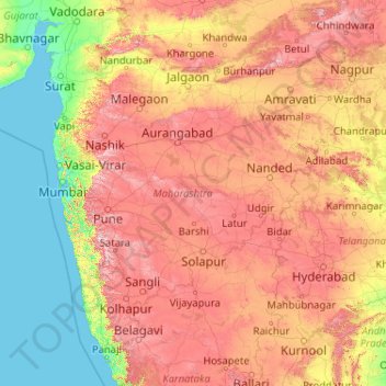
Name: Maharashtra topographic map, elevation, terrain.

Location: Maharashtra, India (15.60636 72.65261 22.03027 80.89778)

Average elevation: 1,135 ft

Minimum elevation: -3 ft

Maximum elevation: 4,652 ft

Other topographic maps

Click on a map to view its topography, its elevation and its terrain.

Pettamala

India > Kerala > Kunnathunad

Average elevation: 75 ft

Noida

India > Uttar Pradesh > Dadri

Average elevation: 709 ft

Ooty Lake

India > Tamil Nadu > Udhagamandalam > Udhagamandalam

Average elevation: 7,333 ft

Mangaluru

India > Karnataka > Mangaluru taluk

Mangalore is also the administrative headquarters of the Dakshina Kannada district; it is a commercial, industrial, educational, healthcare, and startup hub. The city's international airport is the second-largest and second-busiest airport in Karnataka. Mangalore City Corporation is responsible for the civic…

Average elevation: 82 ft

3d

India > Rajasthan > Ganganagar Tehsil > 1 LNP

Average elevation: 584 ft

Coimbatore

India > Tamil Nadu > Coimbatore North

Average elevation: 1,483 ft

Udupi

India > Karnataka > Udupi taluku

Udupi has an elevation of 27 m (89 ft) above mean sea level. The climate in Udupi is hot in summers and pleasant in winter. During summers (from March to May) the temperature reaches up to 38 °C (100 °F) and in winters (from December to February) it is usually between 32 and 20 °C (90 and 68 °F). As it is…

Average elevation: 56 ft

Madurai

India > Tamil Nadu > Madurai

Madurai is located at 9°56′N 78°07′E / 9.93°N 78.12°E / 9.93; 78.12. It has an average elevation of 101 metres. The city of Madurai lies on the flat and fertile plain of the river Vaigai, which runs in the northwest-southeast direction through the city, dividing it into two almost equal…

Average elevation: 453 ft

Thenzawl

India > Serchhip

Average elevation: 2,421 ft

Akeda Chaud

India > Rajasthan > Chomu Tehsil > Jaitpura

Average elevation: 1,545 ft

Kalamboli

India > Maharashtra > Malshiras

Average elevation: 1,657 ft

Indian subcontinent

India > Maharashtra > Arni

Average elevation: 1,155 ft

Lucknow

India > Uttar Pradesh > Lucknow

Lucknow stands at an elevation of approximately 123 metres (404 ft) above sea level. The city had an area of 402 km2 (155 square miles) until December 2019, when 88 villages were added to the municipal limits and the area increased to 631 km2 (244 square miles). Bounded on the east by Barabanki, on the west by…

Average elevation: 394 ft

Varanasi

India > Uttar Pradesh > Sadar

Varanasi is located at an elevation of 80.71 metres (264.8 ft) in the centre of the Ganges valley of North India, in the Eastern part of the state of Uttar Pradesh, along the left crescent-shaped bank of the Ganges, averaging between 15 metres (50 ft) and 21 metres (70 ft) above the river. The city is the…

Average elevation: 253 ft

Musi River

India > Telangana > Hyderabad

Average elevation: 1,608 ft

Bhopal

India > Madhya Pradesh > Huzur Tahsil

Bhopal has an average elevation of 500 metres (1401 ft) and is located in the central part of India, just north of the upper limit of the Vindhya mountain ranges. Located on the Malwa plateau, it is higher than the north Indian plains and the land rises towards the Vindhya Range to the south. The city has…

Average elevation: 1,634 ft

Umreth

India > Gujarat > Umreth Taluka

Average elevation: 171 ft

Jagatsukh

India > Himachal Pradesh > Manali

Average elevation: 6,893 ft

Velsao Beach

India > Goa > Mormugao

Average elevation: 23 ft

Kolhapur

India > Maharashtra > Karvir

Kolhapur is an inland city located in south-west Maharashtra state, 373 km (232 mi) south of Mumbai and 228 km (142 mi) south of Pune, 615 km (382 mi) north-west of Bengaluru and 530 km (330 mi) west of Hyderabad. Within Maharashtra, Kolhapur's nearest cities and towns are Ichalkaranji 27 km (17 mi), Kodoli 35…

Average elevation: 1,942 ft

Dharavi

India > Maharashtra > Mumbai

Average elevation: 20 ft

Mysuru

India > Karnataka > Mysuru taluk

Mysore (/maɪˈsɔːr/ (listen)), officially Mysuru ([ˈmaɪˈsuːɾu] (listen)), is a city in the southern part of the state of Karnataka, India. Mysore city is geographically located between 12° 18′ 26″ north latitude and 76° 38′ 59″ east longitude. It is located at an altitude of 770 m (2,530 ft)…

Average elevation: 2,385 ft

Indore

India > Madhya Pradesh > Juni Indore Tahsil

Indore /ɪnˈdɔːr/ (listen) is the most populous and the largest city in the Indian state of Madhya Pradesh. It serves as the headquarters of both Indore District and Indore Division. It is also considered as an education hub of the state and has campuses of both the Indian Institute of Technology and the…

Average elevation: 1,821 ft

Jodhpur

India > Rajasthan > Jodhpur Tehsil

Average elevation: 781 ft

Dudhwa National Park

India > Uttar Pradesh > Palia

Dudhwa National Park is located in Lakhimpur Kheri district of Uttar Pradesh. The area of the park falls within the Upper Gangetic plains and is a vast alluvial plain ranging in elevation from 150 m (490 ft) in the farthest southeast to 182 m (597 ft) in the north.

Average elevation: 535 ft

Nagampalli

India > Tamil Nadu > Aravakurichi

Average elevation: 515 ft

Bitherkad

India > Tamil Nadu > Pandalur

Average elevation: 3,087 ft

Kargudi

India > Tamil Nadu > Gudalur

Average elevation: 3,031 ft

Karungalapalli

India > Tamil Nadu > Kulithalai

Average elevation: 305 ft

Subramaniyapuram

India > Tamil Nadu > Kulithalai > Kattanimedu

Average elevation: 299 ft

Islampur

India > West Bengal > Islampur

Average elevation: 207 ft

Miryalaguda

India > Telangana > Miryalaguda mandal

Average elevation: 436 ft

Lucknow

India > Uttar Pradesh > Lucknow

The city stands at an elevation of approximately 123 metres (404 ft) above sea level. Lucknow city had an area of 402 km2 (155 square miles) till December 2019, when 88 villages were added to the municipal limits and the area increased to 631 km2 (244 square miles). Bounded on the east by Barabanki, on the…

Average elevation: 394 ft

Navi Mumbai

India > Maharashtra > Thane > Navi Mumbai

Navi Mumbai (Marathi pronunciation: , also known by its former name New Bombay), is a planned city off the west coast of the Indian state of Maharashtra in Konkan division. The city is divided into two parts, North Navi Mumbai and South Navi Mumbai, for the individual development of Panvel Mega City, which…

Average elevation: 98 ft

Vadodara

India > Gujarat > Vadodara Rural Taluka

Vadodara is located at 22°18′N 73°11′E / 22.30°N 73.19°E / 22.30; 73.19 in western India at an elevation of 39 metres (128 ft). It is the tenth-largest city in India with an area of 400 square kilometres (150 sq mi) and a population of 3.5 million, according to the 2010–11 census. The city…

Average elevation: 118 ft

Kochi

India > Kerala > Kochi

Average elevation: 13 ft

Mandur

India > Maharashtra > Shirala

Average elevation: 2,139 ft

Kolthur

India > Telangana > Muduchinthalapally

Average elevation: 1,827 ft

Nilakkottai

India > Tamil Nadu > Nilakkottai

Nilakkottai is located at 10°10′N 77°51′E / 10.17°N 77.85°E / 10.17; 77.85. It has an average elevation of 320 metres (1049 feet).

Average elevation: 794 ft

Poyyamani

India > Tamil Nadu > Kulithalai

Average elevation: 285 ft

Manganur

India > Telangana > Bijinapalle mandal

Average elevation: 1,624 ft

Kamorta

India > Andaman and Nicobar Islands > Nancowry

Average elevation: 23 ft

Ranaghat

India > Arunachal Pradesh > Aalo HQ

Average elevation: 1,299 ft

Tamluk

India > West Bengal > Tamluk

Average elevation: 10 ft

Kuzhimattom

India > Kerala > Kottayam

Average elevation: 62 ft

Nemam

India > Tamil Nadu > Poonamallee

Average elevation: 98 ft

Chandak

India > Uttarakhand > Pithoragarh Tehsil > Chandak

Average elevation: 5,725 ft

Madakkathanam

India > Kerala > Muvattupuzha

Average elevation: 174 ft

Mastari

India > Uttarakhand > Bhatwari > Thalan

Average elevation: 5,400 ft

Silpata

India > Rajasthan > Kotkasim Tehsil

Average elevation: 840 ft

Jolarpet

India > Tamil Nadu > Tirupathur

Jolarpet is a second grade municipality in Tirupattur district. Jolarpet is renowned for its railway station. The town is also located on State Highway 18 connecting Vaniyambadi -Tirupattur. Regarding transportation linkage, the highway (NH 48) from Chennai to Krishnagiri passes through the outskirts of the…

Average elevation: 1,617 ft

Chennai

India > Tamil Nadu

Chennai is located on the south–eastern coast of India in the north–eastern part of Tamil Nadu on a flat coastal plain known as the Eastern Coastal Plains. Its average elevation is around 6.7 metres (22 ft), and its highest point is 60 m (200 ft). Chennai is 2,184 kilometres (1,357 mi) south of Delhi,…

Average elevation: 23 ft

Mangraun

India > Uttarakhand > Thailisain > Jogimandi

Average elevation: 5,758 ft

Elavoor Kavala

India > Kerala > Aluva > Karayamparambu

Average elevation: 59 ft

Devanahalli

India > Karnataka > Devanahalli taluku

Average elevation: 2,953 ft

Shimla

India > Himachal Pradesh > Shimla (urban)

Shimla is on the south-western ranges of the Himalayas at 31°37′N 77°06′E / 31.61°N 77.10°E / 31.61; 77.10. It has an average altitude of 2,206 metres (7,238 ft) above mean sea level and extends along a ridge with seven spurs. The city stretches nearly 9.2 kilometres (5.7 mi) from east to west.

Average elevation: 5,108 ft

Ahmedabad

India > Gujarat

Average elevation: 164 ft

Surat

India > Gujarat > Katargam Taluka > Surat

Surat is a port city situated on the banks of the Tapi river. Damming of the Tapi caused the original port facilities to close; the nearest port is now in the Magadalla and Hazira area of Surat Metropolitan Region.It has famous beach called 'Dumas Beach' located in Hazira. The city is located at 21°10′N…

Average elevation: 36 ft

Guwahati

India > Assam > Guwahati

Professor Abani Kumar Bhagawati of Gauhati University stated that since before there were sufficient wetlands to absorb rainwater and channels to carry excess water to the Brahmaputra, the city did not experience floods. However, human interference has disrupted the natural topography, leading to the current…

Average elevation: 371 ft

Dehradun

India > Uttarakhand > Dehradun

The city of Dehradun mainly lies in Doon Valley and is at a varying height from 410 m (1,350 ft) in Clement Town to above 700 m (2,300 ft) at Malsi which is 15 km (9.3 mi) from the city. However, the average elevation is 450 m (1,480 ft) above sea level. Malsi is the starting point of Lesser Himalayan Range…

Average elevation: 2,966 ft

Jaipur

India > Rajasthan > Jaipur Tehsil

Average elevation: 1,339 ft

Harda Tadiyal

India > Uttarakhand > Molekhal > Harara

Average elevation: 3,409 ft

Pantwari

India > Uttarakhand > Dhanaulti

Average elevation: 5,266 ft

Hadinaru

India > Karnataka > Nanjanagudu taluk

Average elevation: 2,182 ft

Ratchandana

India > Maharashtra > Yavatmal

Average elevation: 1,289 ft

Ambaji

India > Gujarat > Danta Taluka

Ambaji is a town within taluka district Banaskantha, North Gujarat, India. It is located at 24°20′N 72°51′E / 24.33°N 72.85°E / 24.33; 72.85. It is at an altitude of 480 metres (1,570 ft). It is surrounded by the Araveli Hill range. Ambaji is within the Aravali Range'line of peaks', is a range…

Average elevation: 1,486 ft

oddi

India > Maharashtra > Mangalvedhe

Average elevation: 1,575 ft

Cheruthuruthy

India > Kerala > Talappilly

Average elevation: 121 ft

Raigad Fort

India > Maharashtra > Mahad Taluka > Hirkaniwadi

Average elevation: 1,476 ft

Dharamshala

India > Himachal Pradesh > Dharamshala

Dharamshala has an average elevation of 1,457 m (4,780 ft), covering an area of almost 8.51 km2 (3.29 sq mi). Dharamsala is located in the Kangra Valley, in the shadow of the Dhauladhar mountains.

Average elevation: 5,843 ft

Thiruvananthapuram

India > Kerala > Thiruvananthapuram

Thiruvananthapuram is built on seven hills by the seashore and is at 8°30′N 76°54′E / 8.5°N 76.9°E / 8.5; 76.9 on the west coast, near the southern tip of mainland India. The city is on the west coast of India and is bounded by the Laccadive Sea to its west and the Western Ghats to its east.…

Average elevation: 108 ft

Ranchi

India > Jharkhand > Kanke

Ranchi lies at 23°22′N 85°20′E / 23.36°N 85.33°E / 23.36; 85.33 near to the Tropic of Cancer. The city covers an area of 175 km2 (68 sq mi) and its average elevation is 651 m above sea level. Ranchi is located in the southern part of the Chota Nagpur plateau, which is the eastern section of…

Average elevation: 2,126 ft

Ahmedabad

India > Gujarat

Average elevation: 164 ft

Binak

India > Uttarakhand > Yamkeshwar

Average elevation: 3,130 ft

Kandlamadugu

India > Andhra Pradesh > B. Kothakota

Average elevation: 2,743 ft

Ainavolu

India > Andhra Pradesh > Thullur > Amaravati

Average elevation: 72 ft

Gonuguntlavaripalem

India > Andhra Pradesh > Vinukonda

Average elevation: 213 ft

Ampapuram

India > Andhra Pradesh > Bapulapadu

Average elevation: 59 ft

Bhavanipuram

India > Andhra Pradesh

Average elevation: 89 ft

Gollapudi

India > Andhra Pradesh > Vijayawada (Rural)

Average elevation: 69 ft

Avanigadda

India > Andhra Pradesh > Avanigadda

Average elevation: 23 ft

Gudavalli

India > Andhra Pradesh > Vijayawada (Rural)

Average elevation: 49 ft

Nunna

India > Andhra Pradesh > Vijayawada (Rural)

Average elevation: 98 ft

Gudavalli

India > Andhra Pradesh > Cherukupalle

Average elevation: 20 ft

Chellanam

India > Kerala > Kochi

Average elevation: 7 ft

Palolipalam

India > Kerala > Vadakara

Average elevation: 39 ft

Alinjivakkam

India > Tamil Nadu > Mathavaram

Average elevation: 33 ft

Pandaravadi

India > Tamil Nadu > Mayiladuthurai

Average elevation: 39 ft

Kali Khol

India > Rajasthan > Alwar Tehsil

Average elevation: 1,312 ft

Chengalpattu

India > Tamil Nadu > Chengalpattu

Chengalpattu is located at 12°42′N 79°59′E / 12.7°N 79.98°E / 12.7; 79.98. It has an average elevation of 36 metres (118 ft). Lake Kolavai is the largest located in Chengalpattu.

Average elevation: 157 ft

Kangra

India > Himachal Pradesh

Average elevation: 5,463 ft

Gosala

India > Andhra Pradesh > Penamaluru

Average elevation: 56 ft

Kodungallur

India > Kerala > Kodungallur

Average elevation: 16 ft

Kanheri Caves

India > Maharashtra > Mumbai

Average elevation: 554 ft

Kumalti

India > Uttarakhand > Bhatwari

Average elevation: 6,079 ft

Chikkamagaluru

India > Karnataka > Chikkamagaluru taluku

Chikmagalur is situated in the Malenadu region of Karnataka in the Deccan plateau in the foothills of the Western Ghats. It is situated at an elevation of 1,090 metres (3,580 ft) above mean sea level, meaning, it is the third highest city in Karnataka. The Yagachi River has its source near the town and flows…

Average elevation: 3,451 ft

Panachamoodu

India > Kerala > Neyyattinkara

Average elevation: 387 ft