
Banten topographic map
Interactive map
Click on the map to display elevation.
Banten
The province ranges in altitude from sea level to 2,000 m (6,600 ft). Banten is primarily lowland (below 50 metres above sea level) in Cilegon, Tangerang, Pandeglang Regency, and most of Serang Regency. The central Lebak and Pandeglang Regencies range from 201 to 2,000 m (659 to 6,562 ft), and the eastern Lebak Regency ranges in altitude from 501 to 2,000 m (1,644 to 6,562 ft) at the summit of Mount Halimun.
About this map
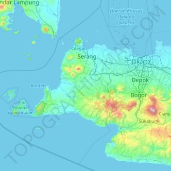
Name: Banten topographic map, elevation, terrain.
Location: Banten, Java, Indonesia (-7.45659 104.65132 -5.49964 106.78001)
Average elevation: 384 ft
Minimum elevation: -7 ft
Maximum elevation: 9,760 ft
Other topographic maps
Click on a map to view its topography, its elevation and its terrain.