
Marshall topographic map
Interactive map
Click on the map to display elevation.
About this map
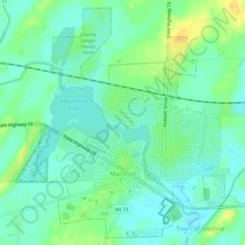
Name: Marshall topographic map, elevation, terrain.
Location: Marshall, Dane County, Wisconsin, United States (43.16026 -89.08159 43.18916 -89.03937)
Average elevation: 869 ft
Minimum elevation: 833 ft
Maximum elevation: 935 ft
Dane County trails, hiking, mountain biking, running and outdoor activities
Other topographic maps
Click on a map to view its topography, its elevation and its terrain.
Madison
United States > Wisconsin > Dane County
The city is sometimes described as The City of Four Lakes, comprising the four successive lakes of the Yahara River: Lake Mendota ("Fourth Lake"), Lake Monona ("Third Lake"), Lake Waubesa ("Second Lake") and Lake Kegonsa ("First Lake"), although Waubesa and Kegonsa are not actually in Madison, but just south…
Average elevation: 948 ft
Springfield Corners
United States > Wisconsin > Dane County > Town of Springfield
Average elevation: 1,040 ft
West Middleton
United States > Wisconsin > Dane County > Town of Middleton
Average elevation: 1,112 ft
Glacial Valley Park
United States > Wisconsin > Dane County > Village of Cross Plains
Average elevation: 942 ft
Taylors Corners
United States > Wisconsin > Dane County > Village of Cottage Grove
Average elevation: 909 ft
Indian Lake County Park
United States > Wisconsin > Dane County > Town of Berry
Average elevation: 1,037 ft