
Huizhou topographic map
Interactive map
Click on the map to display elevation.
About this map
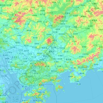
Name: Huizhou topographic map, elevation, terrain.
Location: Huizhou, Guangdong Province, China (22.25733 113.80863 23.96288 115.42155)
Average elevation: 440 ft
Minimum elevation: -23 ft
Maximum elevation: 4,085 ft
Other topographic maps
Click on a map to view its topography, its elevation and its terrain.
Guangzhou
China > Guangdong Province > Guangzhou
The elevation of the prefecture generally increases from southwest to northeast, with mountains forming the backbone of the city and the ocean comprising the front. Tiantang Peak (天堂顶, "Heavenly Peak") is the highest point of elevation at 1,210 metres (3,970 ft) above sea level.
Average elevation: 69 ft