
Make a donation
Gear up for your next adventure:
As an Amazon Associate, this site earns from qualifying purchases at no extra cost to you.
Davidson topographic map
Click on the map to display elevation.
Make a donation
Gear up for your next adventure:
As an Amazon Associate, this site earns from qualifying purchases at no extra cost to you.
About this map
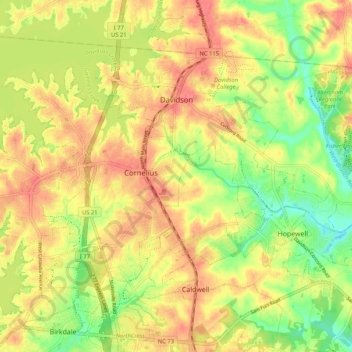
Name: Davidson topographic map, elevation, terrain.
Location: Davidson, Mecklenburg County, North Carolina, United States (35.44246 -80.87245 35.51934 -80.76876)
Average elevation: 764 ft
Minimum elevation: 650 ft
Maximum elevation: 850 ft
Mecklenburg County trails, hiking, mountain biking, running and outdoor activities
Make a donation
Gear up for your next adventure:
As an Amazon Associate, this site earns from qualifying purchases at no extra cost to you.
Other topographic maps
Click on a map to view its topography, its elevation and its terrain.
Carmel Woods
United States > North Carolina > Mecklenburg County > Charlotte
Average elevation: 633 ft
Orchard Park
United States > North Carolina > Mecklenburg County > Charlotte
Average elevation: 751 ft
Make a donation
Gear up for your next adventure:
As an Amazon Associate, this site earns from qualifying purchases at no extra cost to you.
Griffith Lakes
United States > North Carolina > Mecklenburg County > Charlotte
Average elevation: 801 ft
Spring Valley
United States > North Carolina > Mecklenburg County > Charlotte
Average elevation: 659 ft
Make a donation
Gear up for your next adventure:
As an Amazon Associate, this site earns from qualifying purchases at no extra cost to you.
Providence Plantation
United States > North Carolina > Mecklenburg County > Charlotte
Average elevation: 673 ft
Make a donation
Gear up for your next adventure:
As an Amazon Associate, this site earns from qualifying purchases at no extra cost to you.
Carolina Harbor
United States > North Carolina > Mecklenburg County > Charlotte
Average elevation: 614 ft
Ballantyne's Backyard
United States > North Carolina > Mecklenburg County > Charlotte
Average elevation: 600 ft
Old Providence
United States > North Carolina > Mecklenburg County > Charlotte
Average elevation: 630 ft
Make a donation
Gear up for your next adventure:
As an Amazon Associate, this site earns from qualifying purchases at no extra cost to you.
Tuckaseegee Park
United States > North Carolina > Mecklenburg County > Charlotte
Average elevation: 764 ft
Sharon Colony
United States > North Carolina > Mecklenburg County > Charlotte
Average elevation: 659 ft
Make a donation
Gear up for your next adventure:
As an Amazon Associate, this site earns from qualifying purchases at no extra cost to you.
Reedy Creek Regional Park
United States > North Carolina > Mecklenburg County > Charlotte
Average elevation: 751 ft
Providence Plantation
United States > North Carolina > Mecklenburg County > Charlotte
Average elevation: 673 ft
Make a donation
Gear up for your next adventure:
As an Amazon Associate, this site earns from qualifying purchases at no extra cost to you.
Park on Wilgrove
United States > North Carolina > Mecklenburg County > Charlotte > Lakeland Hills
Average elevation: 761 ft
Providence Plantation
United States > North Carolina > Mecklenburg County > Charlotte
Average elevation: 673 ft
Make a donation
Gear up for your next adventure:
As an Amazon Associate, this site earns from qualifying purchases at no extra cost to you.
Montclaire South
United States > North Carolina > Mecklenburg County > Charlotte
Average elevation: 663 ft
Make a donation
Gear up for your next adventure:
As an Amazon Associate, this site earns from qualifying purchases at no extra cost to you.
Providence Plantation
United States > North Carolina > Mecklenburg County > Charlotte > Providence Plantation
Average elevation: 656 ft
Coulwood Hills
United States > North Carolina > Mecklenburg County > Charlotte > Coulwood Hills
Average elevation: 699 ft
Make a donation
Gear up for your next adventure:
As an Amazon Associate, this site earns from qualifying purchases at no extra cost to you.