
Make a donation
Gear up for your next adventure:
As an Amazon Associate, this site earns from qualifying purchases at no extra cost to you.
Metropolitan France topographic map
Click on the map to display elevation.
Make a donation
Gear up for your next adventure:
As an Amazon Associate, this site earns from qualifying purchases at no extra cost to you.
About this map
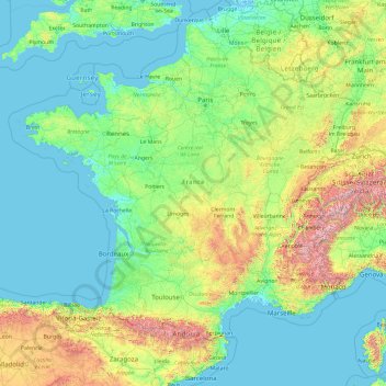
Name: Metropolitan France topographic map, elevation, terrain.
Location: Metropolitan France, France (41.26112 -5.45177 51.30557 9.82822)
Average elevation: 984 ft
Minimum elevation: -10 ft
Maximum elevation: 13,632 ft
Make a donation
Gear up for your next adventure:
As an Amazon Associate, this site earns from qualifying purchases at no extra cost to you.
Other topographic maps
Click on a map to view its topography, its elevation and its terrain.
Paris
Paris in its early history had only the rivers Seine and Bièvre for water. From 1809, the Canal de l'Ourcq provided Paris with water from less-polluted rivers to the north-east of the capital. From 1857, the civil engineer Eugène Belgrand, under Napoleon III, oversaw the construction of a series of new…
Average elevation: 246 ft
Make a donation
Gear up for your next adventure:
As an Amazon Associate, this site earns from qualifying purchases at no extra cost to you.
Danton
France > Auvergne-Rhône-Alpes > Ardèche > Saint-Sauveur-de-Montagut
Average elevation: 1,588 ft
Make a donation
Gear up for your next adventure:
As an Amazon Associate, this site earns from qualifying purchases at no extra cost to you.
Make a donation
Gear up for your next adventure:
As an Amazon Associate, this site earns from qualifying purchases at no extra cost to you.
Plage du Canon
France > Provence-Alpes-Côte d'Azur > Var > Saint-Mandrier-sur-Mer
Average elevation: 59 ft
Make a donation
Gear up for your next adventure:
As an Amazon Associate, this site earns from qualifying purchases at no extra cost to you.
Bayonne
France > New Aquitaine > Pyrénées-Atlantiques > Bayonne > Bayonne
In the late Quaternary, the current topographic physiognomy was formed—i.e. a set of hills overlooking a swampy lowland. The promontory of Bassussarry–Marracq ultimately extended to the Labourdin foothills. The Grand Bayonne hill is an example. Similarly, on the right bank of the Nive, the heights of…
Average elevation: 75 ft
Make a donation
Gear up for your next adventure:
As an Amazon Associate, this site earns from qualifying purchases at no extra cost to you.
Serre Chevalier
France > Provence-Alpes-Côte d'Azur > Hautes-Alpes > Puy-Saint-André
The maximum elevation for skiing is at Telesiege Yret at 2,800 m (9,190 ft) above sea level, and the minimum is 1,200 m (3,940 ft), a total vertical drop of 1,600 m (5,250 ft). One of the outstanding features of Serre Chevalier is the wooded nature of the slopes. The timber line is at 2,150 m (7,050 ft),…
Average elevation: 7,402 ft
Make a donation
Gear up for your next adventure:
As an Amazon Associate, this site earns from qualifying purchases at no extra cost to you.
La Vieille-Ville
France > Pays de la Loire > Loire-Atlantique > La Chapelle-Glain
Average elevation: 236 ft
Col de Nice
France > Provence-Alpes-Côte d'Azur > Maritime Alps > L'Escarène
Average elevation: 1,463 ft
Make a donation
Gear up for your next adventure:
As an Amazon Associate, this site earns from qualifying purchases at no extra cost to you.
Etang des Lames
France > Bourgogne – Franche-Comté > Yonne > Island > La Courcelle
Average elevation: 922 ft
Mollard Durand
France > Auvergne-Rhône-Alpes > Savoy > Saint-Martin-de-la-Porte
Average elevation: 3,445 ft
Make a donation
Gear up for your next adventure:
As an Amazon Associate, this site earns from qualifying purchases at no extra cost to you.
Pièce de Givry
France > Centre-Val de Loire > Indre-et-Loire > Athée-sur-Cher
Average elevation: 302 ft
Make a donation
Gear up for your next adventure:
As an Amazon Associate, this site earns from qualifying purchases at no extra cost to you.
Sauveterre
France > Occitania > Lozère > Gorges du Tarn Causses > Sainte-Enimie
Average elevation: 3,271 ft
Make a donation
Gear up for your next adventure:
As an Amazon Associate, this site earns from qualifying purchases at no extra cost to you.
Jardins de la Rainville
France > Centre-Val de Loire > Eure-et-Loir > Châteaudun
Average elevation: 430 ft
La Gravette
France > Provence-Alpes-Côte d'Azur > Alpes-de-Haute-Provence > Barcelonnette
Average elevation: 4,206 ft
Make a donation
Gear up for your next adventure:
As an Amazon Associate, this site earns from qualifying purchases at no extra cost to you.
Château du Planchat
France > Nouvelle-Aquitaine > Dordogne > Montignac-Lascaux
Average elevation: 518 ft
Make a donation
Gear up for your next adventure:
As an Amazon Associate, this site earns from qualifying purchases at no extra cost to you.
Make a donation
Gear up for your next adventure:
As an Amazon Associate, this site earns from qualifying purchases at no extra cost to you.
Mont Puget
France > Provence-Alpes-Côte d'Azur > Bouches-du-Rhône > Marseille
Average elevation: 948 ft
Make a donation
Gear up for your next adventure:
As an Amazon Associate, this site earns from qualifying purchases at no extra cost to you.
Logis Du Fenestreau
France > Pays de la Loire > Vendée > Les Sables-d'Olonne > Les Soulardières
Average elevation: 102 ft
Make a donation
Gear up for your next adventure:
As an Amazon Associate, this site earns from qualifying purchases at no extra cost to you.
L'Égronnière
France > Pays de la Loire > Vendée > Montaigu-Vendée > Saint-Hilaire-de-Loulay
Average elevation: 138 ft
Make a donation
Gear up for your next adventure:
As an Amazon Associate, this site earns from qualifying purchases at no extra cost to you.
Le Moulin Géant
France > Pays de la Loire > Maine-et-Loire > Rochefort-sur-Loire
Average elevation: 151 ft
Make a donation
Gear up for your next adventure:
As an Amazon Associate, this site earns from qualifying purchases at no extra cost to you.
Make a donation
Gear up for your next adventure:
As an Amazon Associate, this site earns from qualifying purchases at no extra cost to you.
Make a donation
Gear up for your next adventure:
As an Amazon Associate, this site earns from qualifying purchases at no extra cost to you.
Château de Dolmayrac
France > Nouvelle-Aquitaine > Lot-et-Garonne > Dolmayrac
Average elevation: 420 ft
Make a donation
Gear up for your next adventure:
As an Amazon Associate, this site earns from qualifying purchases at no extra cost to you.
Col du Lautaret
France > Provence-Alpes-Côte d'Azur > Hautes-Alpes > Le Monêtier-les-Bains
From the west, the climb starts at Les Clapier, near Le Bourg-d'Oisans, from where the climb is 34.2 km (21.3 mi) long, gaining 1,312 m (4,304 ft) in altitude, at an average gradient of 3.8%, with the steepest section being at 7.5% in the first kilometre.
Average elevation: 7,418 ft
les Plans
France > Auvergne-Rhône-Alpes > Upper Savoy > Chamonix-Mont-Blanc
Average elevation: 4,646 ft
La Verrerie
France > Bourgogne-Franche-Comté > Côte-d'Or > Velars-sur-Ouche
Average elevation: 1,152 ft
Make a donation
Gear up for your next adventure:
As an Amazon Associate, this site earns from qualifying purchases at no extra cost to you.
Petite Rivière Saint-Jean
France > Réunion > Sainte-Suzanne > Quartier Français
Average elevation: 295 ft
Bois Grillots
France > Ile-de-France > Seine-et-Marne > Moret-Loing-et-Orvanne
Average elevation: 259 ft
Make a donation
Gear up for your next adventure:
As an Amazon Associate, this site earns from qualifying purchases at no extra cost to you.
Make a donation
Gear up for your next adventure:
As an Amazon Associate, this site earns from qualifying purchases at no extra cost to you.
Make a donation
Gear up for your next adventure:
As an Amazon Associate, this site earns from qualifying purchases at no extra cost to you.
Make a donation
Gear up for your next adventure:
As an Amazon Associate, this site earns from qualifying purchases at no extra cost to you.