
Make a donation
Gear up for your next adventure:
As an Amazon Associate, this site earns from qualifying purchases at no extra cost to you.
Pottstown topographic map
Click on the map to display elevation.
Make a donation
Gear up for your next adventure:
As an Amazon Associate, this site earns from qualifying purchases at no extra cost to you.
Pottstown
Pottstown lacks an official weather station as administered from the regional National Weather Service office in Mount Holly, New Jersey. Temperatures average a little higher than the closest official weather station serving Reading from Bern Township, Berks County due to the difference in latitude and elevation.
Make a donation
Gear up for your next adventure:
As an Amazon Associate, this site earns from qualifying purchases at no extra cost to you.
About this map
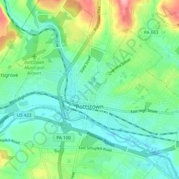
Name: Pottstown topographic map, elevation, terrain.
Average elevation: 226 ft
Minimum elevation: 112 ft
Maximum elevation: 518 ft
Montgomery County trails, hiking, mountain biking, running and outdoor activities
Make a donation
Gear up for your next adventure:
As an Amazon Associate, this site earns from qualifying purchases at no extra cost to you.
Other topographic maps
Click on a map to view its topography, its elevation and its terrain.
Evansburg State Park
United States > Pennsylvania > Montgomery County > Worcester Township > Cedars
Average elevation: 230 ft
Upper Glasgow
United States > Pennsylvania > Montgomery County > West Pottsgrove Township
Average elevation: 282 ft
Dresher
United States > Pennsylvania > Montgomery County > Upper Dublin Township
Average elevation: 269 ft
Fitzwatertown
United States > Pennsylvania > Montgomery County > Upper Dublin Township
Average elevation: 282 ft
Make a donation
Gear up for your next adventure:
As an Amazon Associate, this site earns from qualifying purchases at no extra cost to you.
Woxall
United States > Pennsylvania > Montgomery County > Upper Salford Township
Average elevation: 322 ft
Hamilton Court
United States > Pennsylvania > Montgomery County > Lower Merion Township > Ardmore
Average elevation: 335 ft
Arlingham
United States > Pennsylvania > Montgomery County > Springfield Township
Average elevation: 217 ft
Rydal Park
United States > Pennsylvania > Montgomery County > Abington Township
Average elevation: 285 ft
Make a donation
Gear up for your next adventure:
As an Amazon Associate, this site earns from qualifying purchases at no extra cost to you.
Gwynedd Valley
United States > Pennsylvania > Montgomery County > Lower Gwynedd Township
Average elevation: 305 ft
Mont Clare
United States > Pennsylvania > Montgomery County > Upper Providence Township
Average elevation: 184 ft
Fagleysville
United States > Pennsylvania > Montgomery County > New Hanover Township
Average elevation: 344 ft
Make a donation
Gear up for your next adventure:
As an Amazon Associate, this site earns from qualifying purchases at no extra cost to you.
Morganville
United States > Pennsylvania > Montgomery County > Upper Moreland Township > Willow Grove
Average elevation: 266 ft
Gladwyne
United States > Pennsylvania > Montgomery County > Lower Merion Township
Average elevation: 302 ft
Marble Hall
United States > Pennsylvania > Montgomery County > Whitemarsh Township
Average elevation: 210 ft
Make a donation
Gear up for your next adventure:
As an Amazon Associate, this site earns from qualifying purchases at no extra cost to you.
Franklinville
United States > Pennsylvania > Montgomery County > Whitpain Township
Average elevation: 308 ft
Ashmead Village
United States > Pennsylvania > Montgomery County > Cheltenham Township > Cheltenham
Average elevation: 167 ft
Jeffersonville
United States > Pennsylvania > Montgomery County > West Norriton Township
Average elevation: 184 ft
Cedars
United States > Pennsylvania > Montgomery County > Worcester Township
Average elevation: 230 ft
Make a donation
Gear up for your next adventure:
As an Amazon Associate, this site earns from qualifying purchases at no extra cost to you.
Huntingdon Valley
United States > Pennsylvania > Montgomery County > Lower Moreland Township
Average elevation: 213 ft
Gladwyne
United States > Pennsylvania > Montgomery County > Lower Merion Township
Average elevation: 302 ft
Huntingdon Valley
United States > Pennsylvania > Montgomery County > Lower Moreland Township
Average elevation: 213 ft
Brandywine Village
United States > Pennsylvania > Montgomery County > Upper Merion Township
Average elevation: 164 ft
Make a donation
Gear up for your next adventure:
As an Amazon Associate, this site earns from qualifying purchases at no extra cost to you.
Edge Hill
United States > Pennsylvania > Montgomery County > Cheltenham Township > Glenside
Average elevation: 308 ft
Betzwood
United States > Pennsylvania > Montgomery County > West Norriton Township
Average elevation: 157 ft
Lafayette Hill
United States > Pennsylvania > Montgomery County > Whitemarsh Township
Average elevation: 194 ft
Penn Wynne
United States > Pennsylvania > Montgomery County > Lower Merion Township
Average elevation: 249 ft
Make a donation
Gear up for your next adventure:
As an Amazon Associate, this site earns from qualifying purchases at no extra cost to you.
Hidden Valley
United States > Pennsylvania > Montgomery County > Upper Merion Township
Average elevation: 154 ft
Bryn Mawr
United States > Pennsylvania > Montgomery County > Lower Merion Township
Average elevation: 358 ft
Three Tuns
United States > Pennsylvania > Montgomery County > Upper Dublin Township > Maple Glen
Average elevation: 331 ft
Penllyn
United States > Pennsylvania > Montgomery County > Lower Gwynedd Township
Average elevation: 279 ft
Make a donation
Gear up for your next adventure:
As an Amazon Associate, this site earns from qualifying purchases at no extra cost to you.
Mainland
United States > Pennsylvania > Montgomery County > Lower Salford Township
Average elevation: 259 ft
New Hanover
United States > Pennsylvania > Montgomery County > New Hanover Township
Average elevation: 299 ft
Gwynedd
United States > Pennsylvania > Montgomery County > Lower Gwynedd Township
Average elevation: 364 ft
Willow Grove
United States > Pennsylvania > Montgomery County > Upper Moreland Township
Average elevation: 299 ft
Make a donation
Gear up for your next adventure:
As an Amazon Associate, this site earns from qualifying purchases at no extra cost to you.
Belmont Terrace
United States > Pennsylvania > Montgomery County > Upper Merion Township > King of Prussia
Average elevation: 148 ft
Plymouth Meeting
United States > Pennsylvania > Montgomery County > Whitemarsh Township
Average elevation: 177 ft
Bala Cynwyd
United States > Pennsylvania > Montgomery County > Lower Merion Township
Average elevation: 246 ft
Eagleville
United States > Pennsylvania > Montgomery County > Lower Providence Township
Average elevation: 335 ft
Make a donation
Gear up for your next adventure:
As an Amazon Associate, this site earns from qualifying purchases at no extra cost to you.
Wynmere Downs
United States > Pennsylvania > Montgomery County > Horsham Township
Average elevation: 322 ft
Unami Creek
United States > Pennsylvania > Montgomery County > Marlborough Township
Average elevation: 410 ft
Elkins Park Gardens
United States > Pennsylvania > Montgomery County > Cheltenham Township > Cheltenham
Average elevation: 230 ft
Make a donation
Gear up for your next adventure:
As an Amazon Associate, this site earns from qualifying purchases at no extra cost to you.
Lafayette Hill
United States > Pennsylvania > Montgomery County > Whitemarsh Township
Average elevation: 194 ft
Limerick
United States > Pennsylvania > Montgomery County > Limerick Township
Average elevation: 282 ft
Oreland
United States > Pennsylvania > Montgomery County > Upper Dublin Township
Average elevation: 262 ft
Bala Cynwyd
United States > Pennsylvania > Montgomery County > Lower Merion Township
Average elevation: 249 ft
Make a donation
Gear up for your next adventure:
As an Amazon Associate, this site earns from qualifying purchases at no extra cost to you.
Lafayette Park
United States > Pennsylvania > Montgomery County > King of Prussia > Lafayette Park
Average elevation: 177 ft
Haverford
United States > Pennsylvania > Montgomery County > Lower Merion Township > Ardmore
Average elevation: 338 ft
Penn Valley
United States > Pennsylvania > Montgomery County > Lower Merion Township > Ardmore
Average elevation: 292 ft
Ashbourne
United States > Pennsylvania > Montgomery County > Cheltenham Township
Average elevation: 230 ft
Make a donation
Gear up for your next adventure:
As an Amazon Associate, this site earns from qualifying purchases at no extra cost to you.
Elkins Park Gardens
United States > Pennsylvania > Montgomery County > Cheltenham Township > Cheltenham
Average elevation: 230 ft
Albidale
United States > Pennsylvania > Montgomery County > Lower Moreland Township > Albidale
Average elevation: 253 ft
Mount Joy
United States > Pennsylvania > Montgomery County > Upper Merion Township
Average elevation: 226 ft
Haverford
United States > Pennsylvania > Montgomery County > Lower Merion Township > Ardmore
Average elevation: 338 ft
Make a donation
Gear up for your next adventure:
As an Amazon Associate, this site earns from qualifying purchases at no extra cost to you.
Mainland
United States > Pennsylvania > Montgomery County > Lower Salford Township
Average elevation: 259 ft
Village of Mingo
United States > Pennsylvania > Montgomery County > Upper Providence Township
Average elevation: 230 ft
Bergey
United States > Pennsylvania > Montgomery County > Upper Salford Township
Average elevation: 305 ft
Palm
United States > Pennsylvania > Montgomery County > Upper Hanover Township
Average elevation: 430 ft
Make a donation
Gear up for your next adventure:
As an Amazon Associate, this site earns from qualifying purchases at no extra cost to you.