
Amesbury topographic map
Interactive map
Click on the map to display elevation.
Amesbury
Amesbury is located at 42°51′29″N 70°55′50″W / 42.85806°N 70.93056°W / 42.85806; -70.93056. According to the United States Census Bureau, the city has a total area of 13.7 square miles (35.5 km2), of which 12.3 square miles (31.8 km2) is land and 1.5 square miles (3.8 km2), or 10.65%, is water. Amesbury is drained by the Powwow River. Powwow Hill, elevation 331 feet (101 m), is the highest point in town. Once the site of Indian gatherings, or "powwows", it has views to Maine and Cape Ann. Amesbury is the second northernmost town in Massachusetts, its northernmost point coming just south of the northernmost point of the state, in Salisbury. Amesbury lies along the northern banks of the Merrimack River and is bordered by Salisbury to the east, Newburyport to the southeast, West Newbury to the southwest, Merrimac to the west, and South Hampton, New Hampshire, to the north.
About this map
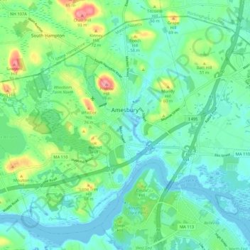
Name: Amesbury topographic map, elevation, terrain.
Location: Amesbury, Essex County, Massachusetts, 01913, United States (42.81971 -71.00490 42.88665 -70.89983)
Average elevation: 82 ft
Minimum elevation: -30 ft
Maximum elevation: 325 ft
Essex County trails, hiking, mountain biking, running and outdoor activities
Other topographic maps
Click on a map to view its topography, its elevation and its terrain.
Haverhill
United States > Massachusetts > Essex County > Haverhill
According to the United States Census Bureau, the city has a total area of 35.6 square miles (92.3 km2), of which 33.0 square miles (85.4 km2) is land and 2.7 square miles (6.9 km2), or 7.47%, is water. The city ranks 60th in the Commonwealth in terms of land area, and is the largest city or town in Essex…
Average elevation: 148 ft
Deer Island
United States > Massachusetts > Essex County > Amesbury > Salisbury Point
Average elevation: 49 ft
Whaleback
United States > Massachusetts > Essex County > Manchester-by-the-Sea
Average elevation: 39 ft
East Point/Henry Cabot Lodge,Jr., Memorial Park
United States > Massachusetts > Essex County > Nahant
Average elevation: 3 ft
Dix Park
United States > Massachusetts > Essex County > Beverly > Beverly Farms
Average elevation: 62 ft
Veasey Memorial Park
United States > Massachusetts > Essex County > Groveland > South Groveland
Average elevation: 112 ft
Stevens Crossing
United States > Massachusetts > Essex County > North Andover
Average elevation: 167 ft
South Salem
United States > Massachusetts > Essex County > Salem > South Salem
Average elevation: 36 ft
Pigeon Cove
United States > Massachusetts > Essex County > Rockport > Pigeon Cove
Average elevation: 66 ft
Magnolia
United States > Massachusetts > Essex County > Gloucester > Magnolia
Average elevation: 33 ft
Amesbury
United States > Massachusetts > Essex County > Amesbury
Amesbury is located at 42°51′29″N 70°55′50″W / 42.85806°N 70.93056°W / 42.85806; -70.93056. According to the United States Census Bureau, the city has a total area of 13.7 square miles (35.5 km2), of which 12.3 square miles (31.8 km2) is land and 1.5 square miles (3.8 km2), or 10.65%, is…
Average elevation: 79 ft