
Make a donation
Gear up for your next adventure:
As an Amazon Associate, this site earns from qualifying purchases at no extra cost to you.
Manteo topographic map
Click on the map to display elevation.
Make a donation
Gear up for your next adventure:
As an Amazon Associate, this site earns from qualifying purchases at no extra cost to you.
About this map
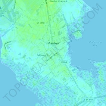
Name: Manteo topographic map, elevation, terrain.
Location: Manteo, Dare County, North Carolina, United States (35.89005 -75.68032 35.91999 -75.63723)
Average elevation: 7 ft
Minimum elevation: -13 ft
Maximum elevation: 30 ft
Dare County trails, hiking, mountain biking, running and outdoor activities
Make a donation
Gear up for your next adventure:
As an Amazon Associate, this site earns from qualifying purchases at no extra cost to you.
Other topographic maps
Click on a map to view its topography, its elevation and its terrain.
Make a donation
Gear up for your next adventure:
As an Amazon Associate, this site earns from qualifying purchases at no extra cost to you.
Make a donation
Gear up for your next adventure:
As an Amazon Associate, this site earns from qualifying purchases at no extra cost to you.
Kill Devil Hills
United States > North Carolina > Dare County > Kill Devil Hills
First Flight Airport covers an area of 40 acres at an elevation of 13 feet (4 metres) above mean sea level. It has one runway; designated 2/20, with an asphalt surface measuring 3,000 by 60 feet (914 by 18 metres). For the 12-month period ending August 19, 2009, the airport had 38,120 aircraft operations, an…
Average elevation: 3 ft