
Chao topographic map
Click on the map to display elevation.
About this map
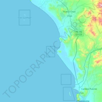
Name: Chao topographic map, elevation, terrain.
Location: Chao, Peru (-9.08028 -79.11583 -8.44028 -78.47583)
Average elevation: 322 ft
Minimum elevation: -3 ft
Maximum elevation: 5,486 ft
Other topographic maps
Click on a map to view its topography, its elevation and its terrain.
Sacred Valley of the Incas
The valley, running generally west to east, is understood to include everything along the Urubamba River between the town and Inca ruins at Písac and Machu Picchu, 100 kilometres (62 mi) distant. The Sacred Valley has elevations above sea level along the river ranging from 3,000 metres (9,800 ft) at Pisac to…
Average elevation: 12,493 ft
Vilcabamba
Vilcabamba District is one of fourteen districts of the La Convención Province in the Cusco Region in Peru. The capital of the province is the Centro Poblado Lucma, which has an elevation of 2,943 metres (9,656 ft). Vitcos was an important city of the Neo-Inca State (1537-1572). Its ruins are now preserved as…
Average elevation: 9,088 ft
City of Cuzco
Cusco is the seventh-most populous city in Peru; in 2017, it had a population of 428,450. It is also the largest city in the Peruvian Andes and the region is the seventh-most populous metropolitan area of Peru. Its elevation is around 3,400 m (11,200 ft). The largest district in the city is the Cusco District,…
Average elevation: 11,329 ft
Machu Picchu
Peru > Cusco > Machupicchu > San Miguel
Animals are also suspected to have immigrated to Machu Picchu as there were several bones found that were not native to the area. Most animal bones found were from llamas and alpacas. These animals naturally live at altitudes of 4,000 metres (13,000 ft) rather than the 2,400 metres (7,900 ft) elevation of…
Average elevation: 7,306 ft
Colca Canyon
Peru > Arequipa > Cabanaconde
In May 1981, the Polish Canoandes rafting expedition, led by Andrzej Pietowski, made the first descent of the river below Cabanaconde and proclaimed the possibility of its being the world's deepest canyon. It was so recognized by the Guinness Book of Records in 1984, and a National Geographic article in…
Average elevation: 10,397 ft
Cajamarca
Cajamarca (Spanish pronunciation: [kaxaˈmaɾka]; Quechua: Kashamarka; Aymara: Qajamarka) is a department and region in Peru. The capital is the city of Cajamarca. It is located in the north part of the country and shares a border with Ecuador. The city has an elevation of 2,700 metres (8,900 ft) above sea…
Average elevation: 4,777 ft
Huascarán National Park
Huascarán National Park protects the Cordillera Blanca, which is the world's highest tropical mountain range. Located in the central Peruvian Andes, the park's 340,000 hectares (840,000 acres) cover an elevational range from around 2,500 meters (8,200 ft) to the several snow-capped peaks above 6,000 meters…
Average elevation: 12,077 ft
Province of Yungay
The Cordillera Blanca and the Cordillera Negra traverse the province. Waskaran, the highest elevation of Peru, lies on the border with the province of Carhuaz. Chakrarahu, Chopicalqui, Tullparahu and Yanarahu (Ruriqucha) belong to the highest peaks of the province. Other mountains are listed below.
Average elevation: 12,493 ft
Sacsayhuamán
Peru > Cusco > Cuzco > Mollococha
Sacsayhuamán (/ˈsæksaɪˌwʌmən/ SACK-sy-wuh-mən; Spanish pronunciation: [saksajwaˈman]) or Saksaywaman (from Quechua Saksay waman pukara, pronounced [ˈsaksaj ˈwaman], lit. 'fortress of the royal falcon or hawk') is a citadel on the northern outskirts of the city of Cusco, Peru, the historic capital…
Average elevation: 11,739 ft
Amazonas
The Amazonian Andes are constituted by the oriental flank of the Andes, covered originally by a dense Amazon vegetation. It spread from the cordillera spurs until reaching surprising altitudes where the forests have not been felled, in certain cases exceeding the 3 500 m.
Average elevation: 3,671 ft
Manu National Park
Manu National Park covers an area of 1,716,295.22 hectares (17,162.95 km2) which comprises mountainous areas (traversed by creeks and valleys) with elevations close to 4000 m above sea level and a portion of the Amazon Basin plains.
Average elevation: 3,314 ft
Surquillo
Since the beginning of the 2000s and the beginning of the 2010s, and to a greater extent today, there has been a considerable real estate boom within Surquillo, in which many residential real estate companies have invested in new residential building projects in several points of the district due to the…
Average elevation: 394 ft
Cordillera Huayhuash
The area preserves high elevation Andean grasslands and patches of forest. Some of the native tree species present in the area are the Andean alder and trees of the genus Polylepis.
Average elevation: 15,833 ft
Chinchaypujio
The district of Chinchaypujio has a 2,000-metre (6,600 ft) altitude spread from south to north; hence, the district is home to multiple climate zones. In the south, the Apurímac River runs at 2,200-metre (7,200 ft) elevation where Banana Isla Maleño and other tropical fruit can be grown, in the north, the…
Average elevation: 11,824 ft
Cajamarca
Cajamarca (Spanish pronunciation: [kaxaˈmaɾka]; Quechua: Kashamarka; Aymara: Qajamarka) is a department and region in Peru. The capital is the city of Cajamarca. It is located in the north part of the country and shares a border with Ecuador. The city has an elevation of 2,700 metres (8,900 ft) above sea…
Average elevation: 4,777 ft
City of Cuzco
Cusco, often spelled Cuzco[a] ([ˈkusko]; Quechua: Qusqu ([ˈqɔsqɔ])), is a city in Southeastern Peru near the Urubamba Valley of the Andes mountain range. It is the capital of the Cusco Region and of the Cusco Province. The city is the seventh most populous in Peru; in 2017, it had a population of 428,450.…
Average elevation: 11,329 ft
Piura
Topography is smooth in the coast and rough in the Sierra. There are many arid plains in the southern region. The Sechura Desert, located south of the Piura River, is Peru's largest desert and one of the world's few examples of a tropical desert; it borders a tropical terrain to the north. The Bayóvar…
Average elevation: 2,215 ft
Ica
Ica has significant wine and pisco industries, annual fiestas, a museum and historic colonial churches. The climate is generally sunny and dry due to its elevation above coastal fog and mist. As of 2020, the Peruvian desert, around the Huacachina Oasis, has gotten significantly popular among tourists for…
Average elevation: 5,328 ft
Province of Oxapampa
Oxapampa is the largest of three provinces that make up the Pasco Region in Peru. The capital of the province is the city of Oxapampa. The province is located on the eastern slopes of the Andes reaching down to the lowlands of the Amazon Basin. The high point of the province is approximately 5,300 metres…
Average elevation: 4,423 ft
Lake Titicaca
Lake Titicaca has a surface elevation of 3,812 m (12,507 ft). The "highest navigable lake" claim is generally considered to refer to commercial craft. Numerous smaller bodies of water around the world are at higher elevations. For many years, the largest vessel afloat on the lake was the 2,200-ton (2,425 U.S.…
Average elevation: 12,697 ft
Villa Rica
The District of Villa Rica is on the eastern slopes of the Andes mountains in an area of abundant rainfall and mild temperatures. It is located in the ecological zone of the Peruvian Yungas, or Ceja de Selva ("eyebrow of the jungle"), the transition zone between the low jungles of the Amazon Basin and the…
Average elevation: 5,604 ft