Charlotte topographic map
Interactive map
Click on the map to display elevation.
About this map
![Charlotte topographic map, elevation, terrain](/pub/maps/relation/g4tf/mmr51/thumbnail.jpg)
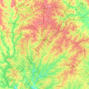
Name: Charlotte topographic map, elevation, terrain.
Location: Charlotte, Mecklenburg County, North Carolina, United States (35.01052 -81.00955 35.40025 -80.63488)
Average elevation: 679 ft
Minimum elevation: 499 ft
Maximum elevation: 889 ft
According to the United States Census Bureau, the city has a total area of 308.6 square miles (799 km2), of which 306.6 square miles (794 km2) is land and 2.0 square miles (5.2 km2) is water. Charlotte is the twenty-sixth-most expansive city in the United States and lies at an elevation of 751 feet (229 m). Charlotte constitutes most of Mecklenburg County in the Carolina Piedmont. Uptown Charlotte sits atop a long rise between two creeks, Sugar Creek and Irwin Creek, and was built on the gunnies of the St. Catherine's and Rudisill gold mines. Charlotte is 25 miles (40 km) southwest of Concord, 26 miles (41 km) northeast of Rock Hill, South Carolina, 83 miles (144 km) southwest of Greensboro, 135 miles (217 km) west of Fayetteville, and 165 miles (265 km) southwest of Raleigh, the state capitol.
Other topographic maps
Click on a map to view its topography, its elevation and its terrain.
![Pineville topographic map, elevation, terrain](/pub/maps/relation/gwtf/mml51/icon.jpg)
Pineville
United States > North Carolina > Mecklenburg County
Pineville, Mecklenburg County, North Carolina, 28134, United States
Average elevation: 577 ft
![Huntersville topographic map, elevation, terrain](/pub/maps/relation/lg51/f711h/icon.jpg)
Huntersville
United States > North Carolina > Mecklenburg County
Huntersville, Mecklenburg County, North Carolina, United States
Average elevation: 741 ft
![Westchester topographic map, elevation, terrain](/pub/maps/node/ct3q/dg2q614/icon.jpg)
Westchester
United States > North Carolina > Mecklenburg County > Charlotte
Westchester, Charlotte, Mecklenburg County, North Carolina, 28130, United States
Average elevation: 761 ft
![Beverly Woods East topographic map, elevation, terrain](/pub/maps/way/df1h/kml2sj57/icon.jpg)
Beverly Woods East
United States > North Carolina > Mecklenburg County > Charlotte
Beverly Woods East, Charlotte, Mecklenburg County, North Carolina, United States
Average elevation: 666 ft
![Matthews topographic map, elevation, terrain](/pub/maps/relation/6d14/99b4s/icon.jpg)
Matthews
United States > North Carolina > Mecklenburg County
Matthews, Mecklenburg County, North Carolina, United States
Average elevation: 696 ft
![Catawba Colony topographic map, elevation, terrain](/pub/maps/node/9hb3/m6gl751/icon.jpg)
Catawba Colony
United States > North Carolina > Mecklenburg County
Catawba Colony, Mecklenburg County, North Carolina, 29012, United States
Average elevation: 633 ft
![Coulwood Park topographic map, elevation, terrain](/pub/maps/way/mc1h/gjvtmcz/icon.jpg)
Coulwood Park
United States > North Carolina > Mecklenburg County > Charlotte > Coulwood Hills
Coulwood Park, Coulwood Hills, Charlotte, Mecklenburg County, North Carolina, 28214, United States
Average elevation: 692 ft
![Oakdale Forest topographic map, elevation, terrain](/pub/maps/node/86dn/9z79g4s/icon.jpg)
Oakdale Forest
United States > North Carolina > Mecklenburg County > Charlotte
Oakdale Forest, Charlotte, Mecklenburg County, North Carolina, 28130, United States
Average elevation: 745 ft
![Yorkmont topographic map, elevation, terrain](/pub/maps/node/j35k/fgf731h/icon.jpg)
Yorkmont
United States > North Carolina > Mecklenburg County > Charlotte
Yorkmont, Charlotte, Mecklenburg County, North Carolina, 28217, United States
Average elevation: 689 ft
![Deerwood topographic map, elevation, terrain](/pub/maps/node/kf4s/dbfnjz4/icon.jpg)
Deerwood
United States > North Carolina > Mecklenburg County > Charlotte
Deerwood, Charlotte, Mecklenburg County, North Carolina, 28214, United States
Average elevation: 722 ft
![Charlotte topographic map, elevation, terrain](/pub/maps/node/lf14/kjpwtb3/icon.jpg)
Charlotte
United States > North Carolina > Mecklenburg County > Charlotte
Charlotte, Mecklenburg County, North Carolina, 28202, United States
Average elevation: 692 ft
![Fox Run topographic map, elevation, terrain](/pub/maps/way/ssgp/p183zvgt/icon.jpg)
Fox Run
United States > North Carolina > Mecklenburg County > Charlotte
Fox Run, Charlotte, Mecklenburg County, North Carolina, United States
Average elevation: 689 ft
![Mint Hill topographic map, elevation, terrain](/pub/maps/relation/kznh/l62tp/icon.jpg)
Mint Hill
United States > North Carolina > Mecklenburg County
Mint Hill, Mecklenburg County, North Carolina, 28227, United States
Average elevation: 715 ft
![Mecklenburg County Sportsplex at Matthews topographic map, elevation, terrain](/pub/maps/way/wpkl/p3b2l14/icon.jpg)
Mecklenburg County Sportsplex at Matthews
United States > North Carolina > Mecklenburg County > Matthews > Club View Acres
Mecklenburg County Sportsplex at Matthews, Club View Acres, Matthews, Mecklenburg County, North Carolina, 28105, United States
Average elevation: 738 ft
![Mecklenberg Wildlife Club Lake topographic map, elevation, terrain](/pub/maps/way/kv4s/sszm118/icon.jpg)
Mecklenberg Wildlife Club Lake
United States > North Carolina > Mecklenburg County > Charlotte
Mecklenberg Wildlife Club Lake, Charlotte, Mecklenburg County, North Carolina, United States
Average elevation: 702 ft
![Hope Farm topographic map, elevation, terrain](/pub/maps/node/hxgt/s9glnmt/icon.jpg)
Hope Farm
United States > North Carolina > Mecklenburg County > Charlotte
Hope Farm, Charlotte, Mecklenburg County, North Carolina, 28214, United States
Average elevation: 656 ft
![Olde Georgetowne topographic map, elevation, terrain](/pub/maps/node/pwgt/sxtmrmt/icon.jpg)
Olde Georgetowne
United States > North Carolina > Mecklenburg County > Charlotte
Olde Georgetowne, Charlotte, Mecklenburg County, North Carolina, 28210, United States
Average elevation: 636 ft
![President James K. Polk State Historic Site topographic map, elevation, terrain](/pub/maps/way/9w14/shcjff3/icon.jpg)
President James K. Polk State Historic Site
United States > North Carolina > Mecklenburg County > Pineville
President James K. Polk State Historic Site, Downtown, Pineville, Mecklenburg County, North Carolina, 28134, United States
Average elevation: 574 ft
![Providence topographic map, elevation, terrain](/pub/maps/node/7wkl/5167l57/icon.jpg)
Providence
United States > North Carolina > Mecklenburg County > Charlotte
Providence, Charlotte, Mecklenburg County, North Carolina, 28270, United States
Average elevation: 669 ft
![Jetton Park topographic map, elevation, terrain](/pub/maps/way/kvtf/cvl9857/icon.jpg)
Jetton Park
United States > North Carolina > Mecklenburg County > Cornelius
Jetton Park, Cornelius, Mecklenburg County, North Carolina, United States
Average elevation: 784 ft
![North Mecklenburg Park topographic map, elevation, terrain](/pub/maps/way/7p14/45nkmnh/icon.jpg)
North Mecklenburg Park
United States > North Carolina > Mecklenburg County > Huntersville
North Mecklenburg Park, Huntersville, Mecklenburg County, North Carolina, 28078, United States
Average elevation: 781 ft
![Raintree topographic map, elevation, terrain](/pub/maps/node/xc9m/kjzgbb3/icon.jpg)
Raintree
United States > North Carolina > Mecklenburg County > Charlotte
Raintree, Charlotte, Mecklenburg County, North Carolina, 28226, United States
Average elevation: 617 ft
![Deschutes Pond topographic map, elevation, terrain](/pub/maps/way/wh3l/kcnr9m57/icon.jpg)
Deschutes Pond
United States > North Carolina > Mecklenburg County > Huntersville
Deschutes Pond, Rosedale, Huntersville, Mecklenburg County, North Carolina, United States
Average elevation: 735 ft
![Carmel Road Park topographic map, elevation, terrain](/pub/maps/way/68mt/w64nfnx/icon.jpg)
Carmel Road Park
United States > North Carolina > Mecklenburg County > Charlotte > Carmel Woods
Carmel Road Park, Carmel Woods, Charlotte, Mecklenburg County, North Carolina, 28266, United States
Average elevation: 650 ft
![Reedy Creek topographic map, elevation, terrain](/pub/maps/way/zntj/4p9mhgp/icon.jpg)
Reedy Creek
United States > North Carolina > Mecklenburg County > Charlotte
Reedy Creek, Charlotte, Mecklenburg County, North Carolina, 28215, United States
Average elevation: 725 ft
![Hope Park topographic map, elevation, terrain](/pub/maps/node/wk18/656gr9m/icon.jpg)
Hope Park
United States > North Carolina > Mecklenburg County > Charlotte > Hope Park
Hope Park, Charlotte, Mecklenburg County, North Carolina, 28215, United States
Average elevation: 764 ft
![Davidson topographic map, elevation, terrain](/pub/maps/relation/5n3l/h8jrr/icon.jpg)
Davidson
United States > North Carolina > Mecklenburg County
Davidson, Mecklenburg County, North Carolina, United States
Average elevation: 764 ft
![Matthews topographic map, elevation, terrain](/pub/maps/node/dltp/n37qz3q/icon.jpg)
Matthews
United States > North Carolina > Mecklenburg County > Matthews
Matthews, Mecklenburg County, North Carolina, 28105-4837, United States
Average elevation: 699 ft
![Clear Creek topographic map, elevation, terrain](/pub/maps/way/d18/k6r34t6/icon.jpg)
Clear Creek
United States > North Carolina > Mecklenburg County > Mint Hill
Clear Creek, Mint Hill, Mecklenburg County, North Carolina, United States
Average elevation: 673 ft
![Sharonbrook topographic map, elevation, terrain](/pub/maps/node/3grr/v32xltj/icon.jpg)
Sharonbrook
United States > North Carolina > Mecklenburg County > Charlotte
Sharonbrook, Charlotte, Mecklenburg County, North Carolina, 28143, United States
Average elevation: 614 ft
![Cornelius topographic map, elevation, terrain](/pub/maps/relation/9c14/9gh4s/icon.jpg)
Cornelius
United States > North Carolina > Mecklenburg County
Cornelius, Mecklenburg County, North Carolina, United States
Average elevation: 761 ft
![Woodlea topographic map, elevation, terrain](/pub/maps/node/fvkl/hdnh5rr/icon.jpg)
Woodlea
United States > North Carolina > Mecklenburg County > Woodlea
Woodlea, Mecklenburg County, North Carolina, 28214, United States
Average elevation: 692 ft
![Country Roads topographic map, elevation, terrain](/pub/maps/node/kgz4/b1gt9t6/icon.jpg)
Country Roads
United States > North Carolina > Mecklenburg County > Charlotte > Country Roads
Country Roads, Charlotte, Mecklenburg County, North Carolina, 28270, United States
Average elevation: 653 ft