
Make a donation
Gear up for your next adventure:
As an Amazon Associate, this site earns from qualifying purchases at no extra cost to you.
Zakarpattia Oblast topographic map
Click on the map to display elevation.
Make a donation
Gear up for your next adventure:
As an Amazon Associate, this site earns from qualifying purchases at no extra cost to you.
Zakarpattia Oblast
The largest rivers that flow through the oblast include the Tysa, Borzhava, and the Tereblia. A high altitude lake is located in Rakhiv Raion, which is the highest in the region. It is called Nesamovyte. The lake is located in the Hoverla preserve on the slopes of Turkul mountain. The lake's area is 3,000 square metres (32,000 sq ft) and it is located 1,750 metres (5,740 ft) above sea level.
Make a donation
Gear up for your next adventure:
As an Amazon Associate, this site earns from qualifying purchases at no extra cost to you.
About this map
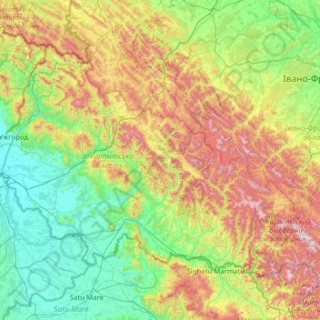
Name: Zakarpattia Oblast topographic map, elevation, terrain.
Location: Zakarpattia Oblast, Ukraine (47.89689 22.13706 49.09732 24.62747)
Average elevation: 1,798 ft
Minimum elevation: 331 ft
Maximum elevation: 6,490 ft
Make a donation
Gear up for your next adventure:
As an Amazon Associate, this site earns from qualifying purchases at no extra cost to you.
Other topographic maps
Click on a map to view its topography, its elevation and its terrain.
Make a donation
Gear up for your next adventure:
As an Amazon Associate, this site earns from qualifying purchases at no extra cost to you.
Make a donation
Gear up for your next adventure:
As an Amazon Associate, this site earns from qualifying purchases at no extra cost to you.
Make a donation
Gear up for your next adventure:
As an Amazon Associate, this site earns from qualifying purchases at no extra cost to you.
Make a donation
Gear up for your next adventure:
As an Amazon Associate, this site earns from qualifying purchases at no extra cost to you.
Make a donation
Gear up for your next adventure:
As an Amazon Associate, this site earns from qualifying purchases at no extra cost to you.
Make a donation
Gear up for your next adventure:
As an Amazon Associate, this site earns from qualifying purchases at no extra cost to you.
Make a donation
Gear up for your next adventure:
As an Amazon Associate, this site earns from qualifying purchases at no extra cost to you.
Hoverla
In the 20th century, the mountain increasingly gained popularity as an extreme sports site. Some routes are classified as 1A in the winter period (from late autumn to May), according to the Soviet grading system. The most popular approach to the summit starts from the tour-basa Zarosliak on the mountain's…
Average elevation: 5,469 ft
Make a donation
Gear up for your next adventure:
As an Amazon Associate, this site earns from qualifying purchases at no extra cost to you.
Make a donation
Gear up for your next adventure:
As an Amazon Associate, this site earns from qualifying purchases at no extra cost to you.
Make a donation
Gear up for your next adventure:
As an Amazon Associate, this site earns from qualifying purchases at no extra cost to you.
Make a donation
Gear up for your next adventure:
As an Amazon Associate, this site earns from qualifying purchases at no extra cost to you.
Make a donation
Gear up for your next adventure:
As an Amazon Associate, this site earns from qualifying purchases at no extra cost to you.
Basivka
The village covers an area of 2,39 km2 at an altitude of 305 metres (1,000 ft) above sea level. The population of village is just about 1042 persons and local government is administered by the Hodovytsko-Basivska village council.
Average elevation: 1,043 ft
Make a donation
Gear up for your next adventure:
As an Amazon Associate, this site earns from qualifying purchases at no extra cost to you.
Make a donation
Gear up for your next adventure:
As an Amazon Associate, this site earns from qualifying purchases at no extra cost to you.
Libknekhtovka
Ukraine > Autonomous Republic of Crimea > Керченський район > Чистопольское сельское поселение
Average elevation: 417 ft
Make a donation
Gear up for your next adventure:
As an Amazon Associate, this site earns from qualifying purchases at no extra cost to you.
Make a donation
Gear up for your next adventure:
As an Amazon Associate, this site earns from qualifying purchases at no extra cost to you.
Make a donation
Gear up for your next adventure:
As an Amazon Associate, this site earns from qualifying purchases at no extra cost to you.
Make a donation
Gear up for your next adventure:
As an Amazon Associate, this site earns from qualifying purchases at no extra cost to you.
Dnipro
The source of the Dnieper is the sedge bogs (Akseninsky Mokh) of the Valdai Hills in central Russia, at an elevation of 220 m (720 ft). For 115 km (71 mi) of its length, it serves as the border between Belarus and Ukraine. Its estuary, or liman, used to be defended by the strong fortress of Ochakiv.
Average elevation: 354 ft
Kolodiivka
It is located in the southernmost portion of the oblast on the Dnister River at an elevation of 273 m (896 ft). The village maintains its own local government as the Kolodiivka Rural Council (Ukrainian: Колодіївська сільська рада), which consists of 21 locally elected deputies.
Average elevation: 827 ft
Make a donation
Gear up for your next adventure:
As an Amazon Associate, this site earns from qualifying purchases at no extra cost to you.
Make a donation
Gear up for your next adventure:
As an Amazon Associate, this site earns from qualifying purchases at no extra cost to you.
Rivnopillia
Ukraine > Republic of Crimea > Simferopol District > Кольчугинское сельское поселение
Average elevation: 210 ft
Make a donation
Gear up for your next adventure:
As an Amazon Associate, this site earns from qualifying purchases at no extra cost to you.
Make a donation
Gear up for your next adventure:
As an Amazon Associate, this site earns from qualifying purchases at no extra cost to you.
Baton
Ukraine > Autonomous Republic of Crimea > Feodosiya City Council > Ordzhonikidze
Average elevation: 26 ft
Make a donation
Gear up for your next adventure:
As an Amazon Associate, this site earns from qualifying purchases at no extra cost to you.
Basivka
The village covers an area of 2,39 km2 at an altitude of 305 metres (1,000 ft) above sea level. The population of village is just about 1042 persons and local government is administered by the Hodovytsko-Basivska village council.
Average elevation: 1,043 ft
Make a donation
Gear up for your next adventure:
As an Amazon Associate, this site earns from qualifying purchases at no extra cost to you.
Dnipro
The source of the Dnieper is the sedge bogs (Akseninsky Mokh) of the Valdai Hills in central Russia, at an elevation of 220 m (720 ft). For 115 km (71 mi) of its length, it serves as the border between Belarus and Ukraine. Its estuary, or liman, used to be defended by the strong fortress of Ochakiv.
Average elevation: 361 ft
Булганакское сопковое поле (Грязевые вулканы)
Ukraine > Autonomous Republic of Crimea > Lenine Raion > Войковское сельское поселение
Average elevation: 246 ft
Make a donation
Gear up for your next adventure:
As an Amazon Associate, this site earns from qualifying purchases at no extra cost to you.